
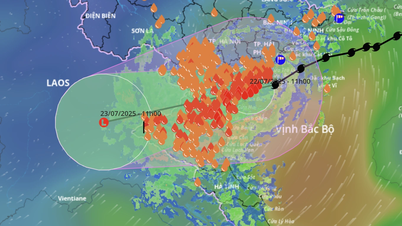
At 11:00 a.m., the storm center was located at approximately 20.1 degrees North latitude and 106.2 degrees East longitude, with the strongest wind near the storm center reaching level 8 (down 1 level compared to before landfall), gusting to level 10. The storm continued to move in a West-Southwest direction at a speed of 10-15km/hour towards Thanh Hoa province.

Many coastal and island areas such as Bach Long Vi, Co To, Cua Ong, Tien Yen (Quang Ninh) and Cat Ba ( Hai Phong )... had strong winds of level 8-10, gusting up to level 14, in which Quang Ninh and Hai Phong areas were most clearly affected.
In the plains and coastal areas of the North, Thanh Hoa and Nghe An, there was moderate to very heavy rain, commonly 70-150mm, in some places exceeding 200mm. Storm surge was recorded at Hon Dau (Hai Phong) at 0.6m high, at Ba Lat (Hung Yen) at 0.8m high.
The National Center for Hydro-Meteorological Forecasting warned that on the afternoon of July 22, the Gulf of Tonkin (including the islands of Bach Long Vi, Co To, Van Don, Cat Hai, Hon Dau, Hon Ngu) will continue to have strong winds of level 6-7, near the storm center of level 8, gusting to level 10; rough seas with waves 2-4m high. The water level along the coast of Hung Yen - Quang Ninh continues to rise.
The Meteorological Agency warns: The weather at sea and in coastal areas is extremely dangerous, unsafe for all activities at sea and in coastal areas, including cruise ships, passenger ships, transport ships, cages, aquaculture areas, dykes, coastal routes. There is a high risk of accidents due to strong winds, storms, big waves and rising water.

On land, coastal areas from Quang Ninh to Nghe An will have strong winds of level 6-7, near the storm center level 8, gusting to level 10; inland areas such as Hai Phong, Hung Yen, Bac Ninh, Hanoi, Ninh Binh, Thanh Hoa will have gusts of level 6-8. Level 8 winds can cause tree branches to fall, roofs to blow off, threatening the safety of homes and people's lives.
Source: https://www.sggp.org.vn/tam-bao-dang-o-hung-yen-ninh-binh-di-chuyen-ve-thanh-hoa-post804860.html


Comment (0)