
Illustration photo.
The National Center for Hydro-Meteorological Forecasting said that on the night of June 7 and June 8, many dangerous weather patterns will appear on land and at sea.
Thanh Hoa and Dak Nong heavy rain
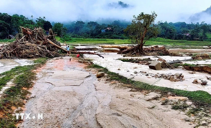
According to the National Center for Hydro-Meteorological Forecasting, from 6:40 p.m. to 11:40 p.m. on June 7, Thanh Hoa and Dak Nong provinces will continue to have rain with the following common accumulated rainfall:
Thanh Hoa from 20-40mm, some places over 70mm; Dak Nong from 10-30mm, some places over 50mm. Risk of flash floods on small rivers and streams, landslides on steep slopes in the above provinces, especially in the districts: Ba Thuoc, Muong Lat, Ngoc Lac, Nhu Xuan, Quan Hoa, Quan Son, Tho Xuan, Thuong Xuan, Trieu Son, Yen Dinh (Thanh Hoa province); Dak Mil, Krong No, Dak Song (Dak Nong province).
Warning level of natural disaster risk due to flash floods, landslides, land subsidence due to heavy rain or level 1 flow.
Heavy rains are likely to cause flooding in low-lying areas, urban and industrial areas; flash floods on small rivers and streams, landslides on steep slopes (real-time warning information on areas at risk of flash floods and landslides is provided online on the website of the Department of Hydrometeorology at: https://luquetsatlo.nchmf.gov.vn and in separate bulletins warning of flash floods and landslides).
Flash floods and landslides can have very negative impacts on the environment, threaten people's lives; cause local traffic congestion, affect the movement of vehicles; destroy civil and economic works, causing damage to production and socio-economic activities.
The hydrometeorological agency reminds people to regularly monitor forecast and warning information on the website of the National Center for Hydro-Meteorological Forecasting at nchmf.gov.vn, and provincial, municipal and regional hydrometeorological stations.
At the same time, regularly update the latest hydrometeorological forecast information on the official mass media of the Central and local levels to proactively respond, and at the same time recommend that the authorities in the affected localities pay attention to reviewing the flow bottlenecks and vulnerable locations in the area to take preventive measures.
According to the guidance of the Department of Dyke Management and Natural Disaster Prevention and Control (Ministry of Agriculture and Environment), in the face of the above situation, affected areas should closely monitor developments of heavy rain, floods, flash floods, landslides, and promptly and fully inform authorities at all levels and people to proactively prevent, respond, and minimize damage.
Localities deploy shock forces to inspect and review residential areas along rivers, streams, and low-lying areas to proactively organize the relocation and evacuation of people in areas at high risk of deep flooding, flash floods, and landslides; organize forces ready to control and direct traffic, and place warning signs, especially through culverts, spillways, and areas with deep flooding and fast-flowing water; proactively arrange forces, materials, and means to overcome incidents, ensuring smooth traffic on main traffic routes when heavy rain occurs...
From 3:00 p.m. to 5:00 p.m. on June 7, there was rain in Thanh Hoa and Dak Nong provinces, with moderate to heavy rain in some places such as: Na Meo 62.8mm (Thanh Hoa); Long Son 79mm (Dak Nong); ...
Soil moisture models show that some areas in the above provinces are close to saturation (over 80%) or have reached saturation.
Many coastal areas have thunderstorms and high waves.
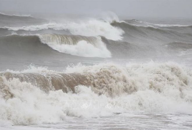
According to information from the National Center for Hydro-Meteorological Forecasting, currently the Central and Southern East Sea (including the Truong Sa sea area), the sea area from Binh Thuan to Ca Mau, Ca Mau to Kien Giang has scattered showers and thunderstorms.
It is forecasted that on the night of June 7 and June 8, the Central and Southern East Sea (including the Truong Sa sea area), the sea area from Binh Thuan to Ca Mau, Ca Mau to Kien Giang and the Gulf of Thailand will have scattered showers and thunderstorms. During thunderstorms, there is a possibility of tornadoes, strong gusts of wind level 6-7, and waves over 2m high.
In addition, on June 8, the sea area from Binh Thuan to Ca Mau, the South East Sea area (including the sea area of Truong Sa) has strong southwest winds of level 5, sometimes level 6, gusting to level 7-8, rough seas, waves 1.5-2.5m high.
All vessels operating in the above areas are at risk of being affected by tornadoes, strong winds and high seas.
According to the guidance of the Ministry of Agriculture and Environment, affected coastal provinces and cities must closely monitor warning bulletins, forecasts and developments of strong winds at sea; notify captains and owners of vehicles and vessels operating at sea to proactively prevent and have appropriate production plans, ensuring safety of people and property; maintain communication to promptly handle possible bad situations.
According to VNA
Source: https://baothanhhoa.vn/nguy-co-lu-quet-sat-lo-o-thanh-hoa-dak-nong-va-loc-xoay-tren-nhieu-vung-bien-251348.htm


![[OCOP REVIEW] Tu Duyen Syrup - The essence of herbs from the mountains and forests of Nhu Thanh](https://vphoto.vietnam.vn/thumb/402x226/vietnam/resource/IMAGE/2025/6/5/58ca32fce4ec44039e444fbfae7e75ec)


Comment (0)