
According to experts, in March, cold air is more active than the average of many years, but because the center is shifted to the East, it causes many days of light rain, drizzle, and fog. From now until almost the end of February, the North will have cold rain.
The National Center for Hydro-Meteorological Forecasting has just released a monthly climate forecast for the whole country. Accordingly, experts say that in the next month (February 21 - March 20), cold air tends to be more active than the average of many years, but because the continental cold high pressure center tends to shift to the East, it can cause many days of light rain, drizzle and fog, especially in the northeastern and north central provinces.
At the same time, during this period, the equatorial low pressure band tends to be active, lifting its axis to the North and is likely to impact the southern provinces and cities in the last days of February 2025.
Therefore, the Central and Southern regions are likely to experience some scattered showers and thunderstorms. In particular, the total rainfall in the Northeast and Central regions is generally 10-30mm higher, in some places over 30mm; the remaining regions are 5-15mm higher than the average of many years in the same period.
The meteorological agency also forecasts that the average temperature across the country will be approximately the same as the average of many years, with the Northeast and North Central regions being 0.5-1 degrees lower than the average of many years during the same period.
In the immediate future, according to the forecast of the Southern Hydrometeorological Station, in the next 1-2 days, the continental cold high pressure will be strengthened again, then stabilize and gradually weaken. Above, the subtropical high pressure with an axis through the Central - South Central region will continue to move westward... Disturbances in the high-altitude East wind zone will be active, affecting the weather in the Southern region until the end of February 24.
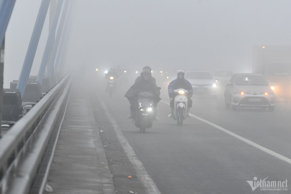
These patterns have a strong impact on the weather in the regions. Notably, according to the National Center for Hydro-Meteorological Forecasting, early this morning (February 23), cold air has affected some places in the northern mountainous region. Today, this cold air will affect other places in the Northeast, Northwest and North Central regions, then the Central Central region.
This cold air mass will cause severe cold in the North from tonight, with some mountainous areas experiencing severe cold; cold in the North Central region, with some areas experiencing severe cold in the North; and combined with strong currents in the upper westerly wind zone on February 23-24, the North and North Central regions will experience rain, light rain.
In addition, during the day and tonight, in the area from Quang Tri to Hue, there will be rain, locally moderate rain, heavy rain with rainfall of 15-30mm, some places over 70mm; the area from Da Nang to Khanh Hoa will have moderate rain, locally heavy rain to very heavy rain and thunderstorms with rainfall of 20-40mm, some places over 100mm.
The Southern Central Highlands and the South also have scattered showers and thunderstorms, locally with moderate to heavy rain (rain concentrated in the afternoon and evening) with rainfall of 10-30mm, some places over 60mm.
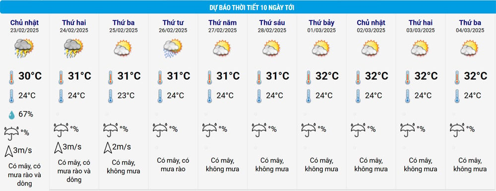
Forecast of the meteorological situation nationwide from February 23-28:
Northern Region
From 23-24/2: scattered rain and light rain; on the night of 24/2, the Northwest region will have scattered showers and thunderstorms. Cold weather, from the night of 23-24/2, very cold, some mountainous areas will be severely cold.
From 25-26/2: scattered showers and thunderstorms. Cold weather, severe cold in some places. Thunderstorms may cause tornadoes, lightning, hail and strong gusts of wind.
From 27-28/2: rain in some places, early morning fog and light fog scattered. Cold morning and night.
Central Region
North Central: from February 23-24, scattered rain; from February 25-26, scattered showers and thunderstorms; later, rain in some places, early morning, scattered fog and light fog. From February 22-25, cold weather, severe cold in some places in the North; cold at night.
Central and South Central regions: on February 22, there will be scattered showers, with some places experiencing moderate to heavy rain; from February 23-25, there will be moderate rain, some places experiencing heavy to very heavy rain and thunderstorms; then there will be rain in some places. During thunderstorms, there is a possibility of tornadoes, lightning, hail and strong gusts of wind.
Central Highlands and South
From 23-28/2: scattered showers and thunderstorms, sunny during the day; from the evening of 23/2, the Southern Central Highlands and the Southern region will have scattered showers and thunderstorms, with some places experiencing moderate to heavy rain. During thunderstorms, there is a possibility of tornadoes, lightning and strong gusts of wind.
Hanoi area
From 23-24/2: scattered rain and light rain. Cold weather, from the night of 23-24/2 it will be very cold.
From 25-26/2: scattered showers and thunderstorms. Cold weather, severe cold in some places. Thunderstorms may cause tornadoes, lightning and strong gusts of wind.
From 27-28/2: rain in some places, early morning fog and light fog scattered. Cold morning and night.
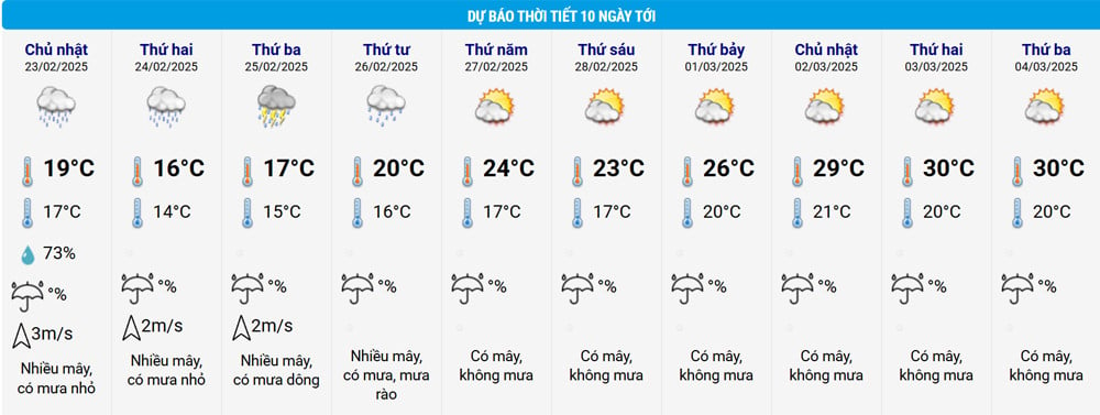
According to the temperature table above, Hanoi's weather tends to stop raining and become sunny from February 27-28, the temperature will increase; drizzle and humidity will also temporarily end.

Strong cold air is about to hit, Central and Southern regions will have heavy rain locally

Strong cold air returns, the North is cold and has continuous rain
Source: https://vietnamnet.vn/khong-khi-lanh-van-hoat-dong-manh-trong-thang-3-nhieu-ngay-mua-phun-nom-am-2374019.html


![[Maritime News] More than 80% of global container shipping capacity is in the hands of MSC and major shipping alliances](https://vphoto.vietnam.vn/thumb/402x226/vietnam/resource/IMAGE/2025/7/16/6b4d586c984b4cbf8c5680352b9eaeb0)


Comment (0)