

Strong winds and thunderstorms are forecast at sea. Photo: VNA

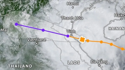
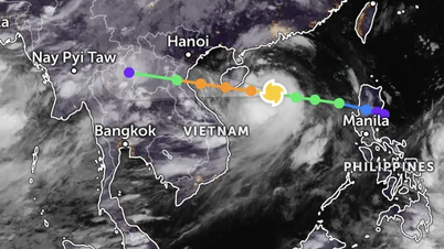
Commenting on the development of natural disasters in the coming days (from August 14-24), on the evening of August 13, Associate Professor, Doctor, Director of the National Center for Hydro-Meteorological Forecasting Mai Van Khiem said that through monitoring and analyzing the current status of the weather system and forecast products, it is possible that from now until the end of August 2025, there will be 1-2 storms and tropical depressions in the East Sea.
On land in the Northern region, Central Highlands and Southern region, thunderstorms and localized heavy rain still frequently occur in the late afternoon and at night.
Specifically, around August 14-15, a tropical convergence zone will form in the central East Sea. This tropical convergence zone is likely to form a low pressure area (which may then develop into a tropical depression) with a probability of about 60-70%.
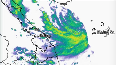
The sea area from Khanh Hoa to Ca Mau , the central and southern East Sea (including the west of Truong Sa special zone) has strong southwest winds of level 6, gusting to level 7-8, waves 2-3m high, rough seas. From August 16, the area of thunderstorms and strong winds is likely to expand to the Gulf of Tonkin.
The sea area from Khanh Hoa to Ca Mau, Ca Mau to An Giang , the Gulf of Thailand, the southern sea area between the East Sea and the South East Sea area (including Truong Sa special zone) has heavy rain and thunderstorms. During thunderstorms, be careful of wave heights that can sometimes increase to over 3m.
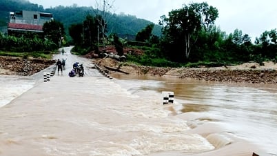
Along with that, due to the influence of the tropical convergence zone, connected with the low pressure area forecast to form in the East Sea, from around August 15 to August 19, in the North (mainly concentrated in the Northeast region) and provinces and cities from Thanh Hoa to Hue, the Central Highlands and the South, there is a possibility of moderate to heavy rain over a wide area with a high risk of tornadoes, lightning, flash floods, landslides and localized flooding.
Director Mai Van Khiem recommends that, in order to proactively respond to the above weather conditions, the government and affected people must absolutely comply with the direction and guidance of the local and national Civil Defense Agency.
The hydrometeorological agency reminds people to regularly monitor forecast and warning information on the website of the National Center for Hydro-Meteorological Forecasting at nchmf.gov.vn, and provincial, municipal and regional hydrometeorological stations.
At the same time, regularly update the latest hydrometeorological forecast information on the official mass media of the Central and local levels to proactively respond.../.
According to Vietnamplus
Source: https://www.vietnamplus.vn/kha-nang-hinh-thanh-vung-ap-thap-va-phat-trien-thanh-ap-thap-nhiet-doi-post1055533.vnp
Source: https://baolongan.vn/kha-nang-hinh-thanh-vung-ap-thap-va-phat-trien-thanh-ap-thap-nhiet-doi-a200617.html


![[Photo] General Secretary To Lam attends the 80th anniversary of Vietnam's diplomacy](https://vphoto.vietnam.vn/thumb/1200x675/vietnam/resource/IMAGE/2025/8/25/3dc715efdbf74937b6fe8072bac5cb30)


Comment (0)