

The Department of Hydrometeorology reported that on the morning of August 25, storm No. 5 remained strong as it approached the coastal area from Thanh Hoa to Ha Tinh with winds of level 14 and gusts of level 17.
On Hainan Island (China), there was over 400mm of rain in 24 hours and storm winds of level 14 with gusts of level 17, forcing about 20,000 people to evacuate urgently.

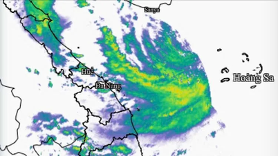
In Vietnam, many coastal meteorological stations from Quang Ninh to Quang Tri have measured strong winds of level 6-7, gusting to level 9-10. Particularly, Ha Tinh and Quang Tri provinces have experienced heavy rain, with some places experiencing over 150mm.
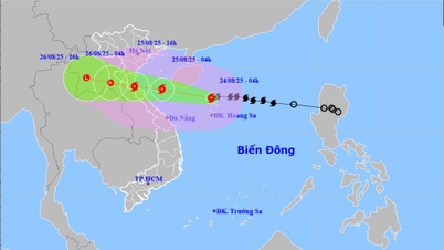
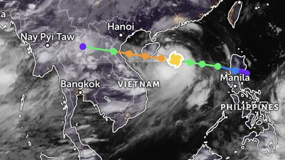
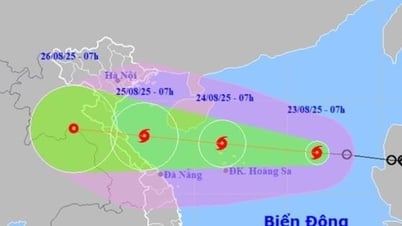
Updated at 10:00 a.m. on August 25, the center of storm No. 5 was at about 18.4 degrees North latitude - 106.8 degrees East longitude, about 120 km East Southeast of Nghe An , about 100 km East of Ha Tinh and about 130 km East Northeast of Quang Tri. The strongest wind near the center of the storm reached level 13-14 (134-166 km/h), gusting to level 16. It is forecasted that in the next 3 hours, the storm will continue to move in a West Northwest direction at a speed of about 15 km/h.

According to the National Center for Hydro-Meteorological Forecasting, while moving into the Ha Tinh - Thanh Hoa sea area, the storm will maintain its intensity at level 14 with gusts of level 15-16 and will only slightly decrease to level 13-14 when approaching the shore. The strongest winds on land are forecast to occur in the South Thanh Hoa - North Ha Tinh area with winds of level 12-14, gusts of level 15-16, with a radius of strong winds above level 12 of about 50km.
According to the meteorological agency, from now until the afternoon when the storm moves into the Ha Tinh - Thanh Hoa sea area, the storm will maintain its intensity at level 14, gusting to level 15-16. When approaching the coast of Ha Tinh - Nghe An, the intensity may decrease to late level 13, early level 14.
The northern Thanh Hoa region and deep inland will have winds of level 8-9, gusting to 10-11, gradually decreasing to level 6-7 as it approaches the Lao border. "The strongest wind time is from 12:00 to about 18:00," said a representative of the National Center for Hydro-Meteorological Forecasting.

According to the representative of the Department of Meteorology and Hydrology, the strong and prolonged intensity of storm No. 5 is due to many factors. The sea surface temperature in the Central region is as high as 30 degrees Celsius, combined with the southwest monsoon and the east wind from the subtropical high pressure, providing energy to maintain the storm's strength. The small wind shear of only 2.5m/s along with the storm circulation being less affected by Hainan Island helps the storm structure to be stable.
The National Center for Hydro-Meteorological Forecasting also added that forecast models from Vietnam, Japan and Hong Kong (China) all agreed that the storm would maintain a level 13-14 intensity, with gusts reaching level 14 in some places when it makes landfall in Vietnam.
Source: https://www.sggp.org.vn/ngay-25-8-bao-so-5-manh-nhat-tu-12-gio-den-khoang-18-gio-cap-13-14-post810046.html


![[Photo] General Secretary To Lam attends the 80th anniversary of Vietnam's diplomacy](https://vphoto.vietnam.vn/thumb/1200x675/vietnam/resource/IMAGE/2025/8/25/3dc715efdbf74937b6fe8072bac5cb30)


Comment (0)