

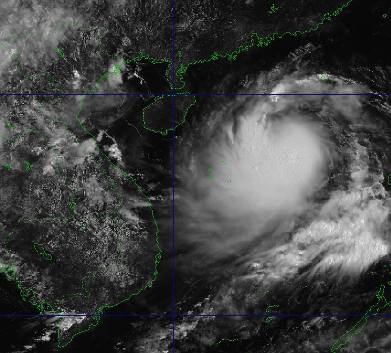
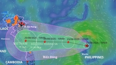
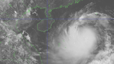
According to the National Center for Hydro-Meteorological Forecasting on the morning of August 23, the tropical depression in the eastern sea of the North East Sea has strengthened into a storm - storm number 5 (international name is Kajiki).
At 10am this morning, the storm center was located at approximately 17.4 degrees North latitude; 115.8 degrees East longitude, approximately 380km East Northeast of Hoang Sa special zone. Strongest wind: Level 8-9 (62-88km/h), gusting to level 11.
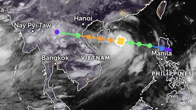
Forecast: In the next 3 hours, the storm will move in the West Northwest direction, at a speed of about 25km/h.
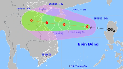
Storm No. 5 increases 4 levels today and tomorrow
Forecast for today and tonight, the storm will maintain its speed, direction of movement and continue to strengthen.
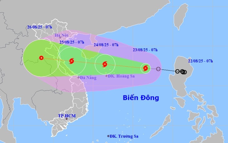
At 7am tomorrow morning, the eye of storm number 5 will be in the sea northwest of Hoang Sa special zone, the storm intensity is currently level 10-11 (89-117km/h), gusting 14.
During tomorrow day and night, the storm will continue to move in the West Northwest direction at a speed of about 20km/h and continue to strengthen.
At 7:00 a.m. on July 25, the storm center was over the sea from Thanh Hoa to Hue, the storm intensity was now level 11-12 (118-133 km/h), gusting to 15.
From the morning to the afternoon of July 25, storm No. 5 will make landfall in the central provinces, with the focus likely being the three provinces of Nghe An, Ha Tinh and Quang Tri.
With fast moving speed, maximum intensity can reach level 11-12, gust level 15, so immediately after strengthening into a storm, the meteorological agency issued an urgent storm bulletin.
From this afternoon, the wind in the Thanh Hoa - Hue sea area will gradually get stronger.
Due to the influence of the storm, in the northern East Sea area (including Hoang Sa special zone), there are strong winds of level 8-9, the area near the storm's center has winds of level 10-11, gusts of level 14, waves 4-6m high, and rough seas.
From the afternoon of August 23, the sea area from Thanh Hoa to Hue (including Con Co and Hon Ngu special zones) will have winds gradually increasing to level 6-8, then increasing to level 9-10, the area near the storm's center will have winds of level 11-12, gusting to level 15, waves 4-6m high, the area near the center will have winds of 6-8m.
From the night of August 23, the northern sea area of Bac Bo Gulf (including Bach Long Vi special zone) will have winds gradually increasing to level 6-7, gusting to level 9, with waves 2-3m high.
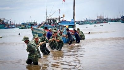
Ships and boats operating in the above-mentioned dangerous areas are likely to be affected by storms, whirlwinds, strong winds and large waves.
The coastal areas of Thanh Hoa - Quang Tri have storm surges of 0.5-1m high. Water levels in Sam Son (Thanh Hoa) are 3.2-3.6m high, in Hon Ngu ( Nghe An ) are 3.3-3.7m high, in Vung Ang (Ha Tinh) are 3.1-3.4m high and in Cua Gianh (Quang Tri) are 1.7-2m high. There is a high risk of flooding in coastal areas and river mouths at noon and afternoon on August 25.
Thanh Hoa - Quang Tri very heavy rain, some places over 600mm
From the night of August 24, on land from Thanh Hoa to Quang Tri, winds will gradually increase to level 7-9, near the storm center level 10-12, gusting to level 14.
The coastal areas of Thanh Hoa - Quang Tri have storm surges of 0.5-1m high. Water levels in Sam Son (Thanh Hoa) are 3.2-3.6m high, in Hon Ngu (Nghe An) are 3.3-3.7m high, in Vung Ang (Ha Tinh) are 3.1-3.4m high and in Cua Gianh (Quang Tri) are 1.7-2m high. There is a high risk of flooding in coastal areas and river mouths at noon and afternoon on August 25.
From tomorrow night (August 24) to the end of August 26, in the Northern Delta region and Thanh Hoa to Hue, there is a possibility of widespread heavy rain with common rainfall of 100-150mm, locally over 250mm in some places.
In particular, the Thanh Hoa to Quang Tri area will have heavy to very heavy rain with common rainfall of 150-300mm, locally over 600mm. Warning of the risk of heavy rain over 200mm in 3 hours.
From August 25 to 26: Hanoi and Da Nang will have moderate to heavy rain and thunderstorms; Ho Chi Minh City will have rain, showers and thunderstorms in the late afternoon and evening; During thunderstorms, be on guard against the risk of tornadoes and strong gusts of wind.
Source: https://baonghean.vn/bao-so-5-du-bao-di-nhanh-tang-lien-4-cap-trong-hom-nay-va-ngay-mai-10305010.html
![[Photo] Prime Minister Pham Minh Chinh chairs the meeting of the Government Party Committee Standing Committee](https://vphoto.vietnam.vn/thumb/1200x675/vietnam/resource/IMAGE/2025/8/23/8e94aa3d26424d1ab1528c3e4bbacc45)


![[Photo] General Secretary To Lam attends the 80th Anniversary of the Cultural Sector's Traditional Day](https://vphoto.vietnam.vn/thumb/1200x675/vietnam/resource/IMAGE/2025/8/23/7a88e6b58502490aa153adf8f0eec2b2)


Comment (0)