

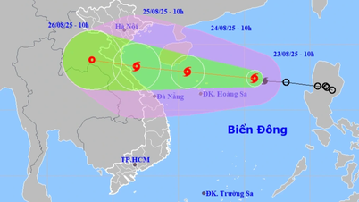
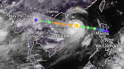
On the evening of August 23, speaking to the press, Mr. Mai Van Khiem, Director of the National Center for Hydro-Meteorological Forecasting, assessed that storm No. 5 is forecast to be a very strong storm, moving quickly and having a very wide range of influence. The storm has increased by two levels compared to the morning of August 23 and is forecast to continue to get stronger in the next 24 to 36 hours.

Mr. Mai Van Khiem said that domestic and international forecast models show that the storm's wind speed can reach level 11-12, gusting to level 15-16. In particular, some models predict that this storm will be even stronger. "We predict that this storm will have wind speed no less than that of Typhoon Yagi that occurred in September 2024 in terms of strong winds," Mr. Mai Van Khiem warned.
The Director of the National Center for Hydro-Meteorological Forecasting said that this storm is even stronger than the Doksuri storm in September 2017 (which had a similar movement and made landfall in the North Central region). In response to this development, on the afternoon of August 23, the Meteorological Agency agreed to upgrade the storm's danger level to level 4 for the area from Thanh Hoa to Hue.
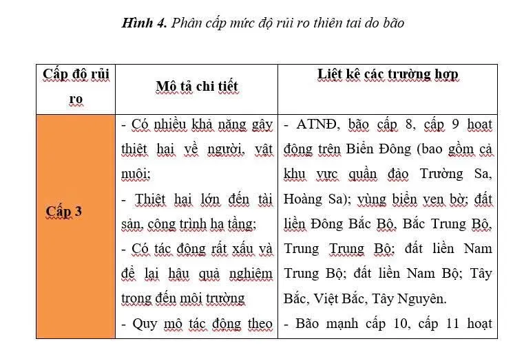

“This is a very dangerous storm level, which can cause great damage to people and property, especially in the area from Thanh Hoa to Hue ,” Mr. Mai Van Khiem informed.


At 9 p.m., the storm's center was at approximately 17.7 degrees North latitude - 113.5 degrees East longitude, approximately 190 km northeast of Hoang Sa, with winds increasing to level 10-11 and gusts of level 12-13. "In the next 3 hours from 9 p.m. on August 23, the storm will move westward at a speed of 20-25 km/h," the National Center for Hydro-Meteorological Forecasting informed.
Information about storm No. 10 - Doksuri (2017)
The National Center for Hydro-Meteorological Forecasting believes that the current storm No. 5 is similar to storm No. 10-2017. The development of storm No. 10 is as follows:
On the morning of September 11, 2017, a low pressure area appeared in the sea east of the central Philippines, then strengthened into a tropical depression. By the afternoon of September 12, this low pressure area crossed the southern area of Luzon Island (Philippines), entered the East Sea and strengthened into storm No. 10, internationally named Doksuri. After forming, the storm moved rapidly in the West-Northwest direction with an average speed of 20-25km/hour.
From the afternoon of September 14, when passing the Hoang Sa archipelago, the storm strengthened to level 12. When entering the southern area of the Gulf of Tonkin, the storm continued to strengthen, reaching level 13, gusting to level 15. By noon of September 15, the storm made landfall in the Ha Tinh - Quang Binh area (now Quang Tri province), then moved to Central Laos.
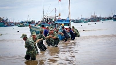
Storm No. 10 formed right in the East Sea, moving quickly and tending to strengthen as it nears shore. The radius of strong winds from level 6 and above exceeds 250km. The storm reaches its strongest intensity at sea with winds of level 13, gusting to level 15; when making landfall, winds reach level 11-12, gusting to level 14. At Ba Don station (formerly in Quang Binh province), the lowest recorded air pressure was 966.6mb at 11:15 a.m. on September 15.
Due to the storm's influence, from September 14 to the morning of September 16, the provinces from Thanh Hoa to Quang Ngai had heavy to very heavy rain with rainfall of 100-200mm; in the Ha Tinh - Quang Tri area alone, it rained 200-300mm, many places exceeded this level such as Tuyen Hoa (formerly Quang Binh) 383mm, Dong Hoi (formerly Quang Binh) 347mm, Cua Viet (Quang Tri) 361mm, Ha Tinh 336mm. The southern region of the Northern Delta, Hoa Binh (now Phu Tho province), Son La also had rain of 50-150mm.
Typhoon Doksuri caused severe damage in the central region, killing at least 6 to 8 people, blowing off the roofs of nearly 200,000 houses and severely damaging many infrastructures. The economic damage was initially estimated at over 11,000 billion VND and was later determined to be up to about 18,400 billion VND.
Source: https://www.sggp.org.vn/bao-so-5-manh-tuong-duong-bao-yagi-gio-giat-cap-15-16-post809860.html
![[Photo] Prime Minister Pham Minh Chinh chairs the meeting of the Government Party Committee Standing Committee](https://vphoto.vietnam.vn/thumb/1200x675/vietnam/resource/IMAGE/2025/8/23/8e94aa3d26424d1ab1528c3e4bbacc45)


![[Photo] General Secretary To Lam attends the 80th Anniversary of the Cultural Sector's Traditional Day](https://vphoto.vietnam.vn/thumb/1200x675/vietnam/resource/IMAGE/2025/8/23/7a88e6b58502490aa153adf8f0eec2b2)


Comment (0)