
According to the Provincial Hydrometeorological Station, the current situation in the past 3 hours: Through monitoring satellite cloud images and Nha Be weather radar images, it shows that convective clouds causing rain are existing in the areas of Can Tho and Vinh Long provinces (Binh Minh, Cai Von, Ngai Tu, Chau Thanh, Don Chau, Vinh Kim...).
 |
In the next 30 - 60 minutes, thunderstorms will continue to develop and cause rain in the above areas, then spread to neighboring communes and wards such as: Cho Lach, Phu Phung, Dong Khoi, Thanh Thoi, Tan Thanh Binh, Thanh Phong...
In the next 1-3 hours, thunderstorms are likely to continue to develop and cause rain in neighboring communes and wards such as: Ben Tre , Son Dong, Bao Thanh, Giong Trom, Luong Phu, Luong Hoa, Binh Dai... some places will have moderate rain and thunderstorms. Estimated rainfall is from 5-7mm.
During thunderstorms, beware of tornadoes, lightning, and strong gusts of wind. Warning level of natural disaster risk due to tornadoes, lightning, and strong gusts of wind: level 1.
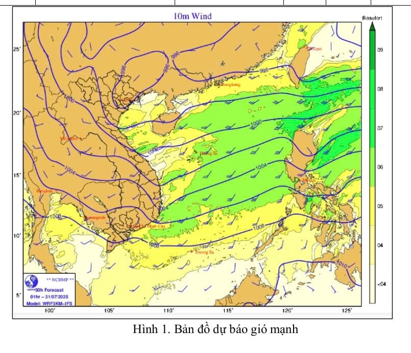
* Also according to the provincial Hydrometeorological Station, currently, at station DK1, there is a southwest wind level 4 (7m/s). It is forecasted that in the next 24 hours (day and night of July 30), the Vinh Long sea area will have a southwest wind level 5 - 6. The sea is rough, wave height from 2 - 3.5m.
Warning: From July 31, the Vinh Long sea area will gradually decrease in intensity, southwest wind level 4, normal sea. Natural disaster risk level due to strong winds at sea: level 2.
Impact Forecast: All vessels operating in the above areas are at high risk of being affected by cyclones, strong winds and large waves.
News and photos: THAO LY
Source: https://baovinhlong.com.vn/thoi-su/202507/du-bao-mua-dong-rai-rac-de-phong-loc-set-va-gio-giat-manh-4671f4b/


![[Maritime News] Container shipping faces overcapacity that will last until 2028](https://vphoto.vietnam.vn/thumb/402x226/vietnam/resource/IMAGE/2025/7/30/6d35cbc6b0f643fd97f8aa2e9bc87aea)


Comment (0)