

Accordingly, the specialized planning of urban transport in Da Nang city to 2030, with a vision to 2045, has a research scope of the entire administrative boundary of Da Nang city (old) with a total area of about 129,046 hectares, of which the mainland area is about 98,546 hectares, the area of Hoang Sa island district (now Hoang Sa special zone) is 30,500 hectares.
In June 2025, Vice Chairman of the City People's Committee Le Quang Nam signed Decision No. 1766 approving the Urban Transport Planning Project of Da Nang City to 2030, with a vision to 2045. The indirect research scope includes areas adjacent to Da Nang City including: the former Quang Nam province, Thua Thien Hue province (now Hue city), provinces in the North Central region and the Central Coast.
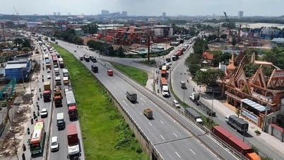
The subjects of planning research include road traffic infrastructure (foreign and domestic), railways, waterways, sea routes, airways, static traffic and public transport systems within the planning scope.
Orientation for development of urban area connections to strengthen connections with subdivisions in the hillside area: Planning to connect the area through the West Belt 1 (Ring 1) routes from the High-tech Industrial Park to Ngu Hanh Son district to create a continuous traffic axis connecting the East and West of the city; connecting the West Belt route to the Hai Van tunnel south bypass, extending the West Belt 2 (Ring 2) route...
In addition, there is a plan to connect the existing main urban routes to ensure internal circulation, traffic safety and reduce the load on the main routes. The underground route runs through the airport area to connect the eastern area with the western development area, along with the development of the public transport system.
Planning urban railway lines or equivalent modes to act as main public transport routes, connecting urban subdivisions with each other and with the city center.
Source: https://baodanang.vn/cong-khai-do-an-quy-hoach-chuyen-nganh-giao-thong-do-thi-den-nam-2030-3299316.html

![[Photo] Phu Quoc: Propagating IUU prevention and control to the people](https://vphoto.vietnam.vn/thumb/1200x675/vietnam/resource/IMAGE/2025/8/24/f32e51cca8bf4ebc9899accf59353d90)

![[Photo] Party and State leaders meet with representatives of all walks of life](https://vphoto.vietnam.vn/thumb/1200x675/vietnam/resource/IMAGE/2025/8/24/66adc175d6ec402d90093f0a6764225b)


Comment (0)