
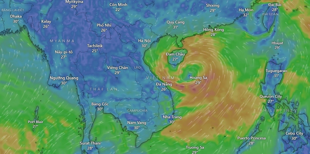
Regarding the tropical depression that is likely to strengthen into a storm in the East Sea, Mr. Mai Van Khiem - Director of the National Center for Hydro-Meteorological Forecasting said: "Currently, there is a tropical depression active in the North East Sea. It is likely to strengthen into a storm and this is the first storm of 2025 in the East Sea and the Northwest Pacific Ocean . The storm is expected to move northwest, towards the waters of the Hoang Sa archipelago. There is a hypothesis that this storm will move towards Guangdong province (China). However, some other hypotheses suggest that this storm will likely deviate west into the Hainan island area (China) and then enter the Gulf of Tonkin of our country".
The Director of the National Center for Hydro-Meteorological Forecasting warned that in the next 24-48 hours, there is a risk of strong winds at sea, affecting maritime activities and fishing of ships, etc. in the central and northern East Sea. There is a risk of thunderstorms and tornadoes from the tropical low pressure circulation, which will then develop into a storm.
Mr. Nguyen Van Huong - Head of the Weather Forecast Department (National Center for Hydro-Meteorological Forecasting) commented: "The characteristics of the tropical depression that is strengthening into a storm in the East Sea are large clouds, covering most of the northern, central and even southern regions of the East Sea. The sea area from Quang Tri to Quang Ngai is affected by the tropical depression circulation, then the circulation of storm No. 1. Therefore, all areas of the northern, central and southern East Sea have strong winds of level 6-7, then increasing to level 8-9. The northern East Sea area has waves from 4-6m high, the central sea area has waves from 2-4m high. The highest scenario for the direction of movement of storm No. 1 is that it may enter the eastern part of the Hainan archipelago (China). We continue to monitor the next scenarios of the storm, including the possibility that the storm will change direction and move into the Gulf of Tonkin".
According to the National Center for Hydro-Meteorological Forecasting, by 7am on June 11, the tropical depression is expected to move west at a speed of about 5km/h and is likely to strengthen. The current location is about 15.6 degrees North latitude and 114.3 degrees East longitude, about 240km East Southeast of Hoang Sa archipelago. The wind speed is level 7, gusting to level 9. The dangerous area in the East Sea with strong winds from level 6 or higher is between 13.0 and 18.5 degrees North latitude and between 112.0 and 118.0 degrees East longitude. The level of natural disaster risk due to strong winds at sea is warned at level 3, affecting the North East Sea area (including Hoang Sa archipelago) and the North of the central East Sea area.
By 7:00 a.m. on June 12, the tropical depression is likely to strengthen into a storm and move in a West-Northwest direction at a speed of 10-15 km/h. At this time, the storm center is located in the Hoang Sa archipelago, at about 16.4 degrees North latitude and 111.6 degrees East longitude. Winds are at level 8-9, gusting to level 11. The danger zone is expanded from 13.5 to 18.5 degrees North latitude and from 109.5 to 117.0 degrees East longitude. The disaster risk level remains at level 3, affecting the northern East Sea, the northern area between the East Sea and offshore waters from Quang Tri to Quang Ngai.
The National Center for Hydro-Meteorological Forecasting said that the storm is likely to change direction, moving to the North-Northwest at a speed of ~10 km/h and is likely to continue to strengthen. Due to the influence of the North East Sea and the North of the central East Sea, there will be thunderstorms, strong winds of level 6-7, gusts of level 9; rough seas, waves 2.0-4.0m high. Ships in the danger zone should be aware of the high risk of thunderstorms, tornadoes, strong winds and large waves.
It is forecasted that the North East Sea (including the Hoang Sa archipelago), the middle and South East Sea (including the Truong Sa archipelago), the sea from Binh Dinh to Ca Mau, Ca Mau to Kien Giang and the Gulf of Thailand will have showers and thunderstorms. During thunderstorms, there is a possibility of tornadoes, strong gusts of wind at level 6-7, and waves over 2.0m high. The sea from Ninh Thuan to Ca Mau, the middle and south East Sea will have strong southwest winds at level 5, sometimes level 6, gusts at level 7-8, rough seas, and waves from 1.5-3.0m high. All vessels operating in the above areas should pay special attention to the high risk of tornadoes, strong gusts of wind and big waves.
The National Center for Hydro-Meteorological Forecasting recommends that authorities, people and forces operating at sea need to regularly monitor updated news, proactively prepare prevention plans and promptly respond to any possible situations.
Proactively respond to tropical depressions
To proactively respond to natural disasters, the Minister of Agriculture and Environment requests ministries, branches, and Chairmen of People's Committees of coastal provinces and cities from Quang Ninh to Khanh Hoa to:
Closely monitor the developments of tropical depression; strictly manage vessels going out to sea; organize counting and notify owners of vessels, captains of ships and boats operating at sea of the location, direction of movement and developments of tropical depression to proactively avoid, escape or not move into dangerous areas. Dangerous areas in the next 24 hours: From 13.0-18.5 degrees North latitude, 112.0-118.0 degrees East longitude (dangerous areas are adjusted in forecast bulletins).
Prepare forces and means for rescue when requested; Voice of Vietnam, Vietnam Television, Vietnam News Agency, coastal information stations and mass media agencies from central to local levels increase information on the developments of natural disasters to authorities at all levels, owners of means of transport operating at sea and people to proactively prevent and respond.
Ministries and branches, according to their functions, state management tasks and assigned tasks, proactively direct and coordinate with localities to respond to natural disasters. The on-duty team must seriously and regularly report to the Ministry of Agriculture and Environment (through the Department of Dyke Management and Natural Disaster Prevention and Control).
According to VOV
Source: https://baothanhhoa.vn/chi-tiet-ve-cuong-do-huong-di-cua-atnd-dang-manh-len-thanh-bao-o-bien-dong-251660.htm


Comment (0)