
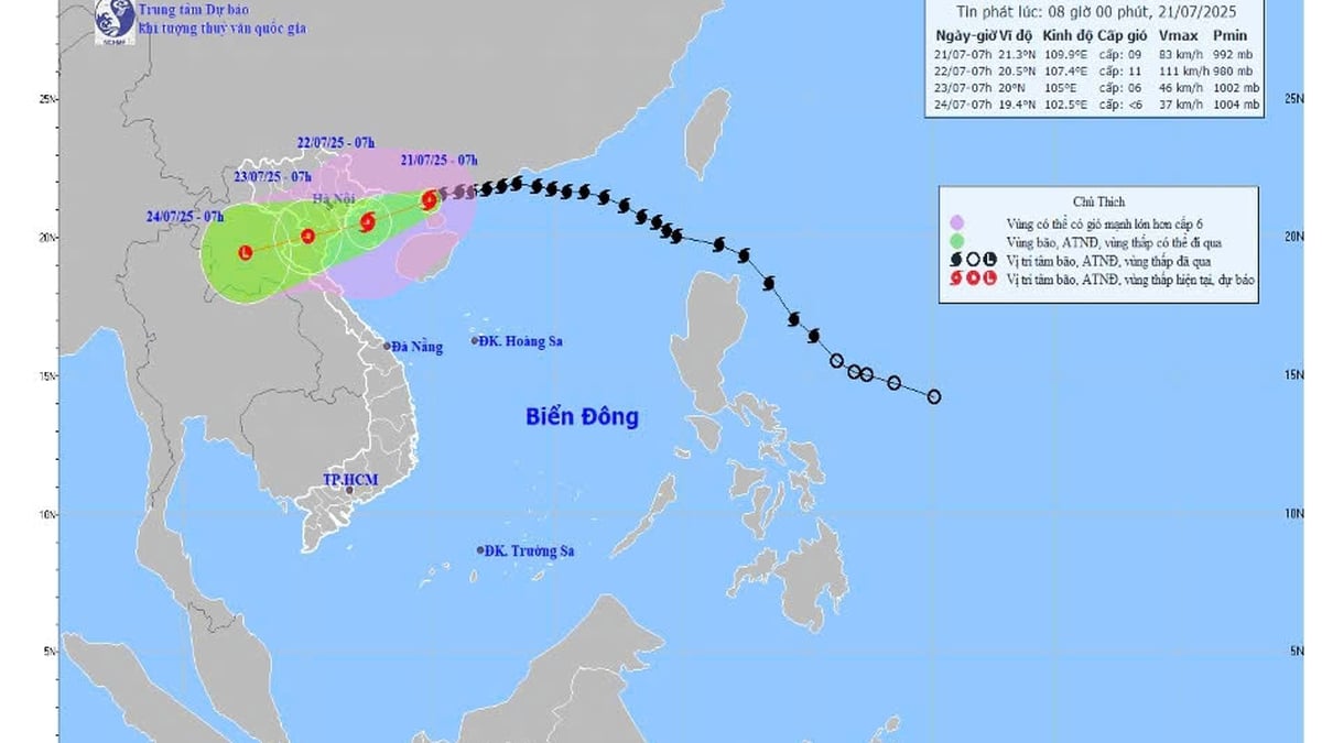
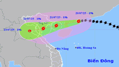
The storm is forecast to make landfall with winds of level 9-10, gusting to level 12.
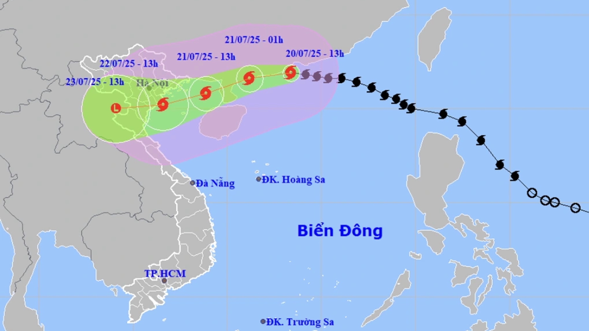
In the next 24 hours, the storm will continue to move west-southwest at a sustained speed of 20-25 km/h. By 4:00 p.m. on July 21, the storm center will approach the northern area of the Gulf of Tonkin, at approximately 20.7 degrees north latitude; 108.5 degrees east longitude. Here, the wind near the storm center will remain at level 11-12, gusting to level 15.
The dangerous area at sea is determined from latitude 19 degrees north and above, within the range of 107.5 to 115.5 degrees east. The level 3 disaster risk warning continues to be maintained for the northwestern area of the East Sea and the entire northern Gulf of Tonkin.
In the next 48 hours, the storm is likely to move further inland, making landfall in the coastal areas of Hai Phong - Thanh Hoa provinces. It is forecasted that by 4pm on July 22, the storm's center will be on land, at about 20.2 degrees north latitude; 106.2 degrees east longitude. Wind speed will decrease to level 9 - 10, gusting to level 12. The entire coastal area from Quang Ninh to Nghe An is within the direct impact range.
After making landfall, the storm weakened into a tropical depression.
Over the next 72 hours, the storm will move west-southwest at a slower speed of about 10-15 km/h and gradually weaken. By 4:00 p.m. on July 23, the center of the low pressure area was located over upper Laos (19.8 degrees north latitude; 103.8 degrees east longitude), with winds dropping below level 6.
Despite weakening, the danger zone at sea still extends north of the 18th parallel and west of the 108th parallel. The level 3 disaster risk warning continues to apply to the Gulf of Tonkin, coastal areas and mainland from Quang Ninh to Nghe An .
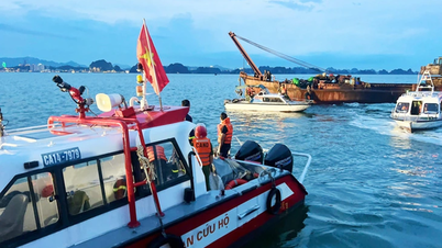
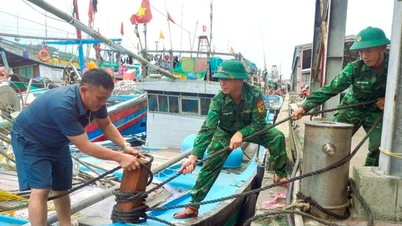
The sea is rough, ships need to take shelter immediately.
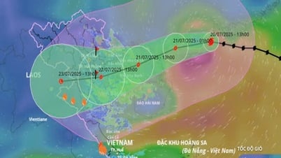
The marine weather forecast shows that the northwestern part of the East Sea will have strong winds of level 8-10, near the storm center of level 11-12, gusts of level 15, waves of 5-7 m high, and rough seas. From the night of July 20, the wind began to increase strongly in the northern part of the Gulf of Tonkin (including Bach Long Vi, Co To, Cat Hai, Hon Dau), up to level 6-7, then gradually increasing to level 10-12, gusts of level 15. Waves of 3-5 m high are very dangerous for maritime activities.
The southern Gulf of Tonkin (including Hon Ngu Island) also has strong winds of level 6-7, near the storm center of level 8-9, gusts of level 11, waves 2-4 m high. The meteorological agency warns that these are extremely dangerous weather and oceanographic conditions, tourist boats, passenger boats and transport boats should absolutely not go to sea. There is a high risk of capsizing, damage to aquaculture cages, seriously threatening the lives of fishermen.
Warning of rising sea levels, coastal flooding and widespread heavy rain
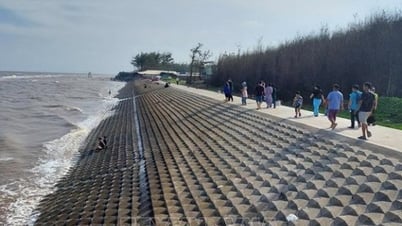
The coastal areas of Hai Phong - Quang Ninh may record a sea level rise of 0.8 - 1.2 m. The forecast water level at Hon Dau (Hai Phong) is 3.8 - 4.2 m, at Cua Ong (Quang Ninh) is 4.8 - 5.2 m, and at Tra Co (Quang Ninh) is 3.8 - 4.4 m. The risk of flooding in coastal areas and river mouths at noon and afternoon on July 22 is very high.
On land, from the evening of July 21, coastal areas from Quang Ninh to Nghe An provinces will have winds gradually increasing to level 7-9, near the storm center level 10-11, gusting to level 14. Inland areas will also have winds of level 6-7, gusting to level 8-9. Strong winds can cause trees and electric poles to fall, roofs to be blown off, and severe damage to infrastructure and property.
From July 21 to 23, the Northeast, the Northern Delta, Thanh Hoa and Nghe An will have heavy to very heavy rain, with rainfall ranging from 200 to 350 mm, locally exceeding 600 mm. Other areas in the North and Ha Tinh will also have heavy rain, with very heavy rain and thunderstorms, with rainfall ranging from 100 to 200 mm, locally exceeding 300 mm.
Special warning of the risk of heavy rain over 150 mm within 3 hours, which can easily cause flash floods, landslides in mountainous areas, and deep flooding in low-lying areas.
Source: https://baonghean.vn/bao-so-3-wipha-huong-vao-dat-lien-tu-hai-phong-den-thanh-hoa-canh-bao-thien-tai-cap-3-tren-dien-rong-10302731.html


![[Photo] National Assembly Chairman Tran Thanh Man visits Vietnamese Heroic Mother Ta Thi Tran](https://vphoto.vietnam.vn/thumb/1200x675/vietnam/resource/IMAGE/2025/7/20/765c0bd057dd44ad83ab89fe0255b783)


Comment (0)