
Storm No. 3 will have level 14 winds when approaching the shore.
Mr. Mai Van Khiem, Director of the National Center for Hydro-Meteorological Forecasting, said that due to the impact of storm No. 3, in Bach Long Vi special zone, there were strong winds of level 8, gusting to level 9; in Co To special zone, there were strong winds of level 6, gusting to level 7.
At 1 p.m. on July 21, the center of the storm was at approximately 21.1 degrees North latitude; 109.1 degrees East longitude, approximately 120km from Quang Ninh, 260km East of Hai Phong ; approximately 280km from Hung Yen, approximately 310km East Northeast of Ninh Binh. The strongest wind near the center of the storm was level 9-10 (75-102km/h), gusting to level 12; moving West Southwest at a speed of 10-15km/h.

At 1:00 a.m. on July 22, the center of the storm was at about 20.7 degrees North latitude - 108.0 degrees East longitude, in the northern area of Bac Bo Gulf. The strongest wind was level 10-11, gusting to level 14. The storm moved west-southwest at a speed of 10-15 km/h and was likely to strengthen.
The dangerous area at sea is defined as the area north of latitude 18.5 degrees North and from longitude 106.0 to 112.0 degrees East. The natural disaster risk level is level 3, applied to the northwestern sea area of the North East Sea, the Gulf of Tonkin, and coastal waters from Quang Ninh to Ninh Binh .
At 1 p.m. the same day, the storm moved closer to the sea area from Hai Phong to Thanh Hoa , at a position of about 20.3 degrees North latitude - 106.6 degrees East longitude. Wind intensity remained unchanged, still maintaining level 10-11, gusting to level 14. The direction of movement continued to be West Southwest, speed 10-15 km/h.
The danger zone has been adjusted to the north of latitude 18.5 degrees north and the west of longitude 110.0 degrees east. The disaster risk level remains at level 3, directly affecting the Gulf of Tonkin, coastal areas and mainland provinces from Quang Ninh to Nghe An.
By 1 p.m. on July 23, the storm had moved deep into the mainland of Upper Laos and weakened into a low pressure area, with its center located at approximately 19.5 degrees North latitude – 103.8 degrees East longitude. Wind strength had dropped below level 6.
Although weakened, the storm's circulation still affects a wide area in the area north of latitude 18.0 degrees North and west of longitude 109.0 degrees East. Natural disaster risk continues to be maintained at level 3 for the Gulf of Tonkin, coastal areas and mainland from Quang Ninh to Nghe An.
The National Center for Hydro-Meteorological Forecasting recommends that localities in the affected areas continue to closely monitor the storm's developments and proactively take measures to prevent and combat natural disasters according to the "4 on-site" motto, ensuring safety for people and vessels operating at sea.
At sea, the northwest sea area of the North East Sea has strong winds of level 7-8, gusts of level 10, waves 3.0-5.0m high, rough seas. The northern sea area of the Gulf of Tonkin (including the special zones of Bach Long Vi, Co To, Van Don, Cat Hai, Hon Dau island) has strong winds of level 6-7, then increasing to level 8-9, the area near the storm center has winds of level 10-11, gusts of level 14, waves 2.0-4.0m high, the area near the storm center has winds of 4.0-6.0m, rough seas. The southern sea area of the Gulf of Tonkin (including Hon Ngu island) has winds gradually increasing to level 6-7, the area near the storm center has winds of level 8-9, gusts of level 11, waves 2.0-4.0m high, very rough seas.
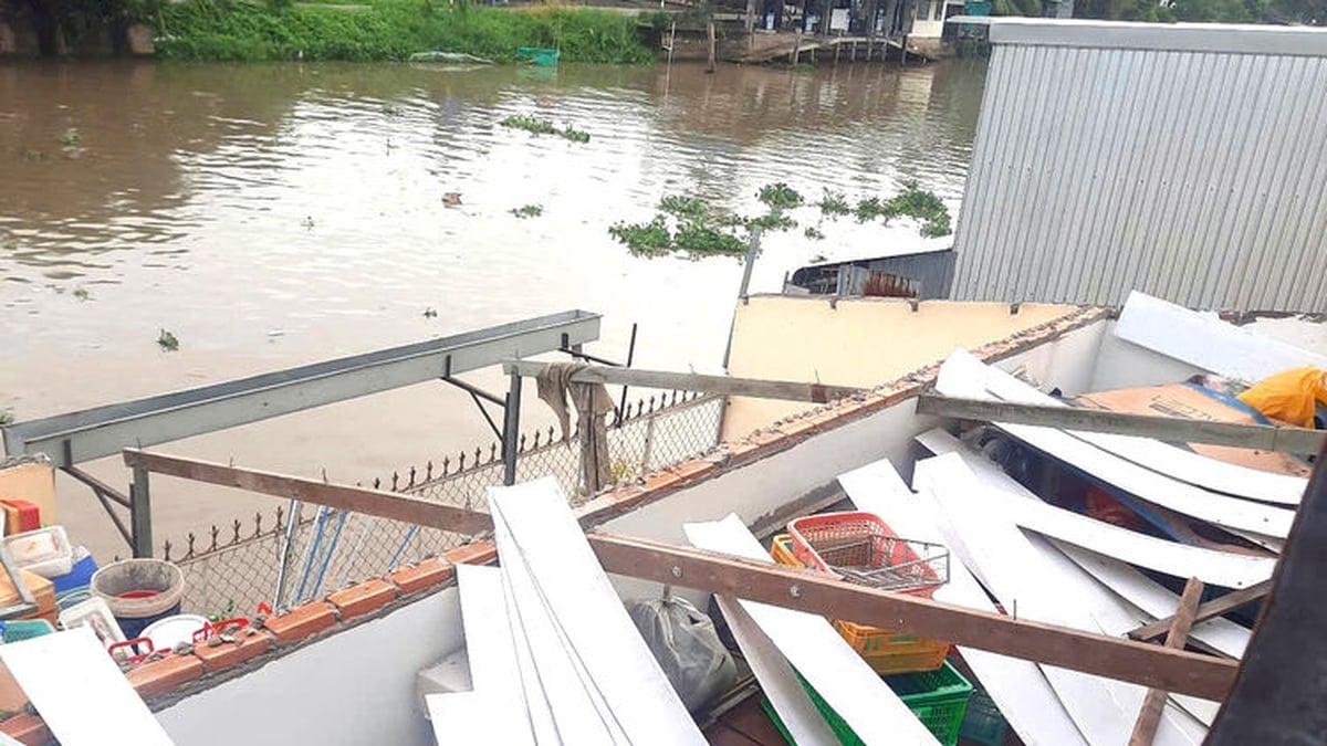
The coastal areas of Hung Yen-Quang Ninh have storm surges of 0.5-1.0m high. Water levels in Ba Lat (Hung Yen) are 2.4-2.6m high, Hon Dau (Hai Phong) are 3.9-4.3m high, Cua Ong (Quang Ninh) are 4.6-5.0m high and Tra Co (Quang Ninh) are 3.6-4.0m high. There is a high risk of flooding in coastal areas and river mouths on the afternoon of July 22.
Experts warn that the weather at sea and in coastal areas during storms is extremely dangerous and unsafe for any vehicles or structures operating in dangerous areas such as: cruise ships, passenger ships, cargo ships, cages, rafts, aquaculture areas, dykes, embankments, and coastal routes. Vehicles are at high risk of capsizing, being destroyed, or being flooded due to strong winds, storms, whirlwinds, large waves, and rising sea levels.
Thunderstorms and whirlwinds from this afternoon
Mr. Mai Van Khiem said that due to the impact of storm No. 3, from the evening and night of July 21, coastal areas from Quang Ninh to Nghe An will have winds gradually increasing to level 7-9, areas near the storm center will have winds of level 10-11, gusting to level 14; inland areas of Hai Phong, Hung Yen, Ninh Binh and Thanh Hoa provinces/cities, winds will be strong at level 6, gusting to level 7-8. Winds of level 10-11 can knock down trees, electric poles, and roofs, causing very serious damage. The level of impact according to wind level is detailed in Appendix 1.
From July 21 to July 23, in the Northeast region, the Northern Delta, Thanh Hoa and Nghe An, there will be heavy to very heavy rain and thunderstorms with common rainfall of 200-350mm, locally over 600mm; other places in the Northern region and Ha Tinh will have moderate rain, heavy rain, locally very heavy rain and thunderstorms with common rainfall of 100-200mm, locally over 300mm. Warning of the risk of heavy rain (>150mm/3h). Heavy rain in a short period of time can cause flash floods, landslides in mountainous areas, and flooding in low-lying areas.
In addition, heavy rain will cause rivers in the North, Thanh Hoa, and Nghe An to experience a flood with an amplitude of 3-6 m from tonight until July 25. Small rivers, Thao River, and the upper Ma River may reach alert levels two and three. The Lo, Da, Cau, Thuong, Luc Nam, Hoang Long Rivers and the upper Ca River are forecast to reach alert levels one and two, and in some places exceed alert level two. The lower reaches of the Red River and Thai Binh River are below alert level one; the lower reaches of the Ma River and Ca River fluctuate around alert level one.
Source: https://baolaocai.vn/bao-so-3-vua-tang-len-1-cap-va-con-manh-them-mua-lon-nhat-tap-trung-vao-dem-nay-va-sang-mai-post649358.html


![[Photo] National Assembly Chairman Tran Thanh Man visits Vietnamese Heroic Mother Ta Thi Tran](https://vphoto.vietnam.vn/thumb/1200x675/vietnam/resource/IMAGE/2025/7/20/765c0bd057dd44ad83ab89fe0255b783)


Comment (0)