
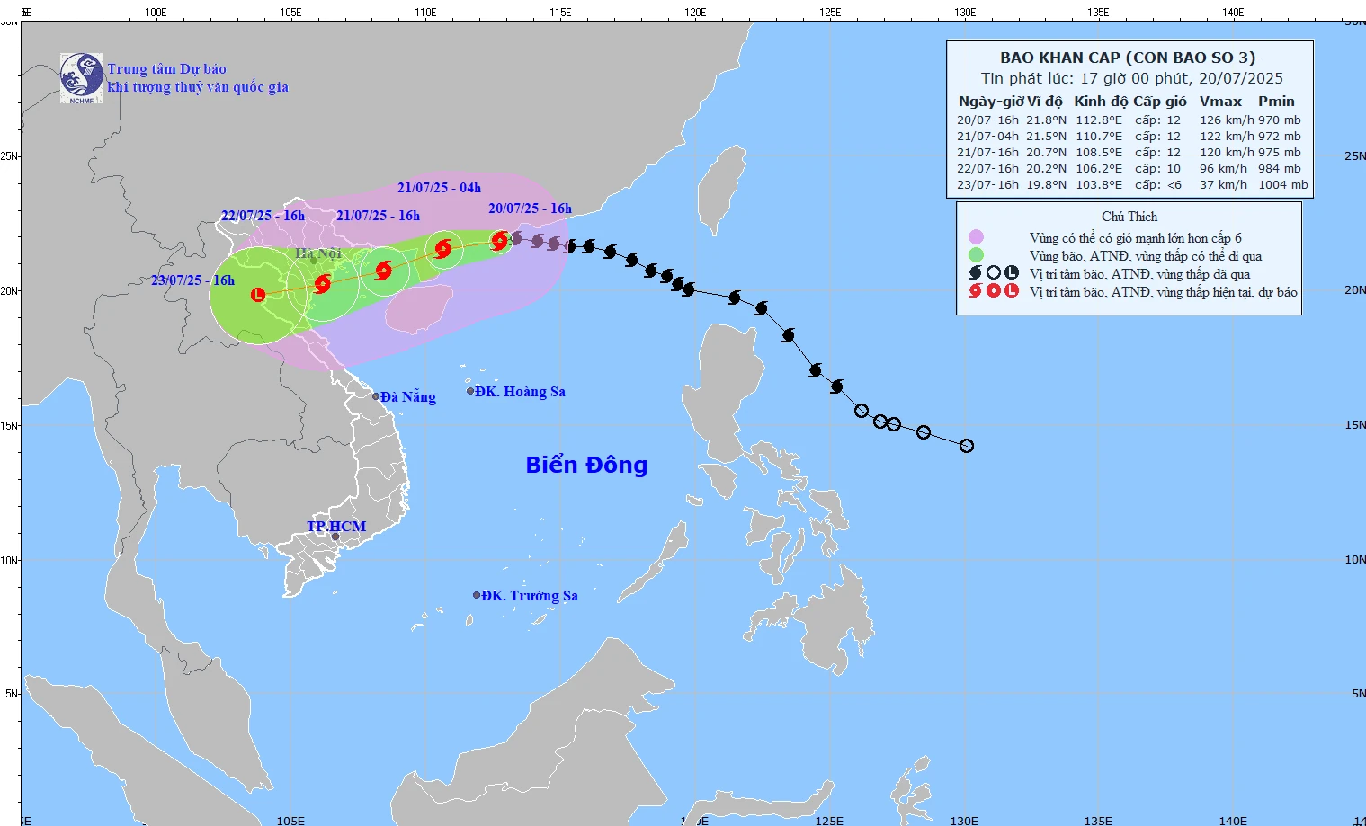
The path of storm No. 3 according to the bulletin issued at 5:00 p.m. on July 20 by the National Center for Hydro-Meteorological Forecasting.
According to the National Center for Hydro-Meteorological Forecasting, at 4:00 p.m. on July 20, the storm's center was at about 21.8 degrees North latitude; 112.8 degrees East longitude, in the northern sea area of the North East Sea, about 560 km east of Quang Ninh - Hai Phong . The strongest wind was level 12 (118-133 km/h), gusting to level 15. The storm moved westward at a speed of 20-25 km/h.
Forecast by 4:00 p.m. on July 21, the storm is in the northern Gulf of Tonkin, level 11-12, gust level 15.
At 4:00 p.m. on July 22, the storm made landfall along the coast of Hai Phong - Thanh Hoa , weakening to level 9-10, with gusts of level 12.
At 4:00 p.m. on July 23, the storm was in the Upper Laos region and weakened into a low pressure area.
Due to the impact of storm No. 3, the northwestern sea area of the North East Sea has winds of level 8-10, near the storm center winds of level 11-12, gusts of level 15, waves 5-7m high, and rough seas.
From the night of July 20, the wind in the northern Gulf of Tonkin gradually increased to level 6-7, then increased to level 8-9, near the storm center level 10-12, gusts level 15; waves 3-5m high. The southern Gulf of Tonkin had strong winds of level 6-7, near the storm center level 8-9, gusts level 11, waves 2-4m high.
On land, from the night of July 21, the coast from Quang Ninh to Nghe An will have winds of level 7-9, near the storm center, winds of level 10-11, gusting to level 14; deep inland, winds of level 6-7, gusting to level 8-9.
The meteorological agency has advised ships not to operate in areas affected by the storm. People in coastal areas from Quang Ninh to Nghe An should complete reinforcing their houses and evacuate if necessary before July 21.
NDS
Source: https://baothanhhoa.vn/bao-so-3-giat-cap-15-vung-ven-bien-quang-ninh-nghe-an-di-doi-dan-neu-can-thiet-truoc-ngay-21-7-255451.htm


![[Photo] National Assembly Chairman Tran Thanh Man visits Vietnamese Heroic Mother Ta Thi Tran](https://vphoto.vietnam.vn/thumb/1200x675/vietnam/resource/IMAGE/2025/7/20/765c0bd057dd44ad83ab89fe0255b783)


Comment (0)