


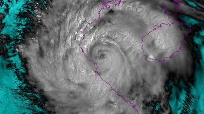
News about tropical depression in the East Sea. Photo: nchmf.gov.vn
At 4:00 a.m., the center of the tropical depression was at about 15.7 degrees North latitude; 115.7 degrees East longitude, about 360 km East Southeast of the Hoang Sa area. The strongest wind near the center of the tropical depression was level 6 (39-49 km/h), gusting to level 8; the tropical depression moved slowly to the West at a speed of about 5 km/h.
It is forecasted that by 4:00 a.m. on June 11, the tropical depression will be located about 240 km east-southeast of the Hoang Sa area with strong winds of level 6-7, gusts of 9; the tropical depression will move west at a speed of about 5 km/h and is likely to strengthen. The affected areas are the northern East Sea (including the Hoang Sa area) and the northern sea area of the central East Sea. Disaster risk warning level 3.
At 4:00 a.m. on June 12, the tropical depression moved in a West-Northwest direction at a speed of 10-15 km/h over the Hoang Sa area with strong winds of level 8-9, gusting to level 11 and likely to strengthen into a storm. The affected areas are the North East Sea (including the Hoang Sa area), the sea area north of the central East Sea area and the offshore waters from Hue to Quang Ngai . Disaster risk warning level 3.
Warning, in the next 48 to 72 hours, the storm is likely to change direction and move in the North-Northwest direction at a speed of about 10km/hour and is likely to strengthen.
Due to the influence of the tropical depression, the North East Sea area, the North of the central East Sea area has thunderstorms and strong winds of level 6-7, gusting to level 9, rough seas, waves 2-4m high.
Ships operating in the above mentioned dangerous areas are likely to be affected by storms, whirlwinds, strong winds and large waves.
Tra Vinh Online Newspaper
Source: https://www.baotravinh.vn/trong-nuoc/vung-ap-thap-da-manh-len-thanh-ap-thap-nhiet-doi-tren-bien-dong-46669.html


![[Photo] Multi-colored cultural space at the Exhibition "80 years of the journey of Independence - Freedom - Happiness"](https://vphoto.vietnam.vn/thumb/1200x675/vietnam/resource/IMAGE/2025/8/26/fe69de34803e4ac1bf88ce49813d95d8)
![[Photo] Hanoi: Authorities work hard to overcome the effects of heavy rain](https://vphoto.vietnam.vn/thumb/1200x675/vietnam/resource/IMAGE/2025/8/26/380f98ee36a34e62a9b7894b020112a8)


Comment (0)