
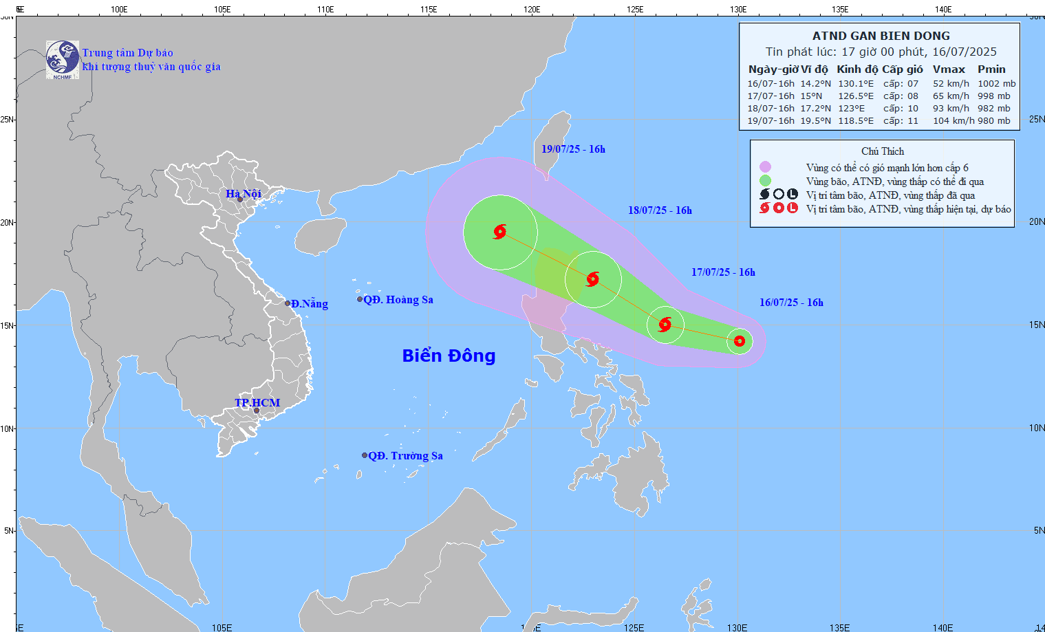
According to the National Center for Hydro-Meteorological Forecasting, at 4:00 p.m. on July 16, the center of the tropical depression was located in the sea east of the Philippines. The strongest wind near the center of the tropical depression was level 6-7 (39-61 km/h), gusting to level 9; moving west-northwest at a speed of about 15 km/h.
It is forecasted that in the next 24 hours, the tropical depression will continue to move in a West-Northwest direction at a speed of 15-20km/h. By 4pm on July 17, the center of the tropical depression will be in the sea east of the northern Philippines. It is forecast to strengthen into a storm, with a level 8 intensity and gusts of level 10.
In the next 24 hours, the storm will continue to move northwest at a speed of about 20km/h. At 4pm on July 18, the center of the storm will be in the sea east of Luzon Island (Philippines) with a level 10 intensity, gusting to level 12, and is likely to strengthen.
From the next 48 to 72 hours, the storm will continue to move mainly in the West-Northwest direction, traveling 20-25km per hour and is likely to strengthen as it approaches the East Sea.
Meteorological experts say that after strengthening into a storm in the northern area of Luzon Island (Philippines), the storm that has strengthened from this tropical depression will pass over the northern area of Luzon Island (Philippines) and enter the East Sea on the weekend (July 19-20).
The dominant atmospheric systems such as the southwest monsoon, subtropical high pressure... are still fluctuating and unstable, causing the trajectory and intensity of this system to potentially fluctuate. When it strengthens into a storm and moves into the East Sea, the storm may move west-northwest, towards the northern Gulf of Tonkin in the coming days with a probability of about 50-60%.
With the scenario of moving West Northwest and if heading towards the mainland of our country, be on guard for the risk of widespread heavy rain in the Northern region and provinces from Thanh Hoa to Nghe An in the period from July 20-25, 2025.
Rainfall developments are still very complicated, depending on the direction of movement and impact of tropical depressions/storms.
The National Center for Hydro-Meteorological Forecasting is closely monitoring the above developments and promptly updating bulletins to serve the direction and response work of all levels and sectors.
KT (according to Vietnamnet)Source: https://baohaiphongplus.vn/tin-moi-nhat-ve-ap-thap-nhiet-doi-gan-bien-dong-416510.html


![[Maritime News] More than 80% of global container shipping capacity is in the hands of MSC and major shipping alliances](https://vphoto.vietnam.vn/thumb/402x226/vietnam/resource/IMAGE/2025/7/16/6b4d586c984b4cbf8c5680352b9eaeb0)


Comment (0)