

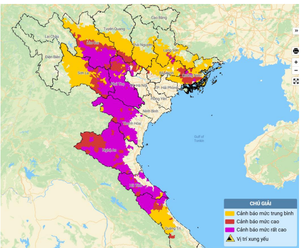
Map of flash flood and landslide risk in the areas.
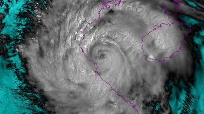
In the past 24 hours (from 12:00 on August 25 to 12:00 on August 26), the provinces of Son La, Lao Cai, Tuyen Quang, Phu Tho, Thai Nguyen, Bac Ninh , Lang Son, Quang Ninh and from Thanh Hoa to Quang Tri had moderate rain, heavy rain to very heavy rain such as: Muong Do1 268mm (Son La); Cao Pha3 358.6mm (Lao Cai); Van Mai 551.8mm (Phu Tho); My Yen 118.4mm (Thai Nguyen); Dong Loi 97.4mm (Tuyen Quang); Tan Son 157.4mm (Bac Ninh); Chi Lang 160.6mm (Lang Son); Ky Thuong 300.2mm (Quang Ninh); Van Xuan1 557mm (Thanh Hoa); Hua Na Hydropower Plant 444.4mm (Nghe An); Ky Phong 393.2mm (Ha Tinh); Hoa Son 191mm (Quang Tri);... Soil moisture models show that some areas in the above provinces are nearly saturated (over 85%) or have reached saturation.
In the next 3-6 hours, the above provinces will continue to have rain with common accumulated rainfall as follows: Lao Cai, Phu Tho, Son La, Thanh Hoa from 30-70mm, some places over 120mm; Quang Ninh, Lang Son, Bac Ninh, Thai Nguyen, Tuyen Quang, Nghe An from 20-40mm, some places over 70mm; Ha Tinh and Quang Tri from 5-15mm, some places over 30mm.
In the next 12 hours, there is a risk of flash floods on small rivers and streams, and landslides on steep slopes in many communes/wards.
Warning level of natural disaster risk due to flash floods, landslides, land subsidence due to rain, floods or water flow: Level 1.
Phu Tho, Thanh Hoa, Nghe An and Ha Tinh are level 2.
List of communes in Thanh Hoa province warned of the risk of flash floods on small rivers and streams, landslides on steep slopes within 6 hours (from 12:00 to 18:00 on August 26): Ba Thuoc, Cam Tan, Cam Thach, Cam Thuy, Cam Tu, Cam Van, Co Lung, Cong Chinh, Dien Lu, Dien Quang, Dong Luong, Giao An, Hien Kiet, Hoa Quy, Hoi Xuan, Hop Tien, Kien Tho, Linh Son, Luan Thanh, Luong Son, Mau Lam, Minh Son, Muong Chanh, Muong Lat, Muong Ly, Muong Min, Nam Xuan, Ngoc Lac, Ngoc Lien, Ngoc Trao, Nguyet An, Nhi Son, Nhu Thanh, Nhu Xuan, Phu Le, Phu Xuan, Pu Luong, Pu Nhi, Quan Son, Quang Chieu, Quy Luong, Son Dien, Son Thuy, Tam Chung, Tam Lu, Tam Thanh, Tan Thanh, Tay Do, Thach Binh, Thach Lap, Thach Quang, Thang Loc, Thanh Ky, Thanh Phong, Thanh Quan, Thanh Vinh, Thien Phu, Thiet Ong, Thuong Ninh, Thuong Xuan, Trung Ha, Trung Ly, Trung Son, Trung Thanh, Truong Lam, Van Du, Van Nho, Van Phu, Van Xuan, Xuan Binh, Xuan Chinh, Xuan Du, Xuan Thai, Xuan Tin, Yen Ginger, Yen Nhan, Yen Phu, Yen Thang, Yen Tho; Bat Mot; Na Meo. | |
LP
Source: https://baothanhhoa.vn/thanh-hoa-co-nguy-co-cao-xay-ra-lu-quet-sat-lo-dat-trong-6-gio-toi-259610.htm

![[Photo] Multi-colored cultural space at the Exhibition "80 years of the journey of Independence - Freedom - Happiness"](https://vphoto.vietnam.vn/thumb/1200x675/vietnam/resource/IMAGE/2025/8/26/fe69de34803e4ac1bf88ce49813d95d8)

![[Photo] Hanoi: Authorities work hard to overcome the effects of heavy rain](https://vphoto.vietnam.vn/thumb/1200x675/vietnam/resource/IMAGE/2025/8/26/380f98ee36a34e62a9b7894b020112a8)


Comment (0)