
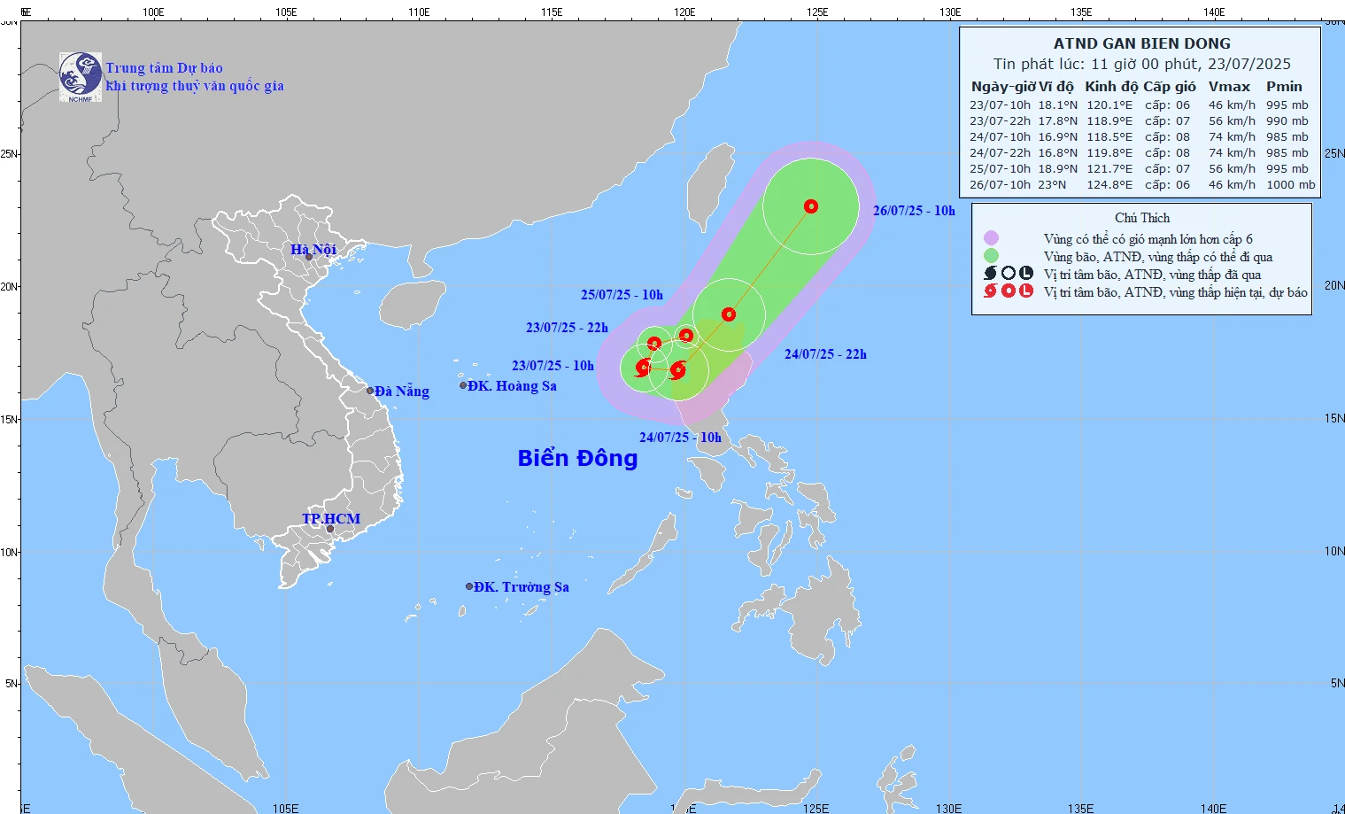
At 10:00 a.m. on July 23, the center of the tropical depression was at about 18.1 degrees North latitude; 120.1 degrees East longitude, in the sea northwest of Luzon Island (Philippines).
The strongest wind near the center of the tropical depression is level 6 (39-49 km/h), gusting to level 8; the tropical depression moves in the West Southwest direction at a speed of about 15 km/h.
It is forecasted that by 10:00 p.m. on July 23, the tropical depression in the eastern sea of the North East Sea will move in a West-Southwest direction at a speed of about 10-15 km/h and is likely to strengthen.
The strongest wind is level 7, gusting to level 9. The affected area is the sea area east of the North East Sea. Natural disaster risk level 3.
At 10:00 a.m. on July 24, the tropical depression in the eastern sea of the North East Sea, moving in the South-Southwest direction at a speed of about 5-10 km/h and is likely to strengthen into a storm.
The strongest wind is level 8, gusting to level 10. The affected area is the sea area east of the North East Sea. Natural disaster risk level 3.
At 10:00 p.m. on July 24, the tropical depression in the eastern sea of the North East Sea was moving eastward at a speed of about 10 km/h. The strongest wind was level 8, gusting to level 10. The affected area was the eastern sea of the North East Sea. The disaster risk level was level 3.
At 10:00 a.m. on July 25, the tropical depression in the northern sea of Luzon Island (Philippines) moved eastward at a speed of about 20-25 km/h. The strongest wind was level 7, gusting to level 9. The affected area was the eastern sea of the North East Sea. Disaster risk level 3.
From the next 48 to 72 hours, the storm will move mainly in the Northeast direction, traveling 20-25 km per hour and gradually weaken into a tropical depression.
Due to the impact of the tropical depression, the eastern sea of the North East Sea has strong winds of level 6-7, near the storm center strong winds of level 8, gusting to level 10; waves 2-3.5m high, rough seas.
Ships operating in the above mentioned dangerous areas are likely to be affected by storms, whirlwinds, strong winds and large waves.
NDS
Source: https://baothanhhoa.vn/sau-bao-ap-thap-nhiet-doi-lai-xuat-hien-tien-sat-bien-dong-nuoc-ta-255831.htm


Comment (0)