


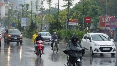
From September 1 to September 5, thunderstorms are likely to occur in the late afternoon and at night in the Northern and Central regions. (Photo: Duy Khuong/VNA)
According to the National Center for Hydro-Meteorological Forecasting, on the night of August 27 and August 28, the sea area from Lam Dong to Ho Chi Minh City, the central and southern East Sea (including Truong Sa archipelago) will have southwest winds of level 6, gusting to level 7-8; rough seas. The eastern sea area of the northern East Sea will have strong winds of level 6-7, gusting to level 9; rough seas. Waves will be 2-3.5m high in the southern East Sea and 2-4m high in the northern East Sea.
In addition, on the night of August 27 and August 28, the Gulf of Tonkin, the sea area from South Quang Tri to Ca Mau, Ca Mau to Kien Giang , the Gulf of Thailand, the North, Central and South East Sea (including Hoang Sa and Truong Sa archipelagos) will have scattered showers and thunderstorms. During thunderstorms, there is a possibility of tornadoes, strong gusts of wind of level 6-7 and waves over 2m high.
The National Center for Hydro-Meteorological Forecasting recommends that on the night of August 28 and August 29, the sea area from Lam Dong to Ho Chi Minh City, the central and southern East Sea (including Truong Sa archipelago) will have strong southwest winds of level 6, gusting to level 7-8; waves 2.0-3.5m high; rough seas.
The North East Sea area (including Hoang Sa archipelago) has strong winds of level 7, gusting to level 9; waves 2-4m high; rough seas.
Accordingly, all vessels operating in the above areas are at high risk of being affected by tornadoes, strong winds and large waves. Level 2 natural disaster risk due to strong winds at sea. Particularly, the sea area east of the North East Sea is level 3.
In the next 6 hours, the National Center for Hydro-Meteorological Forecasting also warns of the risk of flash floods, landslides, and land subsidence on steep slopes and small streams in Quang Ngai in the areas of Ba Vi, Ba Xa; Ba Dinh, Ba To, Ba To, Ba Vinh, Minh Long, Son Ha, Son Ha, Son Ky, Son Linh, Son Tay, Son Tay Ha, Son Tay Thuong, Son Thuy; in Gia Lai, the areas of An Hao, An Hoa, Binh Hiep, Hoa Hoi, Hoi Son, Van Duc, Vinh Thinh.
In the evening and night of August 27, in the North and the area from Thanh Hoa to Ha Tinh, there will be showers and thunderstorms, locally heavy rain with common rainfall of 20-40mm, in some places over 100mm.
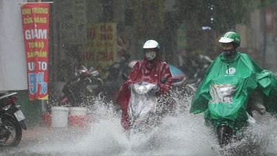
Also, in the afternoon and evening of August 27, from Quang Tri to Lam Dong and the South, there are forecasts of scattered showers and thunderstorms, locally heavy rain with rainfall of 10-30mm, some places over 80mm. There is a risk of localized rain with intensity greater than 80mm/3 hours.
During thunderstorms, there may be: tornadoes, lightning, hail, strong gusts of wind. Localized heavy rain can cause flash floods on small rivers and streams; landslides on steep slopes; flooding in low-lying areas.
According to the National Center for Hydro-Meteorological Forecasting, on the night of August 27 and August 28, areas across the country will continue to experience showers and thunderstorms, with some areas experiencing heavy to very heavy rain. Thunderstorms may include tornadoes, lightning, hail, and strong gusts of wind.
Hanoi area:
-The lowest temperature is from 24-26°C, the highest is from 29-31°C, some places are above 31°C.
-Cloudy, occasional showers and thunderstorms, concentrated at night and morning. Light wind.
Northwest:
-The lowest temperature is from 22-25°C, in some places below 21°C; the highest is from 28-31°C.
-Cloudy, scattered showers and thunderstorms, locally heavy to very heavy rain. Light wind.
Northeastern region:
-The lowest temperature is from 23-26°C, the highest is from 29-32°C.
-Cloudy, scattered showers and thunderstorms, locally heavy to very heavy rain, concentrated at night and morning.
-Southeast to East wind level 2-3.
Provinces from Thanh Hoa to Hue city:
-The lowest temperature is from 23-26°C, the highest is from 29-32°C, some places are above 32°C.
-Cloudy, scattered showers and thunderstorms, locally heavy to very heavy rain. Light wind.
South Central Coast Region:
-The lowest temperature is from 25-28°C, the highest is from 31-34°C.
-Cloudy, intermittent sunshine during the day, scattered showers and thunderstorms in the afternoon and evening, locally heavy rain in some places.
-Southwest wind level 2-3.
In the Central Highlands region:
-The lowest temperature is from 19-22°C, the highest is from 25-28°C, some places are above 28°C.
-Cloudy, intermittent sunshine during the day, scattered showers and thunderstorms in the afternoon and evening, locally heavy rain.
-Southwest wind level 2-3.
Southern region:
-The lowest temperature is from 24-27°C, the highest is from 30-33°C, some places are above 33°C.
-Cloudy, intermittent sunshine during the day, scattered showers and thunderstorms in the afternoon and evening, locally heavy rain.
-Southwest wind level 2-3.
Ho Chi Minh City:
-The lowest temperature is from 24-26°C, the highest is from 31-33°C.
-Cloudy, with scattered showers and thunderstorms in some places; in the afternoon and evening there will be scattered showers and thunderstorms, with heavy rain in some places.
-Southwest wind level 2-3./.
According to Vietnamplus
Source: https://www.vietnamplus.vn/nhieu-khu-vuc-mua-dong-ve-dem-va-sang-de-phong-loc-set-gio-giat-manh-post1058302.vnp
Source: https://baolongan.vn/nhieu-khu-vuc-mua-dong-ve-dem-va-sang-de-phong-loc-set-gio-giat-manh-a201477.html

![[Photo] Parade blocks pass through Hang Khay-Trang Tien during the preliminary rehearsal](https://vphoto.vietnam.vn/thumb/1200x675/vietnam/resource/IMAGE/2025/8/27/456962fff72d40269327ac1d01426969)


![[Photo] Images of the State-level preliminary rehearsal of the military parade at Ba Dinh Square](https://vphoto.vietnam.vn/thumb/1200x675/vietnam/resource/IMAGE/2025/8/27/807e4479c81f408ca16b916ba381b667)


Comment (0)