

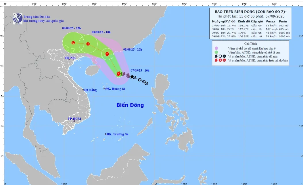
Forecast map of storm trajectory and intensity at 11:00 a.m. on September 7, 2025. (Photo: KTTV)
According to the National Center for Hydro-Meteorological Forecasting, at 10:00 a.m. on September 7, the center of storm No. 7 was located at about 18.7 degrees North latitude; 114.1 degrees East longitude, in the northern sea area of the North East Sea. The strongest wind near the center of the storm was level 9 (75 - 88 km/h), gusting to level 11. The storm moved west at about 10 km/h.
It is forecasted that by 10am tomorrow morning (September 8), the storm's intensity may reach level 10, gusting to level 13, and it will make landfall in Guangdong province, China. After that, the storm will move west-northwest and weaken into a low pressure area in Guangxi province, China - near the border of our country.
In the next 24 hours, the dangerous area at sea is north of latitude 17.5 degrees North; longitude 111 to 117 degrees East.
Due to the influence of the storm, the northern sea area of the North East Sea has strong winds of level 7 - 8, near the storm center strong winds of level 9 - 10, gusts of level 13; waves 3 - 5 m high, very rough seas.
Ships operating in the above mentioned dangerous areas are likely to be affected by storms, whirlwinds, strong winds and large waves.
The Gulf of Tonkin and coastal areas of the North need to be on guard against thunderstorms, tornadoes and strong gusts of wind.
From the afternoon of September 9 to September 11, the circulation after the storm will cause moderate to heavy rain in the mountainous and midland areas of the North. Warning of the risk of floods, flash floods, landslides, and inundation.
Source vtv.vn
Source: https://baophutho.vn/hoan-luu-sau-bao-so-7-gay-mua-to-o-bac-bo-tu-9-9-11-9-239268.htm


![[Photo] Amazing total lunar eclipse in many places around the world](https://vphoto.vietnam.vn/thumb/1200x675/vietnam/resource/IMAGE/2025/9/8/7f695f794f1849639ff82b64909a6e3d)

![[Photo] Reviving memories of ancient Mid-Autumn lanterns](https://vphoto.vietnam.vn/thumb/1200x675/vietnam/resource/IMAGE/2025/9/8/d17f9089e4d6492eb7745c74f271a250)


Comment (0)