

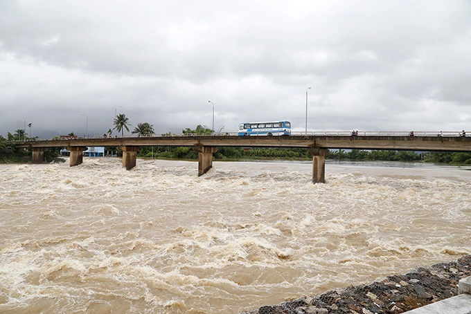
Illustration photo.
Currently, floods on Thao River (Lao Cai), Hoang Long River (Ninh Binh), downstream Ma River (Thanh Hoa), downstream Ca River (Nghe An) are receding. Floods on Thuong River, Cau River ( Bac Ninh ) are rising; on Luc Nam River (Bac Ninh) are fluctuating above warning level (BĐ)1.
Water levels at 7:00 a.m. on August 28 on rivers are as follows:
On Thao River at Yen Bai station 29.93m, below BĐ1 0.07m;
On Luc Nam River at Luc Nam station 4.61m, on BĐ1 0.31m;
On Thuong River at Phu Lang Thuong station 5.18m, below BĐ2 0.12m;
On Cau River at Dap Cau station 4.85m, below BĐ2 0.45m;
On Hoang Long River at Ben De station 3.82m, below BĐ3 0.18m;
On Buoi River at Kim Tan station 13.04m, on BD3 1.04m;
On Chu River at Xuan Khanh station 7.14m, below BĐ1 1.86m;
On Ma River at Ly Nhan station 8.70m, below BĐ1 0.80m; at Giang station 4.90m, below BĐ2 0.60m;
On Ca River at Nam Dan station 5.36m, below BĐ1 0.04m
There is a high risk of flooding in low-lying areas along rivers and landslides on steep slopes in the provinces of Bac Ninh, Ninh Binh, Thanh Hoa, and Nghe An (Real-time warning information on areas at risk of flash floods and landslides is provided online on the website of the Department of Hydrometeorology at: https://luquetsatlo.nchmf.gov.vn and in a separate bulletin warning of flash floods and landslides).
Flood disaster risk warning level: Level 1
Flood impact warning: River floods cause inundation of low-lying areas along the river, affecting activities such as water transport, aquaculture, agricultural production, people's lives and socio-economic activities.
LP
Source: https://baothanhhoa.vn/ha-muc-canh-bao-lu-tren-song-ma-xuong-duoi-bao-dong-i-259852.htm

![[Photo] General Secretary To Lam attends the opening ceremony of the National Achievements Exhibition](https://vphoto.vietnam.vn/thumb/1200x675/vietnam/resource/IMAGE/2025/8/28/d371751d37634474bb3d91c6f701be7f)
![[Photo] Prime Minister Pham Minh Chinh meets with Speaker of the New Zealand Parliament Gerry Brownlee](https://vphoto.vietnam.vn/thumb/1200x675/vietnam/resource/IMAGE/2025/8/28/cec2630220ec49efbb04030e664995db)
![[Photo] Politburo works with the Standing Committee of Cao Bang Provincial Party Committee and Hue City Party Committee](https://vphoto.vietnam.vn/thumb/1200x675/vietnam/resource/IMAGE/2025/8/28/fee8a847b1ff45188749eb0299c512b2)
![[Photo] General Secretary To Lam presents the 45-year Party membership badge to comrade Phan Dinh Trac](https://vphoto.vietnam.vn/thumb/1200x675/vietnam/resource/IMAGE/2025/8/28/e2f08c400e504e38ac694bc6142ac331)
![[Photo] Red flag with yellow star flutters in France on National Day September 2](https://vphoto.vietnam.vn/thumb/1200x675/vietnam/resource/IMAGE/2025/8/28/f6fc12215220488bb859230b86b9cc12)


Comment (0)