

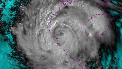
At 1pm this afternoon (August 26), this low pressure area is over the eastern part of the Philippines. It is forecasted that in the next 24-36 hours (from 1pm on August 26), the low pressure area will move West-Northwest, traveling about 15-20km per hour, entering the eastern sea area of the North East Sea and is likely to strengthen into a tropical depression.
Due to the influence of the low pressure circulation (which may later strengthen into a tropical depression around August 27-28), the northern and central East Sea (including the Hoang Sa special zone) will have increasingly strong winds and bad weather. Ships operating in the above areas should take precautions to ensure safety.
Because the low pressure area has not yet strengthened into a tropical depression and has not yet entered the East Sea, the development is still unpredictable. The National Center for Hydro-Meteorological Forecasting reminds people to regularly update the latest forecast bulletins.
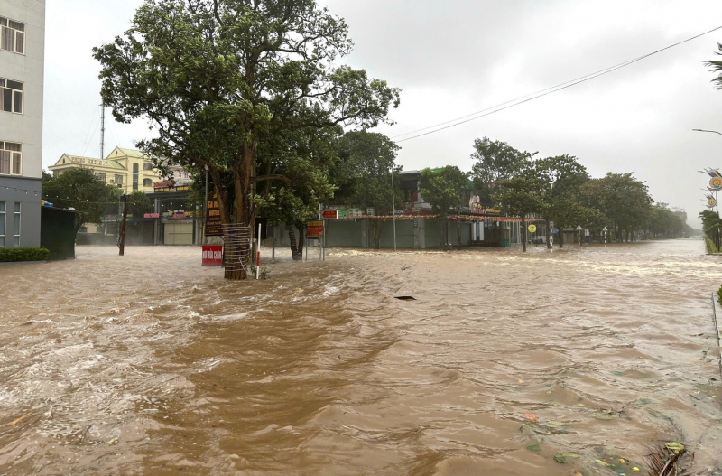
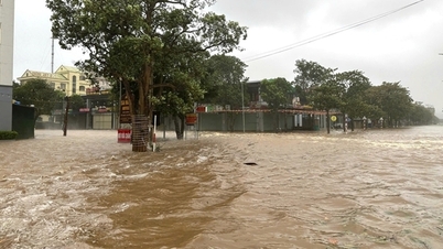
On land today, the circulation of storm No. 5 continues to cause heavy rain in the Northern Delta, Phu Tho, Son La, Lao Cai and Thanh Hoa. Rainfall from 7am to 3pm today in some places was over 140mm such as An Luong station (Lao Cai) 183.6mm, Phu Tho Irrigation Sub-Department station (Phu Tho) 158.2mm, Na Meo station (Thanh Hoa) 142mm.
It is forecasted that from the evening of August 26 to noon of August 27, the midlands and deltas of the North, Son La , Lao Cai, Thanh Hoa will have moderate rain, heavy rain and thunderstorms with common rainfall of 50-100mm, some places will have very heavy rain over 200mm. Rain will appear in waves.
In addition, in the evening and night of August 26, other places in the North will have rain, moderate rain and scattered thunderstorms with rainfall of 20-40mm, locally over 100mm.
From Nghe An to Ha Tinh, the Central Highlands and the South, this evening and tonight there will be showers and thunderstorms with rainfall of 10-30mm, with some places experiencing heavy rain of over 70mm. There is a possibility of tornadoes, lightning, hail and strong gusts of wind during thunderstorms.
Due to prolonged heavy rain, on the afternoon of August 26, floods rose on Thao River (Lao Cai), Luc Nam River (Bac Ninh), Hoang Long River (Ninh Binh) and Ma River system (Thanh Hoa), especially on the upper reaches of Ca River (Nghe An), floods are receding.
The water level at 1:00 p.m. on August 26 on Thao River at Yen Bai station was 29.32m, below alarm level 1, on Luc Nam River (Bac Ninh) at Luc Nam station below alarm level 1, Hoang Long River at Ben De station above alarm level 2, Chu River at Xuan Khanh station below alarm level 2, Ma River at Ly Nhan station below alarm level 2, at Giang station approximately alarm level 2, Ca River at Con Cuong station above alarm level 3.
It is forecasted that tonight and tomorrow (August 27), floods on Thao River and downstream Ma River will rise above level 3 and remain high.
From tonight (August 26) to August 27, floods on small rivers, Hoang Long River continue to rise at level 2-3, upstream Ca River continue to fall at level 2-3, floods on Luc Nam River continue to rise at level 1-2.
The meteorological agency warned of the risk of flooding in low-lying areas along rivers, flash floods on small rivers and streams, and landslides on steep slopes in Lao Cai, Phu Tho, Bac Ninh, Ninh Binh, Thanh Hoa and Nghe An.
Source: https://cand.com.vn/Xa-hoi/bao-so-5-vua-tan-bien-dong-lai-sap-don-ap-thap-nhiet-doi-i779414/


![[Photo] Prime Minister Pham Minh Chinh receives CEO of Samsung Electronics](https://vphoto.vietnam.vn/thumb/1200x675/vietnam/resource/IMAGE/2025/8/26/373f5db99f704e6eb1321c787485c3c2)
![[Photo] Multi-colored cultural space at the Exhibition "80 years of the journey of Independence - Freedom - Happiness"](https://vphoto.vietnam.vn/thumb/1200x675/vietnam/resource/IMAGE/2025/8/26/fe69de34803e4ac1bf88ce49813d95d8)
![[Photo] Prime Minister Pham Minh Chinh chairs meeting of National Steering Committee on International Integration](https://vphoto.vietnam.vn/thumb/1200x675/vietnam/resource/IMAGE/2025/8/26/9d34a506f9fb42ac90a48179fc89abb3)


Comment (0)