

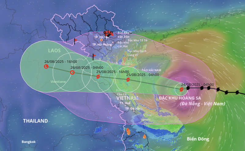
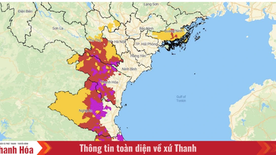
Forecast of the path of storm No. 5. (Source: Vietnam Disaster Monitoring System)
At 7:00 a.m. on August 24, the storm center was at 17.5 degrees North latitude; 111.4 degrees East longitude, in the northwest sea of Hoang Sa archipelago, about 620 km from Nghe An, about 600 km east of Ha Tinh . The strongest wind is level 12 (118-133 km/h), gusting to level 15; moving west, speed about 20 km/h.
Forecast at 7:00 a.m. on August 25, the storm center is at 18.3 degrees North latitude; 107.1 degrees East longitude, in the South of Bac Bo Gulf, about 160km from Nghe An , about 140km from Ha Tinh. Intensity level 12-13, gust level 15, still likely to strengthen. Dangerous area 16.0-20.0 degrees North latitude; 106.5-114.5 degrees East longitude. Affects the Northwestern areas of the East Sea (including Hoang Sa), Bac Bo Gulf, the sea area of South Quang Tri - Hue (including Hon Ngu, Con Co). Natural disaster risk: level 3 at sea, level 4 on the coast of Thanh Hoa - Quang Tri.
At 7:00 a.m. on August 26, the storm moved West-Northwest at 15-20 km/h, entering Upper Laos. The intensity decreased to level 6, gusting to level 8, affecting the Gulf of Tonkin, the sea area of South Quang Tri - Hue (including Hon Ngu, Con Co). Natural disaster risk: level 3 at sea, level 4 along the coast of Thanh Hoa - Quang Tri and the mainland from Thanh Hoa to North Quang Tri.
At 7:00 p.m. on August 26, storm No. 5 continued to weaken into a tropical depression and then a low pressure area over mainland Upper Laos.
Forecasting the impact of storms
At sea:
Northwest East Sea (including Hoang Sa): wind level 8-10, near the storm center level 11-13, gust level 15; waves 5-7m high, near the center 7-9m, rough seas.
Thanh Hoa - Hue (including Hon Ngu, Con Co): wind gradually increases to level 6-8, then to 9-10, near the storm center level 11-13, gusting to level 15; waves 4-6m, near the center 7-9m, rough seas.
Northern Gulf of Tonkin (Cat Hai, Co To, Van Don): wind level 6-7, gust level 9; in the South (Bach Long Vi), wind level 8, gust level 10; waves 2-4m high, rough seas.
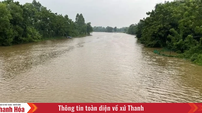
Coastal areas: Coastal areas from Hai Phong to Ha Tinh will see water levels rise 0.5-1.5m.
Estimated water level: Hon Dau 3.3-3.8m, Ba Lat 1.7-2.1m, Sam Son 3.2-3.7m, Hon Ngu 3.2-3.6m, Cua Nhuong 2.2-2.6m.
High risk of flooding in low-lying, coastal and estuary areas on the evening of August 25.
On land:
From the night of August 24, Thanh Hoa - Quang Tri winds will gradually increase to level 7-9, near the storm center level 10-12, gusting to level 14-15. Coastal areas of Quang Ninh - Ninh Binh will have winds of level 6-7, gusting to level 8.
From August 24-26, the Northern Delta, Southern Phu Tho, Thanh Hoa - Hue areas will have heavy rain of 100-150mm, some places over 250mm; Thanh Hoa - Northern Quang Tri 200-400mm, some places over 700mm. Risk of extremely heavy rain (over 200mm/3 hours).
From August 25-26, Hanoi and Da Nang will have moderate to heavy rain; Ho Chi Minh City will have thunderstorms in the evening.
From August 25-27, the upper and central regions of Laos will have 100-250mm of rain, with some places having over 500mm.
The meteorological agency recommends that people and local authorities continuously monitor the storm's developments to proactively respond.
According to Decision 18/2021/QD-TTg, natural disaster risks are classified based on the intensity, scope of influence, areas directly affected and the potential for damage caused by natural disasters. Disaster risk levels are determined for each type of disaster and announced together with the content of disaster forecast and warning bulletins. The risk level of each type of natural disaster is divided into a maximum of 5 levels and is assigned a characteristic color on the maps, according to the increasing level of natural disaster risk, specifically: Level 1 light blue is low risk; Level 2 light yellow is medium risk; Level 3 orange is high risk; Level 4 red is very high risk; Level 5 purple is catastrophic risk. | |
NM
Source: https://baothanhhoa.vn/bao-so-5-ngay-cang-manh-len-canh-bao-do-khu-vuc-thanh-hoa-quang-tri-259221.htm
![[Photo] General Secretary To Lam attends the 80th anniversary of Vietnam's diplomacy](https://vphoto.vietnam.vn/thumb/1200x675/vietnam/resource/IMAGE/2025/8/25/3dc715efdbf74937b6fe8072bac5cb30)


Comment (0)