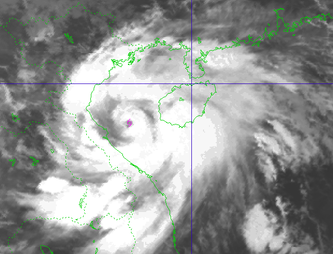
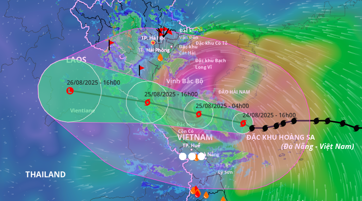
The National Center for Hydro-Meteorological Forecasting said that at 6:00 a.m. on August 25, the center of storm No. 5 was located at about 18.3 degrees north latitude and 107.4 degrees east longitude, about 185 km east southeast of Nghe An, about 165 km east east of Ha Tinh , and about 160 km east northeast of northern Quang Tri.
Near the storm center, the strongest wind is level 14, gusting to level 17 and is moving west-northwest, at a speed of about 15 - 20 km/hour.
Forecast today, August 25, storm No. 5 will enter the provinces from Thanh Hoa to Quang Tri . PHOTO: NCHMF
According to the National Center for Hydro-Meteorological Forecasting, at level 14 intensity, gusting to level 17, storm number 5 is an extremely dangerous storm with extremely large destructive power.
Storms cause extremely strong waves that can sink large ships. Disaster will occur if not prevented.
Due to the influence of storm No. 5, early this morning, at Bach Long Vi station (Hai Phong), strong winds were measured at level 7, gusting to level 9; Co To station (Quang Ninh) strong winds were measured at level 6, gusting to level 9; Bai Chay station (Quang Ninh) strong winds were measured at level 6, gusting to level 8; Hon Ngu station (Nghe An) strong winds were measured at level 7, gusting to level 8; Con Co station (Quang Tri) strong winds were measured at level 6, gusting to level 8.
Today, the western sea area of the northern East Sea has strong winds of level 6 - 7, gusts of level 9, waves 3 - 5 m high, rough seas.
The sea area from Thanh Hoa to Quang Tri (including Hon Ngu island, Con Co special zone) has strong winds of level 7 - 9, then increasing to level 10 - 11, near the storm center, level 12 - 14, gusting to level 17. Waves are 5 - 7 m high, near the storm center, waves are 8 - 10 m high, the sea is very rough.
Forecast of the path of storm No. 5. PHOTO: VIETNAM DISASTER MONITORING SYSTEM
The northern Gulf of Tonkin (including Cat Hai, Co To, and Van Don special zones) has strong winds of level 6-7, gusting to level 9; the southern Gulf of Tonkin (including Bach Long Vi special zone) has strong winds of level 8-9, gusting to level 11. Waves are 3-5 m high, and the sea is very rough.
From the morning of August 25, the mainland from Thanh Hoa to northern Quang Tri has winds gradually increasing to level 8 - 11, gusting to level 12 - 14. Particularly in the southern Thanh Hoa - Ha Tinh area, winds are strong at level 12 - 14, gusting to level 15 - 16; coastal areas of provinces from Quang Ninh to Ninh Binh have winds gradually increasing to level 6 - 8, gusting to level 9 - 10.
Storm No. 5 causes heavy rain up to 700 mm
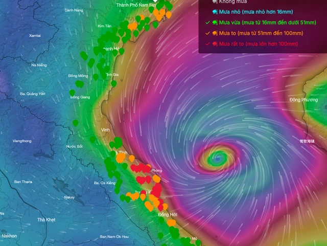
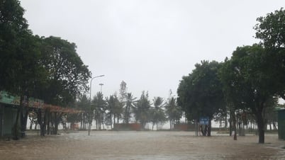
Storm No. 5 is causing heavy rain in the Central provinces. PHOTO: VRAIN
Also according to the National Center for Hydro-Meteorological Forecasting, from today, August 25 to August 26, storm No. 5 will cause widespread heavy rain in the midlands and deltas of the North, Lao Cai province, and provinces from Thanh Hoa to Hue city.
Rainfall is forecast to be 100 - 150 mm, with some places over 250 mm; in particular, the area from Thanh Hoa to northern Quang Tri will have heavy to very heavy rain with rainfall ranging from 200 - 400 mm, with some places over 700 mm.
Due to the influence of storm No. 5, from August 25 to 26, Hanoi will have moderate rain, heavy rain and thunderstorms. On August 25, Da Nang will have rain, moderate rain and thunderstorms. Ho Chi Minh City will have rain, showers and thunderstorms, mainly in the afternoon and evening.
During thunderstorms, people need to be on guard against the risk of tornadoes and strong gusts of wind./.
According to Thanh Nien Newspaper
Source: https://thanhnien.vn/bao-so-5-giat-cap-17-suc-pha-hoai-cuc-ky-lon-185250825065756618.htm
Source: https://baolongan.vn/bao-so-5-giat-cap-17-suc-pha-hoai-cuc-ky-lon-a201301.html






![[Photo] General Secretary To Lam attends the 80th anniversary of Vietnam's diplomacy](https://vphoto.vietnam.vn/thumb/1200x675/vietnam/resource/IMAGE/2025/8/25/3dc715efdbf74937b6fe8072bac5cb30)









Comment (0)