

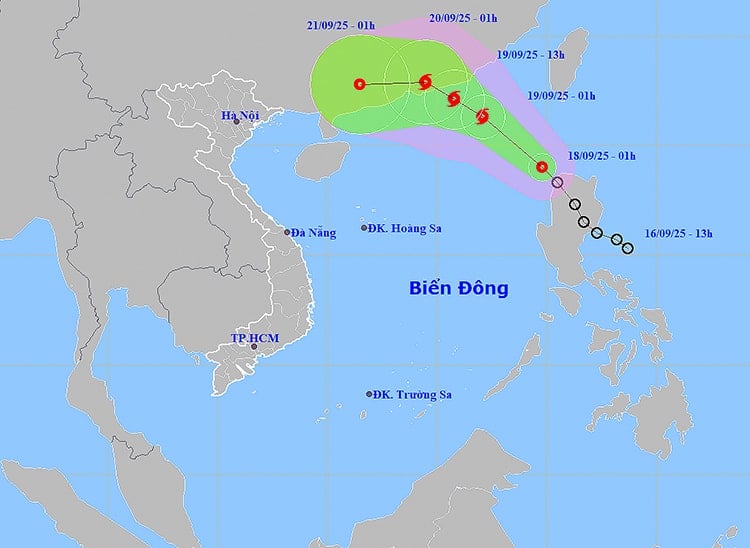
At 1:00 a.m. on September 18, the center of the tropical depression was at about 19.0 degrees North latitude; 119.8 degrees East longitude, in the northeastern sea area of the North East Sea. The strongest wind near the center reached level 7 (50-61 km/h), gusting to level 9. The tropical depression moved northwest at a speed of 15-20 km/h.
In the next 24 hours, the northeastern sea of the North East Sea will have strong winds of level 6-7, gusting to level 9; in the area near the center of the tropical depression, winds of level 8, gusting to level 10, waves 2.5-4.5 m high, rough seas. In the sea area from Khanh Hoa to Ho Chi Minh City, the Central and Southwest East Sea (including the west of Truong Sa sea area), strong southwest winds of level 5, sometimes level 6, gusting to level 7-8, waves 1.5-3 m high.
Notably, on the night of September 19, the northern sea area of the North East Sea had strong winds of level 8-9, gusts of level 10-11, waves 3-5 m high, and very rough seas. The natural disaster risk level was warned at level 2; the northeastern sea area of the North East Sea was at level 3. Experts warned that this is a dangerous area for ships to operate due to strong winds, large waves, and the possibility of tornadoes.
On land, rain increases in many areas. The North has scattered showers and thunderstorms, locally heavy rain, concentrated at night and in the morning. From Thanh Hoa to Quang Tri , there are showers and thunderstorms, with common rainfall of 10-30 mm, locally over 70 mm; risk of heavy rain with high intensity over 70 mm/3 hours.
In the Central and Central Highlands, the rainfall recorded from 7pm on September 17 to 3am on September 18 was very heavy in some places: Nghia Trung (Quang Ngai) 92.6mm, Ia Mo (Gia Lai) 113.2mm, Ia Lop ( Dak Lak ) 80mm. It is forecasted that on September 18, the area from Thua Thien Hue to Lam Dong and the South will continue to have moderate rain, heavy rain, and in some places very heavy rain over 100mm; warning of heavy rain over 80mm/3 hours.
The meteorological agency warned that thunderstorms may produce tornadoes, lightning, hail, and strong gusts of wind. Localized heavy rains may cause flash floods in small rivers and streams, landslides on steep slopes, and flooding in low-lying areas.
Weather forecast for regions across the country:
Hanoi capital is cloudy, with occasional showers and thunderstorms. Light wind. During thunderstorms, there is a possibility of tornadoes, lightning and strong gusts of wind. Lowest temperature 25-27 degrees Celsius. Highest temperature 31-33 degrees Celsius.
The Northwestern provinces are cloudy with scattered showers and thunderstorms. Light winds. There is a possibility of tornadoes, lightning and strong gusts of wind in thunderstorms. The lowest temperature is 23-26 degrees Celsius, in some places below 22 degrees Celsius. The highest temperature is 31-34 degrees Celsius.
The Northeastern region is cloudy with scattered showers and thunderstorms, with some heavy rain in coastal areas. Light wind. There is a possibility of tornadoes, lightning and strong gusts of wind in thunderstorms. The lowest temperature is 23-26 degrees Celsius, in mountainous areas it is below 22 degrees Celsius. The highest temperature is 30-33 degrees Celsius, in some places it is above 33 degrees Celsius.
Provinces from Thanh Hoa to Hue are cloudy with scattered showers and thunderstorms, with some places experiencing heavy to very heavy rain. Light winds. During thunderstorms, there is a possibility of tornadoes, lightning, hail and strong gusts of wind. Lowest temperature 23-26 degrees Celsius. Highest temperature 29-32 degrees Celsius.
The South Central Coast region is cloudy with rain, moderate rain and scattered thunderstorms, locally heavy to very heavy rain. Southwest wind level 2-3. During thunderstorms, there is a possibility of tornadoes, lightning, hail and strong gusts of wind. Lowest temperature 23-26 degrees Celsius. Highest temperature 29-32 degrees Celsius.
The Central Highlands is cloudy with rain, moderate rain and scattered thunderstorms, locally heavy to very heavy rain. Southwest wind level 2-3. During thunderstorms, there is a possibility of tornadoes, lightning, hail and strong gusts of wind. Lowest temperature 20-23 degrees Celsius. Highest temperature 27-30 degrees Celsius, some places above 30 degrees Celsius.
The South is cloudy with rain, moderate rain and scattered thunderstorms, locally heavy to very heavy rain. Southwest wind level 2-3. During thunderstorms, there is a possibility of tornadoes, lightning, hail and strong gusts of wind. Lowest temperature 23-26 degrees Celsius. Highest temperature 29-32 degrees Celsius, some places above 32 degrees Celsius.
Ho Chi Minh City is cloudy with rain, moderate rain and scattered thunderstorms, locally heavy to very heavy rain. Southwest wind level 2-3. During thunderstorms, there is a possibility of tornadoes, lightning, hail and strong gusts of wind. Lowest temperature 24-26 degrees Celsius. Highest temperature 30-33 degrees Celsius.
Source: https://baohaiphong.vn/ap-thap-nhiet-doi-tien-vao-bien-dong-521070.html
![[Photo] Science and Technology Trade Union honors exemplary workers and excellent union officials](https://vphoto.vietnam.vn/thumb/1200x675/vietnam/resource/IMAGE/2025/9/17/842ff35bce69449290ec23b75727934e)
![[Photo] General Secretary To Lam chairs a working session with the Standing Committee of the Government Party Committee](https://vphoto.vietnam.vn/thumb/1200x675/vietnam/resource/IMAGE/2025/9/17/cf3d855fdc974fa9a45e80d380b0eb7c)


Comment (0)