

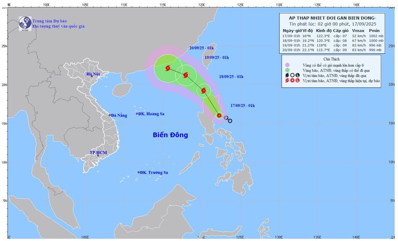
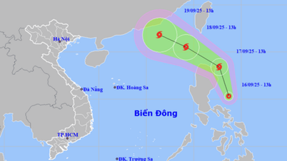
It is forecasted that in the next 24 hours, the tropical depression will likely strengthen. At 1:00 a.m. on September 18, the center of the tropical depression will be at about 19.2 degrees north latitude; 120.3 degrees east longitude, in the sea north of Luzon Island (Philippines), level 8, gusting to level 10 and likely to strengthen into a storm.
According to the National Center for Hydro-Meteorological Forecasting, at 1:00 a.m. on September 17, the center of the tropical depression was located at about 16 degrees north latitude; 122.3 degrees east longitude, in the sea east of Luzon Island (Philippines).
The strongest wind near the center of the tropical depression is level 7 (50-61 km/h), gusting to level 9. The tropical depression moves in a West Northwest direction, at a speed of about 15 km/h.
It is forecasted that in the next 24 hours, the tropical depression will likely strengthen. At 1:00 a.m. on September 18, the center of the tropical depression will be at about 19.2 degrees north latitude; 120.3 degrees east longitude, in the sea north of Luzon Island (Philippines), with a level 8 strength, gusting to level 10 and likely to strengthen into a storm. The risk of natural disasters is at level 3 in the northeastern area of the East Sea.
At 1:00 a.m. on September 19, the storm center may be at about 21.2 degrees north latitude; 118.0 degrees east longitude, in the northeastern sea area of the northern East Sea, with strong winds of level 8-9, gusting to level 11. In the next 48-72 hours, the storm will move west-northwest at a speed of 10-15 km/h, with little change in intensity.
From the night of September 17, the wind in the northeastern part of the East Sea will gradually increase to level 6-7, gusting to level 9. The area near the storm center will have wind level 8, gusting to level 10, waves 2.5-4.5m high, rough seas. There is a high risk for ships operating in the danger zone as they may encounter thunderstorms, tornadoes, strong winds and large waves. During the day and night of September 17, the wind in the central part of the East Sea will be level 5, sometimes level 6, gusting to level 7-8, waves 2-3m high, rough seas.
During the day and night of September 17, the northern, central and southern areas of the East Sea (including the Hoang Sa and Truong Sa seas), the Gulf of Tonkin, the sea area from southern Quang Tri to Ca Mau, from Ca Mau to An Giang and the Gulf of Thailand will have scattered showers and thunderstorms; especially the northeastern sea area of the northern East Sea will have storms.
Thunderstorms pose a risk of tornadoes, strong winds of level 6-7 and waves over 2m high.
On land, last night and early this morning (September 17), the area from Hue to Khanh Hoa had showers and thunderstorms, with some places experiencing heavy rain. The amount of rain measured from 7 p.m. on September 16 to 3 a.m. on September 17 was over 50mm in some places, such as Quang Dien (Hue) 68.2mm, Ia Kenh (Gia Lai) 88.4mm, Song Hinh ( Dak Lak ) 51.8mm.
It is forecasted that in the afternoon and night of September 17, the area from Hue to Lam Dong and the South will continue to have scattered showers and thunderstorms, with common rainfall of 15-30mm, with some places experiencing heavy rain of over 80mm. Rain is likely to appear with high intensity of over 80mm in 3 hours.
Faced with the complex developments of the tropical depression that is likely to strengthen into a storm, the meteorological agency recommends that ships operating at sea closely monitor forecasts, proactively avoid and move away from dangerous areas; local authorities and people in coastal and island areas need to prepare timely response plans.
Source: https://baolamdong.vn/ap-thap-nhiet-doi-sap-manh-len-thanh-bao-bien-dong-manh-391754.html

![[Photo] General Secretary To Lam chairs a working session with the Standing Committee of the Government Party Committee](https://vphoto.vietnam.vn/thumb/1200x675/vietnam/resource/IMAGE/2025/9/17/cf3d855fdc974fa9a45e80d380b0eb7c)
![[Photo] Science and Technology Trade Union honors exemplary workers and excellent union officials](https://vphoto.vietnam.vn/thumb/1200x675/vietnam/resource/IMAGE/2025/9/17/842ff35bce69449290ec23b75727934e)


Comment (0)