
* At 7:00 a.m. on June 10, the center of the tropical depression was located in the central area of the East Sea. The strongest wind near the center reached level 6 (ie from 39 - 49 km/h), gusting to level 8. The tropical depression moved in a West-Northwest direction at a speed of about 10 - 15 km/h.
Forecast for the next 24 - 48 hours, until 7:00 a.m. on June 11, the tropical depression is forecast to continue moving in the West-Northwest direction at a speed of 15 - 20 km/h. The center of the tropical depression is located in the northern area in the middle of the East Sea, with an intensity of level 7, gusting to level 9. Dangerous area at sea: From latitude 13.0N to 18.5N, longitude 112.0E to 118.0E. Natural disaster risk level 3, affecting the northern areas in the middle of the East Sea, including the Hoang Sa area and the East Sea area of the Central region.
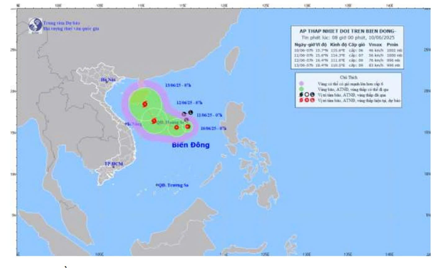 |
| Tropical depression intensity trajectory forecast map issued at 8:00 a.m. June 10, 2025. |
By 7am on June 12, the tropical depression may strengthen to level 8-9, gusting to level 10. The center of the tropical depression is located near the Central coast. The danger zone is from latitude 13.5N to 18.5N, longitude 109.5E to 117.0E. The disaster risk level is level 3, with the area of influence extending to the coastal waters of the Central region and the Southeast region of the Central Central region and the Northern Central Highlands.
The tropical depression is likely to continue to strengthen in the next 48 - 72 hours, moving in a West-Northwest direction at a speed of about 15 - 20 km/h, towards the mainland provinces of the Central Central and Central Highlands. Forecasts show a high possibility of widespread heavy rain, strong winds, thunderstorms and tornadoes in the affected areas.
The North East Sea and the central East Sea have strong winds of level 6 - 7, gusting to level 9. Rough seas, waves from 2 to 4 m high.
The danger zone is warned to have a high risk of thunderstorms, tornadoes, strong winds and large waves. Vessels operating in this area should pay special attention and seek safe shelter.
In Tien Giang province, the weather is cloudy, with showers and thunderstorms in some places during the day, and southwest winds at level 2-3. Although not directly affected, people are advised to closely monitor the next bulletins.
* In response to the developments of the tropical depression, the People's Committee of Tien Giang province issued Document 4372/UBND-KT assigning the Department of Agriculture and Environment to preside over and coordinate with the Provincial Military Command, provincial departments, branches, and sectors, People's Committees of districts, towns, and cities according to their assigned functions and tasks, focusing on the following specific tasks:
Localities, sectors and units closely monitor and update weather developments, hydrometeorology, and disaster warning bulletins from specialized hydrometeorological agencies and scientific agencies under the Ministry of Agriculture and Environment (Department of Hydrometeorology at http://hymetnet.gov.vn/ and http://luquetsatlo.nchmf.gov.vn) to notify captains and owners of vehicles and vessels operating at sea to proactively prevent and ensure safety of people and property; maintain communication to promptly handle bad situations that may occur. At the same time, arrange forces and means to be ready to respond, rescue and salvage when situations arise, ensuring good implementation of the "4 on-site" motto.
Localities, sectors and units must seriously organize on-duty shifts and promptly report incidents to the Department of Agriculture and Environment (via the Department of Irrigation and Forestry, on-duty phone number: 02733.855.108, Email: [email protected]) for timely handling.
CAO THANG
Source: https://baoapbac.vn/xa-hoi/202506/ap-thap-nhiet-doi-dang-di-chuyen-nhanh-tren-bien-dong-1044953/


Comment (0)