


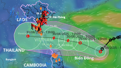
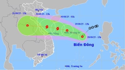
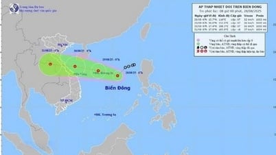
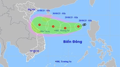
The National Center for Hydro-Meteorological Forecasting said that at 7:00 a.m., the center of the tropical depression was located at 15.7 degrees North latitude - 116 degrees East longitude, in the eastern sea area of the North East Sea. Wind intensity reached level 6-7, gusting to level 9, moving southwest at a speed of about 15km/hour.
The model updated at 8:00 a.m. shows that in the next 24 hours, the tropical depression will tend to strengthen, most likely reaching level 7, gusting to level 9. By 7:00 a.m. on August 29, the center of the tropical depression will be located at about 16.6 degrees North latitude - 112.5 degrees East longitude, right above the Hoang Sa archipelago, the dangerous area extends from 14.5 to 18 degrees North latitude and from 111.5 to 116.5 degrees East longitude.
In the next 48-72 hours, the tropical depression will move mainly in a westerly direction at a speed of about 20km/hour.
The National Center for Hydro-Meteorological Forecasting said that by the morning of August 30, the center of the tropical depression will be at about 17.4 degrees North latitude - 108.3 degrees East longitude, over the sea from Nghe An to Da Nang , maintaining a level 7 intensity, gusting to level 9 before showing signs of weakening when approaching land.

International meteorological agencies such as JTWC (USA) and JMA (Japan) assessed that the tropical depression (area 93W) in the East Sea is still in the organizing stage and has the potential to strengthen, but the level of development is assessed as low to medium.
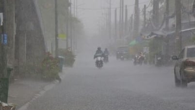
According to meteorological experts, although the possibility of the tropical depression reaching storm level before making landfall has not been confirmed, heavy rain and strong winds in the central provinces from August 29 to 31 is a highly probable scenario.
In the context of the fluctuating atmospheric factors in the Western Pacific and East Sea, the meteorological agency recommends that people on land and fishermen at sea proactively monitor official bulletins to have timely response plans.
Source: https://www.sggp.org.vn/ap-thap-nhiet-doi-co-the-vao-dat-lien-trung-bo-post810517.html
![[Photo] Politburo works with the Standing Committee of Cao Bang Provincial Party Committee and Hue City Party Committee](https://vphoto.vietnam.vn/thumb/1200x675/vietnam/resource/IMAGE/2025/8/28/fee8a847b1ff45188749eb0299c512b2)
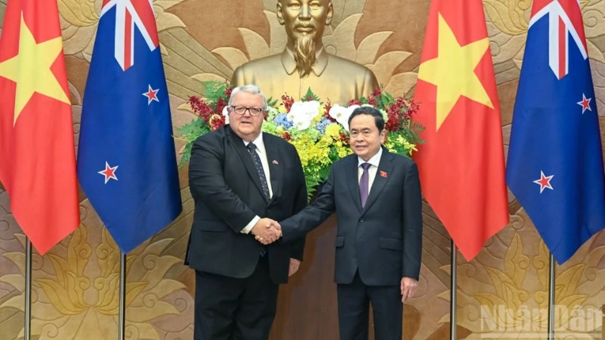
![[Photo] Prime Minister Pham Minh Chinh meets with Speaker of the New Zealand Parliament Gerry Brownlee](https://vphoto.vietnam.vn/thumb/1200x675/vietnam/resource/IMAGE/2025/8/28/cec2630220ec49efbb04030e664995db)
![[Photo] General Secretary To Lam presents the 45-year Party membership badge to comrade Phan Dinh Trac](https://vphoto.vietnam.vn/thumb/1200x675/vietnam/resource/IMAGE/2025/8/28/e2f08c400e504e38ac694bc6142ac331)
![[Photo] General Secretary To Lam attends the opening ceremony of the National Achievements Exhibition](https://vphoto.vietnam.vn/thumb/1200x675/vietnam/resource/IMAGE/2025/8/28/d371751d37634474bb3d91c6f701be7f)
![[Photo] Red flag with yellow star flutters in France on National Day September 2](https://vphoto.vietnam.vn/thumb/1200x675/vietnam/resource/IMAGE/2025/8/28/f6fc12215220488bb859230b86b9cc12)


Comment (0)