
Weather tracking app Windy unexpectedly rose to the top in terms of downloads on the App Store in Vietnam on July 22, and ranked 9th in the list of most downloaded free apps on CH Play.
The spike is believed to be due to the need to monitor the path of Typhoon Wipha.

Windy application leads the list of most downloaded free software on the App Store in Vietnam (Photo: The Anh).
Windy, a free application on both the App Store and CH Play platforms, stands out with its ability to display visual weather conditions based on satellite images.
The app provides detailed information on the storm's track and circulation, and can forecast future storm movements.
Windy's accuracy is highly appreciated thanks to the use of forecast data from prestigious global meteorological and hydrological agencies such as the European Center for Medium-Range Weather Forecasts (ECMWF), the Global Forecast System (GFS) and the US National Oceanic and Atmospheric Administration (NOAA).
By default, Windy's interface displays a wind map. However, users can easily switch to the "Storm Tracker" mode to see detailed forecast information on the movement of Typhoon Wipha at specific time intervals.
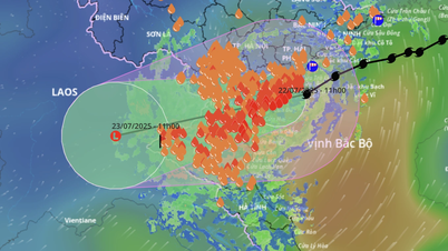
According to the National Center for Hydro-Meteorological Forecasting, at 11:00 a.m. on July 22, the center of storm Wipha made landfall in the mainland areas of Hung Yen - Ninh Binh provinces with the strongest intensity near the center of the storm reaching level 8 (62-74 km/h), gusting to level 10.
Typhoon Wipha continues to move west-southwest at a speed of 10-15km/h. It is forecasted that by 11am on July 23, the storm will weaken into a tropical depression and then continue to weaken into a low pressure area over Upper Laos.
Areas directly affected by the storm include the Gulf of Tonkin, coastal waters and mainland provinces from Quang Ninh to Nghe An .
The Northern Delta and coastal areas, Thanh Hoa and Nghe An are forecast to have moderate to heavy rain, with some places experiencing very heavy rain with rainfall ranging from 70-150mm, and some places over 200mm. Storm surges at Hon Dau ( Hai Phong ) are recorded at 0.6m high and at Ba Lat (Hung Yen) at 0.8m high.
Source: https://dantri.com.vn/cong-nghe/ung-dung-theo-doi-bao-wipha-duoc-tai-nhieu-nhat-tren-iphone-20250722113033689.htm


Comment (0)