
Weather forecast for June 15, storm No. 1 Wutip weakened into a tropical depression, the North and Central regions of our country entered a new heat wave, with the highest temperature in some places above 38°C.
The National Center for Hydro-Meteorological Forecasting said that at 4:00 p.m. on June 14, the center of storm No. 1 Wutip was located in the southwest of Guangdong province (China). The strongest wind near the center of the storm was level 9 (75-88 km/h), gusting to level 11. The storm was moving northeast at a speed of 15-20 km/h.
It is forecasted that by 4:00 p.m. on June 15, storm No. 1 in Guangdong province (China) will move northeast at 15-20km per hour and gradually weaken into a tropical depression.
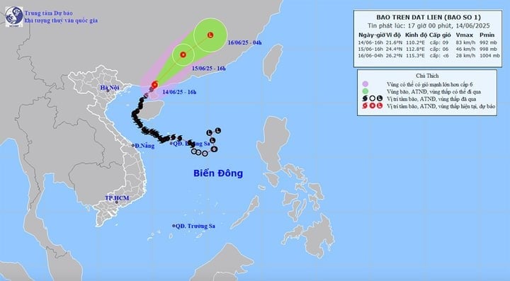
At around 4:00 a.m. on June 16, a tropical depression in Fujian province (China) moved northeast at a speed of 20-25 km/h and gradually weakened into a low pressure area.
Impact of storm No. 1 Wutip after weakening into a tropical depression, the sea area east of the North Gulf of Tonkin has strong winds of level 7-8, gusts of level 10, waves 2-4m high, rough seas. The sea area west of the North Gulf of Tonkin (including Co To and Bach Long Vi island districts) and the northwest of the North East Sea has strong winds of level 5, sometimes level 6, gusts of level 8, waves 2-3m high, rough seas.
Weather highlights for the evening and night of June 14, June 15, 2025
On June 14, the North and Central regions will experience localized heat with temperatures at 1 p.m. in some places above 35°C such as: Yen Chau (Son La) 37°C, Viet Tri (Phu Tho) 36.4°C, Ha Dong ( Hanoi ) 35.5°C, Hoi Xuan (Thanh Hoa) 36°C.
This evening and tonight, June 14, the North will have showers and thunderstorms in some places. On June 15, this area will be hot, with some places experiencing severe heat with the highest temperature commonly ranging from 35-37°C, with some places above 37°C. From June 16, the heat will gradually ease.
From June 15-16, from Thanh Hoa to Phu Yen, temperatures will increase rapidly, heat waves will spread, some places will be extremely hot with the highest temperature ranging from 35-37°C, some places will be over 38°C. Humidity in the air will be low, about 50-55%.
Although it is sunny during the day, in the evening and at night, people living in the Central region need to be on guard against sudden showers and thunderstorms. Although they only occur in a few localized areas, thunderstorms can potentially cause extreme weather phenomena such as tornadoes, lightning, hail and strong gusts of wind.
The heat wave in the Central region is likely to last for many days to come.
In addition, in the next 24 to 48 hours, the Central Highlands and the South will maintain the weather pattern of scattered showers and thunderstorms in some places, scattered showers and thunderstorms in the late afternoon and evening.
Weather forecast for regions across the country in the evening and night of June 14, June 15, 2025
Hanoi No rain at night, hot and sunny during the day, some places are very hot. Light wind. In thunderstorms, there is a possibility of tornadoes, lightning and strong gusts of wind. Lowest temperature 26-28°C. Highest temperature 35-37°C, some places above 37°C.
Northwest In the evening and at night, there will be showers and thunderstorms in some places. During the day, it will be hot and sunny, with some places experiencing severe heat. Light wind. During thunderstorms, there may be tornadoes, lightning, and strong gusts of wind. Lowest temperature 24-27°C, with some places below 23°C. Highest temperature 35-37°C, with some places above 37°C, Lai Chau, Dien Bien 32-35°C.
Northeast In the evening and at night, there will be showers and thunderstorms in some places. During the day, it will be hot and sunny, with some places experiencing severe heat. Light wind. During thunderstorms, there is a risk of tornadoes, lightning, and strong gusts of wind. Lowest temperature 25-28°C, in mountainous areas, some places will be below 24°C. Highest temperature 35-37°C, some places will be above 37°C.
Thanh Hoa to Hue In the evening and at night, there will be showers and thunderstorms in some places. During the day, it will be sunny and hot, with some places experiencing severe heat. Southwest wind level 2-3. During thunderstorms, beware of tornadoes, lightning and strong gusts of wind. Lowest temperature 24-27°C. Highest temperature 35-37°C, with some places above 37°C.
Da Nang to Binh Thuan In the evening and at night, there will be showers and thunderstorms in some places. During the day, it will be sunny and hot in some places. In the North, it will be hot and sunny, and in some places it will be very hot. Southwest wind level 2-3, coastal areas level 3-4. During thunderstorms, tornadoes, lightning and strong gusts of wind are forecast. Lowest temperature 25-28°C. Highest temperature in the North 35-37°C, 32-35°C.
Central Highlands In the late afternoon and evening, scattered showers and thunderstorms, sunny during the day. Southwest wind level 2-3. During thunderstorms, beware of tornadoes, lightning and strong gusts of wind. Lowest temperature 20-23°C. Highest temperature 28-31°C, some places above 31°C.
Southern region: scattered showers and thunderstorms in the late afternoon and evening, sunny during the day. Southwest wind level 2-3. During thunderstorms, there is a possibility of tornadoes, lightning and strong gusts of wind. Lowest temperature 24-27°C. Highest temperature 31-34°C, some places above 34°C.
Source: https://baolangson.vn/thoi-tiet-ngay-15-6-bao-so-1-suy-yeu-thanh-atnd-bac-va-trung-bo-nang-do-lua-5050102.html


Comment (0)