

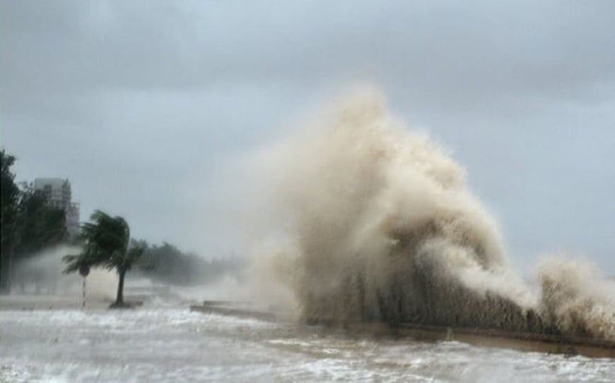
Forecast of impact of storm number 5
At sea: West of the North East Sea, wind level 6-7, gust 9; waves 3-5m; Thanh Hoa - Quang Tri (including Hon Ngu, Con Co) wind level 7-9, increasing to 10-11; near the storm center, wind level 12-14, gust 17; waves 5-7m, near the center 8-10m; North of Bac Bo Gulf, wind level 6-7, gust 9; South (Bach Long Vi) wind level 8-9, gust 11; waves 3-5m.
On land: Thanh Hoa - Northern Quang Tri has strong winds of level 8-11, gusts of 12-14; Southern Thanh Hoa - Ha Tinh has winds of level 12-14, gusts of 15-16; Coastal Quang Ninh - Ninh Binh has winds of level 6-8, gusts of 9-10.
Heavy rain warning: From August 25 to 26: Northern midlands and deltas, Lao Cai, Thanh Hoa - Hue: 100-150mm, locally over 250mm. Thanh Hoa - Northern Quang Tri: 200-400mm, locally over 700mm (some places over 200mm/3 hours); Hanoi has moderate to heavy rain, with thunderstorms; Da Nang has moderate rain, with thunderstorms; Ho Chi Minh City (from August 25 to 26) has showers and thunderstorms in the evening.
Disaster risk warning level: Level 3: North East Sea, Gulf of Tonkin, Thanh Hoa - Quang Tri sea; Level 4: Coastal Thanh Hoa - Quang Tri, mainland Thanh Hoa - North Quang Tri.
Weather forecast for regions across the country today (August 25):
Northwest: Cloudy, scattered showers and thunderstorms at night, locally heavy rain; rain during the day, moderate rain and scattered thunderstorms, locally heavy to very heavy rain. Light wind. Thunderstorms may cause tornadoes, lightning, hail and strong gusts of wind. Temperature 21-30 degrees Celsius.
Northeast: Cloudy, plains, coastal areas have moderate rain, heavy rain and scattered thunderstorms, locally very heavy rain; mountainous and midland areas have scattered showers and thunderstorms, locally very heavy rain, especially in the midland tomorrow there will be moderate rain, heavy rain and scattered thunderstorms, locally very heavy rain. North to Northeast wind level 3-4; especially in coastal areas at night the wind will gradually increase to level 6-8, gusting to level 9. During thunderstorms there is a possibility of tornadoes, lightning, hail and strong gusts of wind. Temperature 22-30 degrees Celsius.
Hanoi: Cloudy, with moderate rain, heavy rain and thunderstorms, locally very heavy rain. North to Northeast wind level 3-4. During thunderstorms, there is a possibility of tornadoes, lightning and strong gusts of wind. Temperature 23-29 degrees Celsius.
Thanh Hoa to Hue: Cloudy, heavy to very heavy rain and thunderstorms; Hue has moderate rain, heavy rain and scattered thunderstorms, locally very heavy rain. Wind gradually increases to level 8-10, near the center Storm level 11-13, gust level 14-15, Hue in particular wind from South to Southeast level 3-4. During thunderstorms there is a possibility of tornadoes, lightning, hail and strong gusts of wind. Temperature 21-39 degrees Celsius.
South Central Coast: Cloudy, scattered showers and thunderstorms, scattered showers and thunderstorms in the afternoon and evening, locally heavy rain in some places; Da Nang has rain, moderate rain and thunderstorms. Southwest wind level 3-4. There is a possibility of tornadoes, lightning, hail and strong gusts of wind during thunderstorms; temperature 23-33 degrees Celsius.
South Central Highlands: Cloudy, scattered showers and thunderstorms, locally heavy rain. Southwest wind level 3. Thunderstorms may cause tornadoes, lightning, hail and strong gusts of wind; temperature 19-28 degrees Celsius.
Southern region: Cloudy, scattered showers and thunderstorms, locally heavy rain. Southwest wind level 3. Thunderstorms may cause tornadoes, lightning, hail and strong gusts of wind; temperature 23-32 degrees Celsius.
Ho Chi Minh City: Cloudy, scattered showers and thunderstorms, locally heavy rain. Southwest wind level 3. Thunderstorms may cause tornadoes, lightning, hail and strong gusts of wind. Temperature 24-31 degrees Celsius.
Source: https://baolangson.vn/thoi-tiet-hom-nay-25-8-bao-so-5-cach-nghe-an-ha-tinh-khoang-200km-5056958.html


![[Photo] General Secretary To Lam attends the 80th anniversary of Vietnam's diplomacy](https://vphoto.vietnam.vn/thumb/1200x675/vietnam/resource/IMAGE/2025/8/25/3dc715efdbf74937b6fe8072bac5cb30)


Comment (0)