

.png)
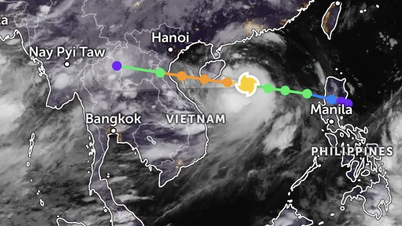
Radar weather images on the afternoon of June 21 show that convective clouds are developing and causing rain in Hai Duong. In addition, thunderstorms in Bac Ninh and Bac Giang provinces are moving towards Hai Duong province.
In the next few hours, this convective cloud area will continue to strengthen and cause showers and thunderstorms for most areas in the province such as: Nam Sach, Ninh Giang, Cam Giang, Hai Duong City, Binh Giang, Gia Loc, Tu Ky, Kinh Mon, Kim Thanh, Chi Linh City.
During thunderstorms, be careful of lightning, tornadoes and strong winds that can break trees, damage houses, traffic works and infrastructure, endangering human life.
Forecast for the next 24 hours (night of June 21 and day of June 22), due to the influence of the compressed low pressure trough with an axis through the North, combined with wind convergence up to 5000m in the North, the forecast is cloudy, with showers and thunderstorms in the evening and at night, sunny during the day, southeast wind level 2. During thunderstorms, be on guard against tornadoes, lightning and strong gusts of wind. The highest temperature during the day is from 32-33 degrees Celsius, the lowest temperature during the day is from 27-28 degrees Celsius.
Source: https://baohaiduong.vn/hai-duong-co-mua-rao-va-giong-set-414594.html


![[Photo] General Secretary To Lam attends the 80th anniversary of Vietnam's diplomacy](https://vphoto.vietnam.vn/thumb/1200x675/vietnam/resource/IMAGE/2025/8/25/3dc715efdbf74937b6fe8072bac5cb30)


Comment (0)