
The National Center for Hydro-Meteorological Forecasting said that on the morning of July 21, storm Wipha (storm number 3) passed the northern area of Leizhou peninsula (China) and entered the northern part of the Gulf of Tonkin.
At 10:00 a.m., the center of the storm was at about 21.2 degrees North latitude, 109.6 degrees East longitude, about 190km from Quang Ninh, 310km East of Hai Phong , about 340km from Hung Yen, and about 360km East Northeast of Ninh Binh.
The strongest wind near the storm center is level 9 (75-88km/h), gusting to level 11. The storm moves in a West-Southwest direction (this is the main direction of the storm in the coming days) at a speed of 10-15km/h.
According to forecast, at around 10:00 p.m. on July 21, the storm center will be in the northern Gulf of Tonkin with a level 10-11 intensity, gusting to level 14.
At 10:00 a.m. on July 22, the storm center was over the Hai Phong - Thanh Hoa sea area with an intensity of level 10-11, gusting to level 14. At around 10:00 a.m. on July 23, the storm weakened into a low pressure area over the mainland of Upper Laos.
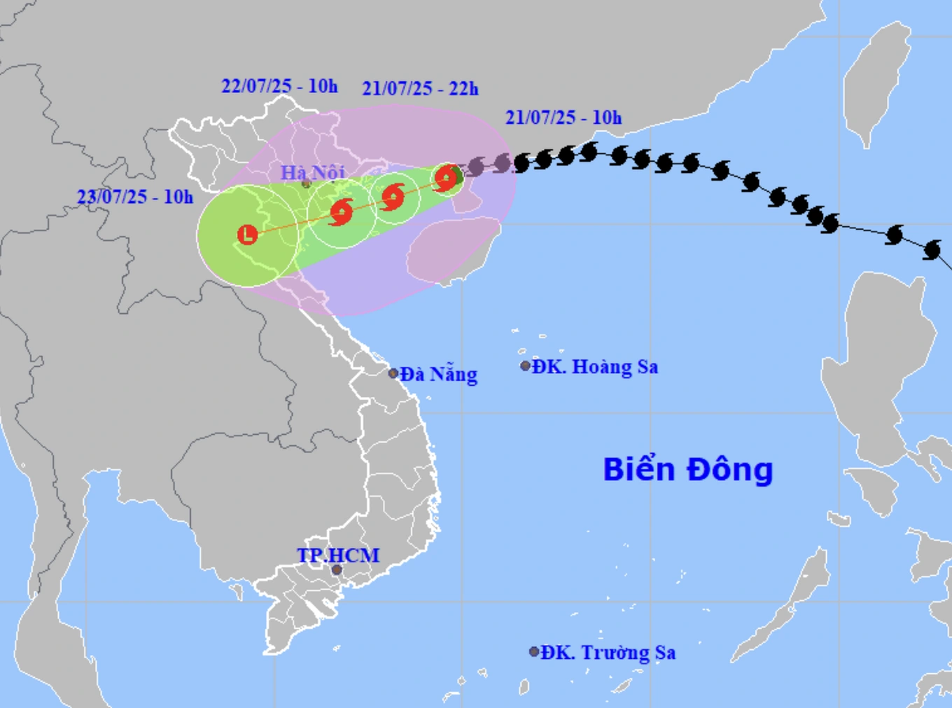
The storm will make landfall in our country on the morning of July 22 (Photo: NCHMF).
Due to the influence of the storm, the Northwestern sea of the North East Sea has winds of level 7-8, gusting to level 10; waves 3-5m high; rough seas.
The northern area of Bac Bo Gulf (Bach Long Vi, Co To, Van Don, Cat Hai, Hon Dau) has winds of level 6-7, then increasing to level 8-9, near the storm center level 10-11, gusting to level 14; waves of 4-6m, rough seas.
In the southern area of Bac Bo Gulf (Hon Ngu), the wind gradually increases to level 6-7, near the storm center level 8-9, gusting to level 11; waves 2-4m high, very rough seas.
Weather forecaster Nguyen Ngoc Huy said that when storm Wipha enters the Gulf of Tonkin, the storm could strengthen to level 10-11, with wind gusts of up to 100km/h.
According to the expert, since this afternoon, coastal areas of Quang Ninh and Hai Phong have had winds of level 6-7, with occasional gusts of level 10 in short periods. By midnight tonight and early tomorrow morning, the cloud rim ahead of the storm will approach the coast of Hai Phong and Nam Dinh with winds of level 9-10, gusts of level 11.
Mr. Huy said that on the morning of July 22, the eye of the storm could approach the mainland of Hung Yen - Ninh Binh area. The area directly affected by strong winds of level 10-11 includes the provinces of Quang Ninh, Hai Phong, Hung Yen, Ninh Binh, then Thanh Hoa and Nghe An.
In addition, the area affected by strong winds of level 8-9, sometimes gusting to level 10, includes Hanoi, Bac Giang, and Hoa Binh.
The expert warned of very heavy rain caused by the storm circulation in the provinces of Quang Ninh, Hai Phong, Ninh Binh, Hung Yen, Thanh Hoa, Nghe An, and Son La.
Rainfall is generally 300-350mm, with some places reaching 500-600mm. It is necessary to guard against the risk of flooding in urban areas, riverside areas and flash floods in the midlands and mountainous areas of Thanh Hoa and Nghe An provinces.
Dantri.com.vn
Source: https://dantri.com.vn/xa-hoi/bao-wipha-da-vao-vinh-bac-bo-kha-nang-tang-2-cap-trong-hom-nay-20250721112540991.htm


![[Photo] National Assembly Chairman Tran Thanh Man visits Vietnamese Heroic Mother Ta Thi Tran](https://vphoto.vietnam.vn/thumb/1200x675/vietnam/resource/IMAGE/2025/7/20/765c0bd057dd44ad83ab89fe0255b783)


Comment (0)