

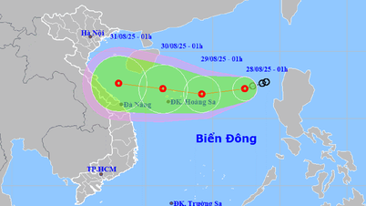
According to the National Center for Hydro-Meteorological Forecasting, at 10:00 a.m. on August 27, the center of the tropical depression was at about 17.7 degrees North latitude; 119.0 degrees East longitude. The strongest wind near the center of the tropical depression was level 6 (39 - 49 km/h), gusting to level 8. Moving in the West Southwest direction at a speed of 10 - 15 km/h.
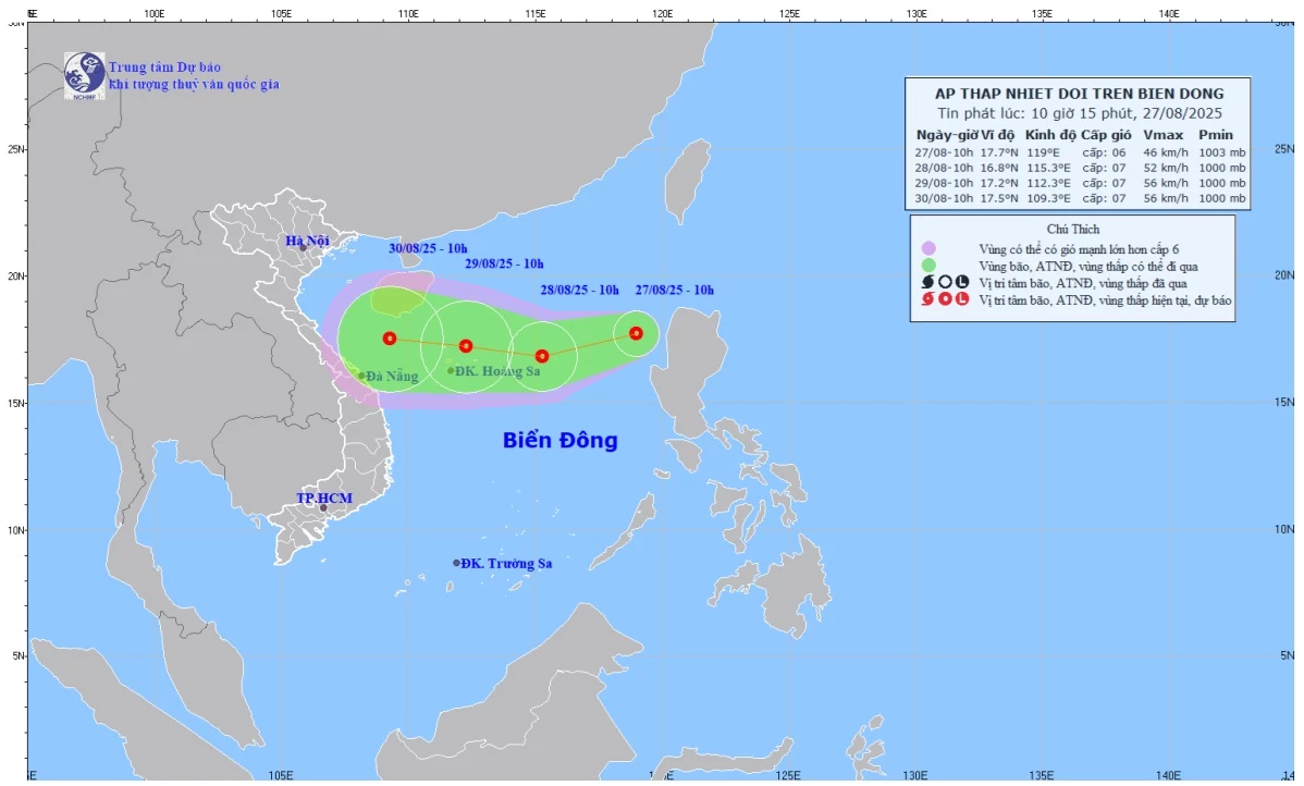 |
| Forecast map of tropical depression trajectory and intensity at 10:15 a.m. on August 27, 2025. |
The Hydrometeorological Agency forecasts that at 10:00 a.m. on August 28, the center of the tropical depression will be at about 16.8 degrees North latitude; 115.3 degrees East longitude, about 410 km east of Hoang Sa special zone. The strongest wind near the center of the tropical depression is at level 6 - 7, gusting to level 9. Moving in the West Southwest direction at a speed of 15 - 20 km/h and is likely to strengthen further.
Forecast by 10:00 on August 29, the center of the tropical depression is at about 17.2 degrees North latitude; 112.3 degrees East longitude, in the Hoang Sa special zone sea area. The strongest wind near the center of the tropical depression is level 7, gusting to level 9. Moving west at a speed of 15km/hour.
From the next 48 to 72 hours, the tropical depression will continue to move mainly in the West direction, traveling 10 - 15km per hour.
Due to the influence of the tropical depression, the eastern sea area of the North East Sea has strong winds of level 6 - 7, gusting to level 9; waves 2 - 4m high, rough seas.
The meteorological agency warns that ships operating in the above-mentioned dangerous areas are likely to be affected by storms, whirlwinds, strong winds, and large waves.
According to VNA/Tin Tuc and Dan Toc Newspaper
Source: https://baoquangtri.vn/xa-hoi/202508/bao-so-5-vua-tan-bien-dong-don-ap-thap-nhiet-doi-moi-6ca3b99/


![[Photo] Images of the State-level preliminary rehearsal of the military parade at Ba Dinh Square](https://vphoto.vietnam.vn/thumb/1200x675/vietnam/resource/IMAGE/2025/8/27/807e4479c81f408ca16b916ba381b667)
![[Photo] Parade blocks pass through Hang Khay-Trang Tien during the preliminary rehearsal](https://vphoto.vietnam.vn/thumb/1200x675/vietnam/resource/IMAGE/2025/8/27/456962fff72d40269327ac1d01426969)


Comment (0)