
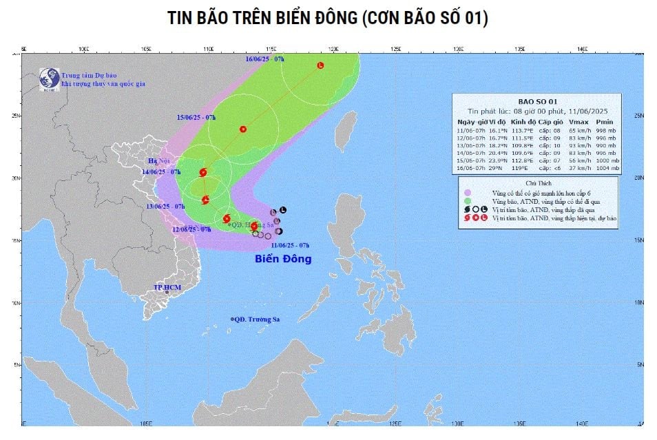
At 7:00 a.m., the center of the storm was located at about 16.1 degrees North latitude; 113.7 degrees East longitude in the sea east of Hoang Sa area. The strongest wind near the center of the storm was level 8 (62-74 km/h), gusting to level 10. The storm moved slowly in the West Northwest direction at a speed of about 5-10 km/h.
At 7:00 a.m. on June 12, the storm moved west-northwest over the Hoang Sa area at a speed of about 10 km/h and was likely to strengthen. The storm's strongest wind was level 9, gusting to level 11. The dangerous area was identified as the northern East Sea (including the Hoang Sa area). Disaster risk level 3.
 |
The tropical depression has strengthened into a storm - storm number 1 in 2025. |
At 7:00 a.m. on June 13, the storm moved northwestward in the southern area of Hainan Island (China) at a speed of about 5-10 km/h and was likely to strengthen. The storm's strongest wind was level 10, gusting to level 13. The dangerous area was identified as the northern East Sea (including the Hoang Sa area), the sea area east of the Gulf of Tonkin and the offshore area from Quang Tri to Quang Ngai . The natural disaster risk level was level 3.
At 7:00 a.m. on June 14, the storm moved northward over the waters west of Leizhou Peninsula (China) at a speed of about 5-10 km/h and gradually weakened. The storm's strongest wind was level 9, gusting to level 12. The dangerous area was identified as the waters west of the North East Sea (including the Hoang Sa area), and the waters east of the Gulf of Tonkin.
Warning, from the next 72 to 120 hours, the storm will move in the North Northeast direction then change to the Northeast direction at about 20km per hour.
Due to the influence of the storm, the North East Sea area (including the sea area of Hoang Sa), the North of the central East Sea area has thunderstorms and strong winds of level 6-7, the area near the storm's center has winds of level 8-9, gusts of level 11, waves 3-5m high, very rough seas. The South of the central East Sea area, the South East Sea area (including the sea area of Truong Sa) has strong southwest winds of level 6, sometimes level 7, gusts of level 8-9, waves 2-4m high, rough seas.
Ships operating in the above mentioned dangerous areas are likely to be affected by storms, whirlwinds, strong winds and large waves.
NGOC ANH
* Please visit the Society section to see related news and articles.
Source: https://baodaknong.vn/ap-thap-nhiet-doi-da-manh-len-thanh-bao-bao-so-1-nam-2025-255222.html


![[Photo] Prime Minister Pham Minh Chinh receives leaders of several Swedish corporations](https://vphoto.vietnam.vn/thumb/1200x675/vietnam/resource/IMAGE/2025/6/14/4437981cf1264434a949b4772f9432b6)


Comment (0)