At 4:00 a.m. this morning, the center of the tropical depression was at about 15.7 degrees North latitude - 115.7 degrees East longitude, about 360 km East Southeast of the Paracel Islands. The strongest wind in the center of the tropical depression reached level 6 (from 39-49 km/h), gusting to level 8. This cyclone system is moving slowly in a westerly direction, at a speed of about 5 km/h.
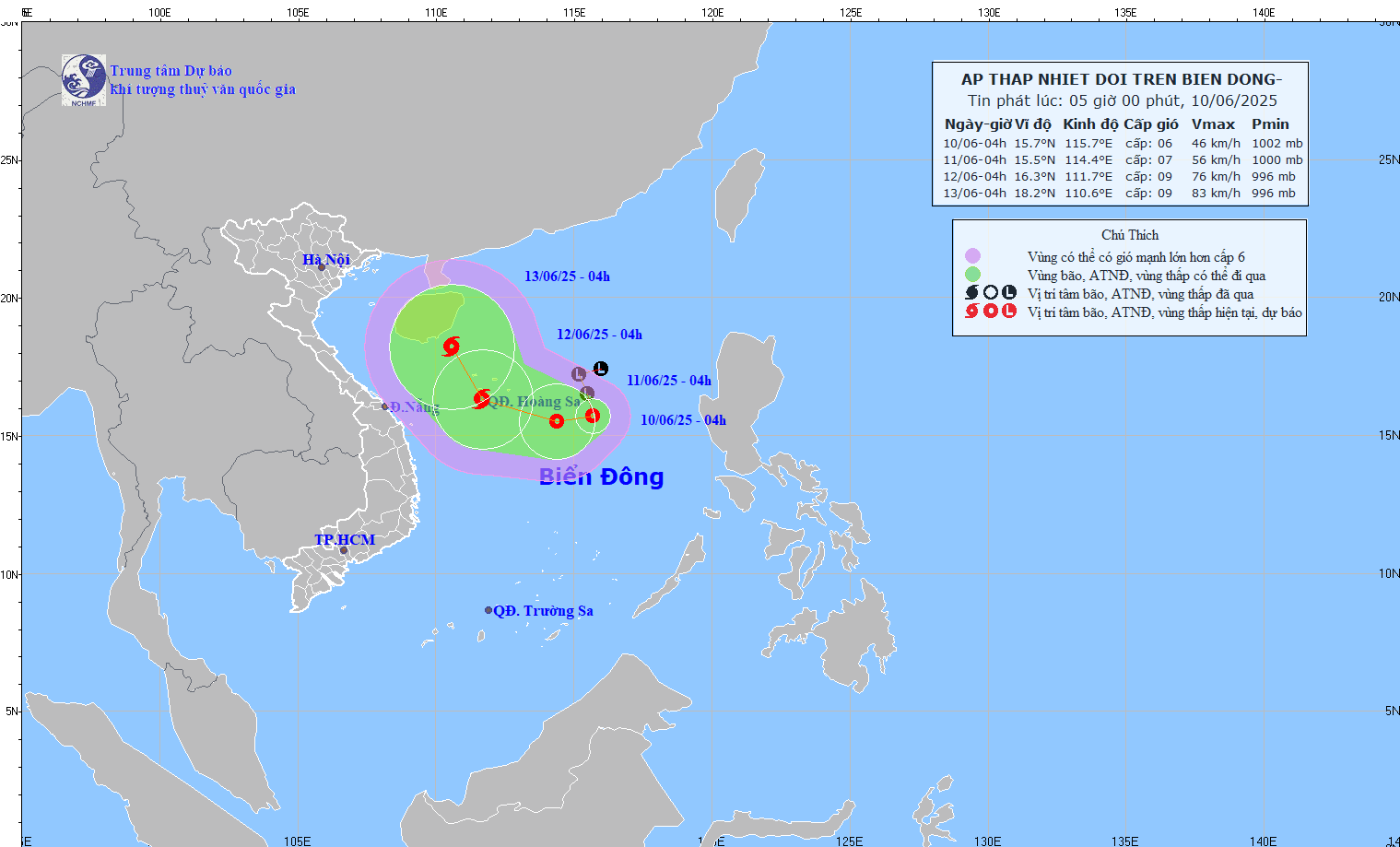
It is forecasted that in the next 24 hours, the tropical depression will continue to move westward, moving about 5km per hour and is likely to strengthen. By early morning on June 11, the center of the tropical depression will be at about 15.5 degrees North latitude - 114.4 degrees East longitude, about 240km East Southeast of Hoang Sa archipelago. Strong winds of level 6-7, gusting to level 9.
The dangerous area in the East Sea in the next 24 hours (strong winds from level 6, gusts from level 8 or higher) is between 13 and 18.5 degrees North latitude and 112 and 118 degrees East longitude. The level of natural disaster risk due to strong winds at sea is at level 3, directly affecting the North East Sea area (including Hoang Sa archipelago) and the northern sea area in the middle of the East Sea.
In the next 24 to 48 hours, the tropical depression is likely to strengthen into a storm, moving in a West-Northwest direction at a speed of 10-15 km/h. By early morning on June 12, the storm center will be located over the Hoang Sa archipelago, at about 16.3 degrees North latitude - 111.7 degrees East longitude. Strong winds of level 8-9, gusting to level 11.
The danger zone in the next 48 hours will expand from 13.5 to 18.5 degrees North latitude and from 109.5 to 117.0 degrees East longitude. The disaster risk level continues to remain at level 3, affecting the North East Sea, the northern sea area between the East Sea and the offshore waters from Thua Thien Hue to Quang Ngai .
In the next 48 to 72 hours, the storm is likely to change direction, moving to the North Northwest at a speed of about 10 km/hour and continue to strengthen.
At sea, the North East Sea and the North Central East Sea will have thunderstorms with strong winds of level 6-7, gusting to level 9; rough seas, waves 2-4m high. Ships operating in the danger zone should pay special attention to the risk of thunderstorms, tornadoes, gusts and big waves.
According to the Japan Meteorological Agency (JMA), the tropical depression is currently under the influence of a stable tropical zone and is likely to gradually strengthen into a storm with the international name "Taifu" in the next 72 hours. The sea weather forecast around the Paracel Islands is expected to have strong gusts of wind, accompanied by heavy showers and thunderstorms.
The US Navy's Typhoon Forecast Service assesses that the tropical depression will move west and west-northwest, passing through the northern South China Sea with increasing wind gusts. Current models indicate that conditions for rainfall and increased wind speed will become more favorable in the next 48-72 hours.
Source: https://www.sggp.org.vn/ap-thap-nhiet-doi-da-manh-len-co-the-thanh-bao-tren-bien-dong-post798820.html








![[Photo] National Assembly Chairman Tran Thanh Man attends the State Audit Congress](https://vphoto.vietnam.vn/thumb/1200x675/vietnam/resource/IMAGE/2025/6/10/5813d32d61614c44a04f114ec3ecf35d)













Comment (0)