

Speaking to the press at noon on August 25, Mr. Mai Van Khiem, Director of the National Center for Hydro-Meteorological Forecasting, said that storm No. 5 will cause extremely heavy rain, high waves, and strong winds; at the same time, he emphasized that localities must not be subjective about the risk of flash floods and landslides in the next 2-3 days.
 |
| Mr. Mai Van Khiem, Director of the National Center for Hydro-Meteorological Forecasting, informed about storm No. 5 at noon on August 25. |
Reporter: Sir, what specific impacts has storm number 5 caused this morning?
Mr. Mai Van Khiem: Up to this point, coastal monitoring stations have only recorded initial strong winds, not yet at their peak because the storm is still more than 100 km from shore.
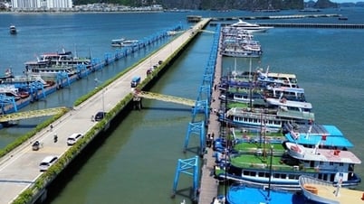
Specifically, in Nghe An and Ha Tinh , the wind is level 6, gusting to level 8-9; Hon Ngu island in particular has wind level 8, gusting to level 9. Northern sea areas such as Hai Phong and Quang Ninh have wind level 5-6; Co To island has wind level 7, gusting to level 9; Bai Chay has wind level 6, gusting to level 8.
The waves were very high this morning: Nghi Xuan radar (Ha Tinh) measured 6.9-8.35 m; in Nghe An 5.25 m. Other areas also recorded high waves.
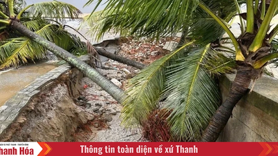
It is forecasted that in the coming hours, from southern Quang Tri to Thanh Hoa, waves of 5-7m may appear, and over 8m near the storm center. This is a very big risk to the dike system, especially in northern Nghe An, Thanh Hoa, Nam Dinh, Thai Binh - places with weak dike lines that need to be extremely cautious.
Reporter : Regarding rainfall, what is the current situation, sir?
Mr. Mai Van Khiem: From yesterday evening (August 24) to this morning, most of the North and North Central regions had moderate to heavy rain, especially the North Central region had very heavy rain. Ha Tinh had over 300mm in many places, of which Cam Xuyen recorded 176.2mm in just 3 hours (7am to 10am). This is a very large level.
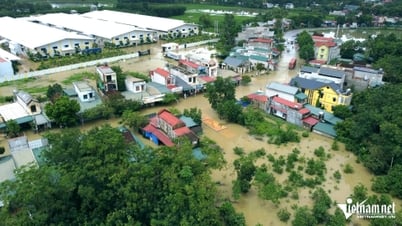
Heavy rain is currently concentrated in Ha Tinh, Quang Tri, Nghe An and will continue today and tomorrow when the storm circulation directly impacts. The risk of major flooding on river systems, flooding of low-lying areas and urban areas is very high. Nghe An, Ha Tinh, Thanh Hoa, Quang Tri provinces, especially the western mountainous areas - are at risk of flash floods and serious landslides.
Reporter: So what about the intensity and direction of the storm?
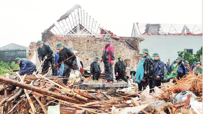
Mr. Mai Van Khiem : At 10 am, the storm was at level 13-14, gusting to level 16, about 120 km from Nghe An and 100 km from Ha Tinh, moving west-northwest at a speed of 10 km/h-15 km/h, slower than in the morning. Analysis of satellite and radar cloud images shows signs of decreasing intensity, possibly decreasing from level 14 to level 13 in the next 1-2 hours. This is a positive thing, because if it remains at level 13-14 when it reaches the shore, many structures and houses will be severely affected.
It is expected that from 3-6 pm this afternoon, the storm will enter the northern Ha Tinh-Nghe An area. The strongest wind around the storm center (radius of about 50km) can reach over level 12, gusting to level 14-15. Localities such as Vinh city, Cua Lo, Cua Hoi, Nghi Xuan district and southern Thanh Hoa need to pay special attention.
Reporter: Can you warn more about the risks after the storm?
Mr. Mai Van Khiem: The biggest risk is still flash floods and landslides. From 7pm yesterday until now, although the storm has not made landfall, the rainfall has been very heavy. We note: even when the storm weakens and the final bulletin is issued, it does not mean the risk is over. Flash floods and landslides will continue for the next 2-3 days.
In addition, the rain will not only be concentrated in coastal areas but also spread to Phu Tho, Hoa Binh, Son La, and Lao Cai. After making landfall, the storm will move to Central and Upper Laos, bringing large amounts of moisture, causing additional rain in the upper reaches of rivers originating from Laos, such as the Ca River. This could cause flooding in the upper reaches, affecting the lower reaches of our country.
Reporter: With the slow moving speed of the storm, will the impact last longer?
Mr. Mai Van Khiem: That's right. When moving slowly, the storm's impact can last 6-10 hours. This is a point that needs special attention. When the storm weakens, the meteorological agency will issue a final bulletin to announce that the strong winds will temporarily stop, and activities can gradually return to normal. However, with regard to flash floods and landslides, we recommend that we continue to monitor closely for many days afterward.
According to THANH TRA/ nhandan.vn
Source: https://baovinhlong.com.vn/thoi-su/202508/nguy-co-lu-quet-sat-lo-dat-keo-dai-nhieu-ngay-sau-bao-so-5-d3c266e/
![[Photo] Brilliant red of the exhibition 95 years of the Party Flag lighting the way before the opening](https://vphoto.vietnam.vn/thumb/1200x675/vietnam/resource/IMAGE/2025/8/27/e19d957d17f649648ca14ce6cc4d8dd4)


![[Photo] Prime Minister Pham Minh Chinh receives CEO of Samsung Electronics](https://vphoto.vietnam.vn/thumb/1200x675/vietnam/resource/IMAGE/2025/8/26/373f5db99f704e6eb1321c787485c3c2)
![[Photo] Prime Minister Pham Minh Chinh chairs meeting of National Steering Committee on International Integration](https://vphoto.vietnam.vn/thumb/1200x675/vietnam/resource/IMAGE/2025/8/26/9d34a506f9fb42ac90a48179fc89abb3)


Comment (0)