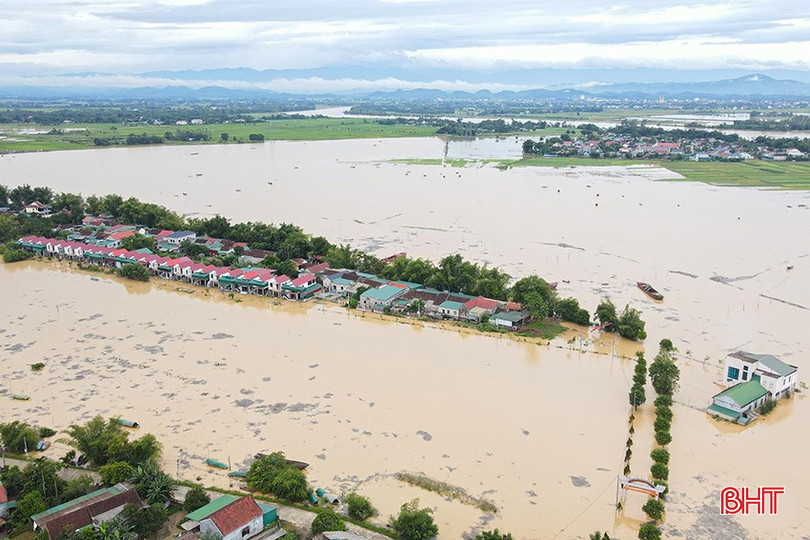
The Ministry of Agriculture and Environment (MARD) has just completed and submitted to the Government the Project "Prevention of landslides and flash floods in the Central and Northern mountainous regions", in order to respond to the increasingly serious natural disasters caused by climate change.
The project aims to proactively prevent, combat, respond effectively, and minimize human and property damage caused by landslides and flash floods, contributing to ensuring stable life and sustainable socio -economic development, ensuring security, national defense, and climate change adaptation in provinces and cities in the Central and Northern mountainous regions.
The specific goal is that by 2030, 100% of the provinces within the scope of the project will complete: risk zoning maps, landslide and flash flood risk zoning maps at a scale of 1:50,000 (for the whole province), a scale of 1:10,000 and larger (for areas/communes/points at high and very high risk) to serve prevention, response and planning, and socio-economic development;
By 2035, the monitoring, forecasting, warning and communication system for landslides and flash floods will be invested and modernized; the automation rate across the entire network of stations will reach over 95% for meteorological and rain gauge stations; areas at high risk of flash floods and landslides will be promptly warned and instructed on response skills when landslides and flash floods occur; 100% of administrative agencies at all levels, organizations and households in areas regularly affected by landslides and flash floods will receive full information, documents and knowledge of landslide and flash flood prevention skills;
By the end of 2026, 100% of high-risk areas that do not have conditions to arrange for evacuation will have emergency evacuation plans to a safe place when detecting the risk of landslides or flash floods; 100% of locations and areas with high risk of landslides or flash floods will have warning signs posted.
The project also aims to apply new, advanced technologies such as artificial intelligence, big data, remote sensing, geographic information systems, and drones in the prevention and control of natural disasters such as landslides and flash floods.
The scope of the project implementation is the provinces and cities in the Central and Northern mountainous regions including Dien Bien, Lai Chau, Son La, Lao Cai, Lang Son, Cao Bang, Tuyen Quang, Quang Ninh, Bac Ninh , Thai Nguyen, Phu Tho, Thanh Hoa, Nghe An, Ha Tinh, Quang Tri, Hue, Da Nang, Quang Ngai, Khanh Hoa, Lam Dong, Gia Lai, Dak Lak.
The total budget for implementing the project is expected to be 161,000 billion VND, allocated from the following sources: State budget (including central budget and local budget) according to the provisions of the State Budget Law and the provisions of the law on public investment; Central and local Disaster Prevention and Control Fund; integrated capital from programs, plans, projects, socialized capital and other legal capital sources according to the provisions of law.
The submission of this project is an important step towards realizing Resolution 01/NQ-CP in 2025 on modernizing the hydrometeorological system and enhancing the capacity to respond to climate change - one of the biggest challenges today.
According to the Ministry of Agriculture and Environment, landslides and flash floods are becoming increasingly serious due to climate change, especially in 2020, 2023, 2024, and 2025, causing great damage to people and property. Although there are many policies, there is still a lack of legal basis, data, warnings, and investment capital.
Source: https://baohatinh.vn/ha-tinh-du-kien-la-122-tinh-thanh-thuoc-de-an-phong-chong-sat-lo-lu-quet-post293183.html




![[Photo] Nghe An: Provincial Road 543D seriously eroded due to floods](https://vphoto.vietnam.vn/thumb/1200x675/vietnam/resource/IMAGE/2025/8/5/5759d3837c26428799f6d929fa274493)




![[Photo] Discover the "wonder" under the sea of Gia Lai](https://vphoto.vietnam.vn/thumb/1200x675/vietnam/resource/IMAGE/2025/8/6/befd4a58bb1245419e86ebe353525f97)











Comment (0)