

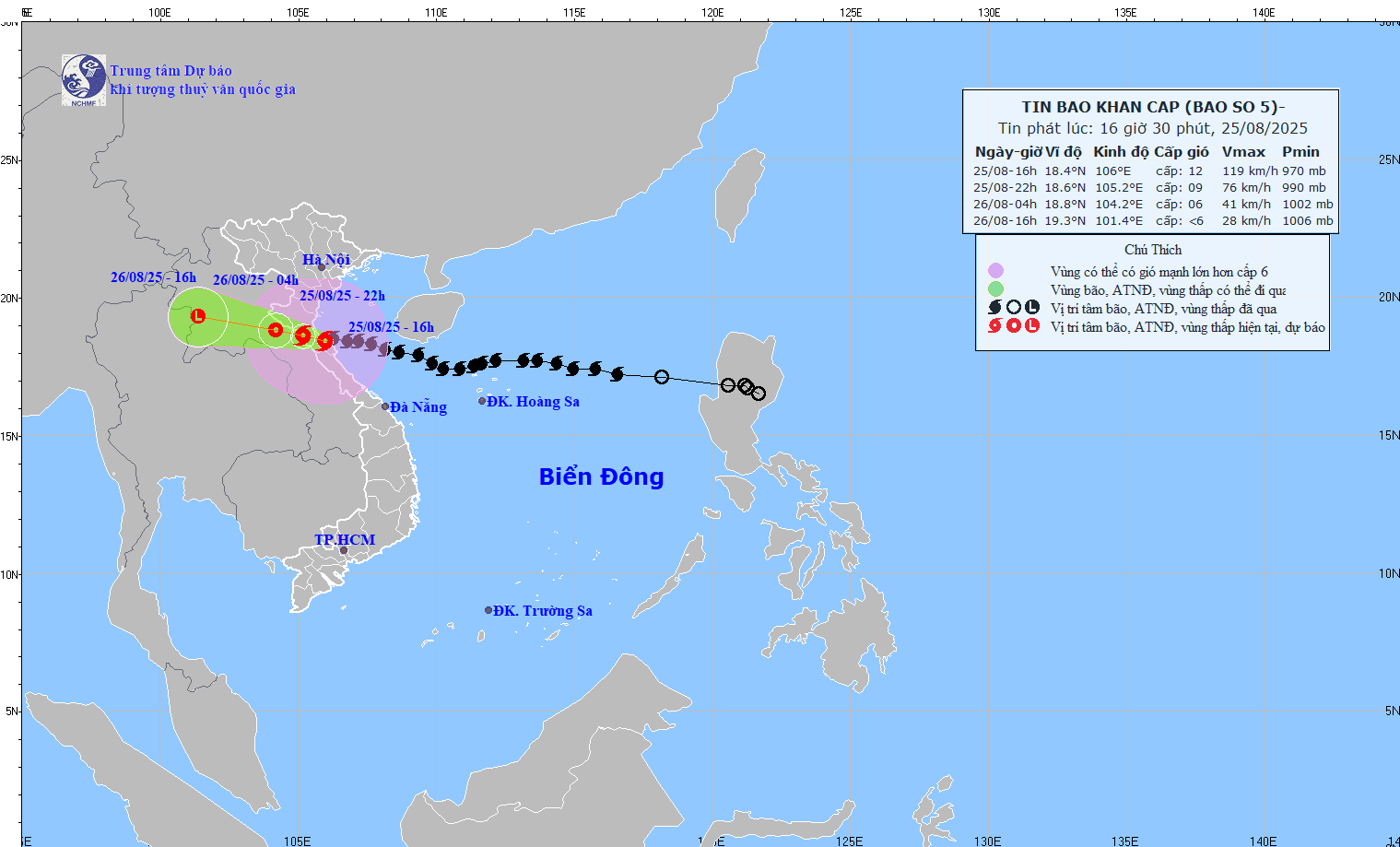
Storm status
In the past 3 hours, storm No. 5 has barely moved, its intensity has decreased to level 12, gusting to level 14. It is forecasted that in the next 3-6 hours, storm No. 5 will move in a West-Northwest direction, making landfall in the North Ha Tinh - South Nghe An area. The risk of strong winds from storm No. 5 is still present.
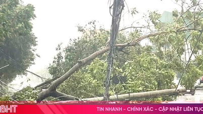
Due to the impact of the storm, many places recorded strong winds: at Bach Long Vi level 7, gusting to level 9; Co To level 7, gusting to level 10; Bai Chay level 6, gusting to level 8; Van Ly (Ninh Binh) level 8, gusting to level 9; Dien Chau ( Nghe An ) level 9, gusting to level 11; Quynh Luu level 7, gusting to level 10; Hon Ngu level 8, gusting to level 11; Hoanh Son (Ha Tinh) level 7, gusting to level 9; Ky Anh level 8, gusting to level 11; Cam Nhuong level 9, gusting to level 12; Con Co (Quang Tri) level 6, gusting to level 8.
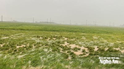
Storm surge was measured at Sam Son at 1.01m, Hon Ngu at 1.66m, and Vung Ang at 0.51m. Provinces from the Northern Delta to Thanh Hoa - Quang Tri had moderate to heavy rain, with some places experiencing very heavy rain of over 500mm.
At 4:00 p.m. on August 25, the storm's center was at approximately 18.4°N; 106.0°E, in the coastal waters of Nghe An - Ha Tinh. The strongest winds were level 11-12 (103-133 km/h), gusting to level 14, moving west-northwest at a speed of 15-20 km/h.
Storm forecast (next 6 - 24 hours)
By 10:00 p.m. on August 25, the storm was moving West-Northwest at a speed of 15-20 km/h, with the center of the storm at about 18.6°N - 105.1°E, on the mainland of Thanh Hoa - Ha Tinh provinces. The intensity decreased to level 8-9, gusting to level 11. The dangerous area is from latitude 17.0°N to 20.5°N, west of longitude 109.0°E. Disaster risk level: level 3, affecting the North of Bac Bo Gulf (including Bach Long Vi special zone), the sea area from Thanh Hoa to Quang Tri (including Hon Ngu island).
At 4:00 a.m. on August 26, the storm continued to move West-Northwest at 15-20 km/h, with its center at about 19.0°N - 104.1°E, in Central Laos. Its intensity remained at level 6, with gusts at level 8. The danger zone remained from latitude 17.0°N to 20.5°N, west of longitude 108.5°E. Level 3 disaster risk still applied to the northern Gulf of Tonkin and the sea area from Thanh Hoa to Quang Tri.
At 4:00 p.m. on August 26, the storm moved West-Northwest at about 20 km/h, gradually weakening into a low pressure area at about 19.4°N - 101.4°E, in the Central Laos region.
Forecasting the impact of storms
At sea: The sea area from Thanh Hoa to Quang Tri (including Hon Ngu island, Con Co special zone) has strong winds of level 8-10, near the storm center level 11-12, gusting to level 14; waves 4.0-6.0m high, near the storm center 7.0-9.0m, rough seas. Northern Bac Bo Gulf (including Cat Hai, Co To, Van Don) has winds of level 6-7, gusting to level 9; especially in the southern area of the Northern Bac Bo Gulf (including Bach Long Vi) winds of level 7-8, gusting to level 10; waves 3.0-5.0m high, rough seas.
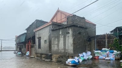
Rising water: At the coast and islands from Hai Phong - Nghe An, the water level continues to rise due to tides combined with storms, increasing by 0.5-1.0m. At Hon Dau (Hai Phong), it reaches 3.4-3.9m; Ba Lat (Ninh Binh) 1.7-2.2m; Sam Son (Thanh Hoa) 3.7-4.2m; Hon Ngu (Nghe An) 3.8-4.0m. There is a high risk of flooding dikes, coastal roads and river mouths, especially in Nghe An and Thanh Hoa on the evening of August 25.
Warning: Weather conditions at sea and along the coast are extremely dangerous. Facilities such as boats, aquaculture areas, dykes, and coastal roads are at risk of damage, capsizing, and flooding due to strong winds, large waves, and rising sea levels.
On land: North Thanh Hoa wind level 7-8, gust 9-10; South Thanh Hoa - North Ha Tinh wind level 9-10, near the storm center level 11-12, gust 13-14; South Ha Tinh - Quang Tri and coastal areas from Quang Ninh to Ninh Binh wind level 6-8, gust 9-10.
Heavy rain: From the evening of August 25 to the end of August 26, the midlands and deltas of the North, Lao Cai, Son La and the provinces from Thanh Hoa to Quang Tri will have heavy to very heavy rain, generally 70-150mm, some places over 250mm; Thanh Hoa to Northern Quang Tri will have rain of 150-350mm, some places over 500mm. Warning of the risk of extremely heavy rain over 200mm/3 hours. In Hanoi, there will be moderate to heavy rain, with thunderstorms; Da Nang will have showers at times; Ho Chi Minh City will have rain, thunderstorms concentrated in the evening. From August 25 to 27, Upper and Central Laos will have heavy rain of 100-250mm, some places over 500mm.
Source: https://baonghean.vn/du-bao-trong-3-6-gio-toi-bao-so-5-se-di-vao-dat-lien-khu-vuc-bac-ha-tinh-nam-nghe-an-10305200.html

![[Photo] General Secretary To Lam attends the 80th anniversary of Vietnam's diplomacy](https://vphoto.vietnam.vn/thumb/1200x675/vietnam/resource/IMAGE/2025/8/25/3dc715efdbf74937b6fe8072bac5cb30)


Comment (0)