


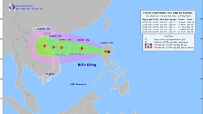
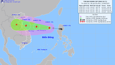
Path of ATND on the morning of August 22
This morning (August 22), a low pressure area in the eastern part of Luzong Island (Philippines) has strengthened into a tropical depression. At 10:00 a.m. on August 22, the center of the tropical depression was at about 16.7 degrees North latitude; 121.3 degrees East longitude, on the mainland of Luzong Island (Philippines). The strongest wind near the center of the tropical depression is level 6-7 (39-61 km/h), gusting to level 9; moving northwest at a speed of 10-15 km/h.
Around tonight (August 22), the tropical depression will move into the East Sea, likely to strengthen into a storm, the 11th storm in the Northwest Pacific region and the 5th storm in the East Sea (international name is Kajiki).
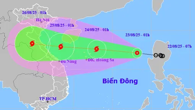
When the storm moves into the East Sea, storm No. 5 moves quickly, at a speed of about 20km/h. Around August 24, when the storm moves to the Hoang Sa archipelago, its intensity can reach level 10-11, gusting to level 13-14, and it can even get stronger when moving into the Gulf of Tonkin. It is forecasted that on August 25, the storm will move into our mainland.
According to the National Center for Hydro-Meteorological Forecasting, with the current impact scenario, the storm's circulation is very wide, affecting the coastal areas of the North and North Central regions. In particular, the coastal area from Nghe An - Quang Tri will be the main area affected by the storm's circulation, with the possibility of strong coastal winds of level 10-11, gusting to level 13-14.
Due to the impact of the storm, from the night of August 24 to the end of August 27, the area from Thanh Hoa to Hue experienced heavy to very heavy rain, with rainfall ranging from 150-300mm, in some places over 600mm.
A flood has occurred on rivers from Thanh Hoa to Quang Tri. There is a high risk of flash floods, landslides and inundation in low-lying areas, riverbanks and urban areas in the above provinces.
Localities need to proactively deploy flood prevention plans, check residents in dangerous areas, and ensure the safety of reservoirs and flood prevention works.
At sea, due to the influence of the storm circulation, the northern and central areas of the East Sea (including Hoang Sa special zone) from tomorrow (August 23) will have strong winds of level 6-7, then increase to level 8-9, from August 24 the strong winds will increase to level 10-11, gusting to level 13-13. Waves from 4-7m high, very rough seas with thunderstorms, whirlwinds and heavy rain.
The sea area from Thanh Hoa to Da Nang from August 25 will have strong storm winds of level 8, near the storm center of level 11-12, gusting to level 15.
According to the National Center for Hydro-Meteorological Forecasting, from now until November, storms and tropical depressions operating in the East Sea are likely to be at a higher level than the average of many years. It is necessary to pay attention to storms and tropical depressions appearing right in the East Sea with rapid and unpredictable developments.
Thu Cuc
Source: https://baochinhphu.vn/du-bao-atnd-manh-len-thanh-bao-so-5-pham-vi-anh-huong-rong-102250822123751018.htm


![[Photo] President Luong Cuong attends special political-artistic television show "Golden Opportunity"](https://vphoto.vietnam.vn/thumb/1200x675/vietnam/resource/IMAGE/2025/8/22/44ca13c28fa7476796f9aa3618ff74c4)


Comment (0)