
 |
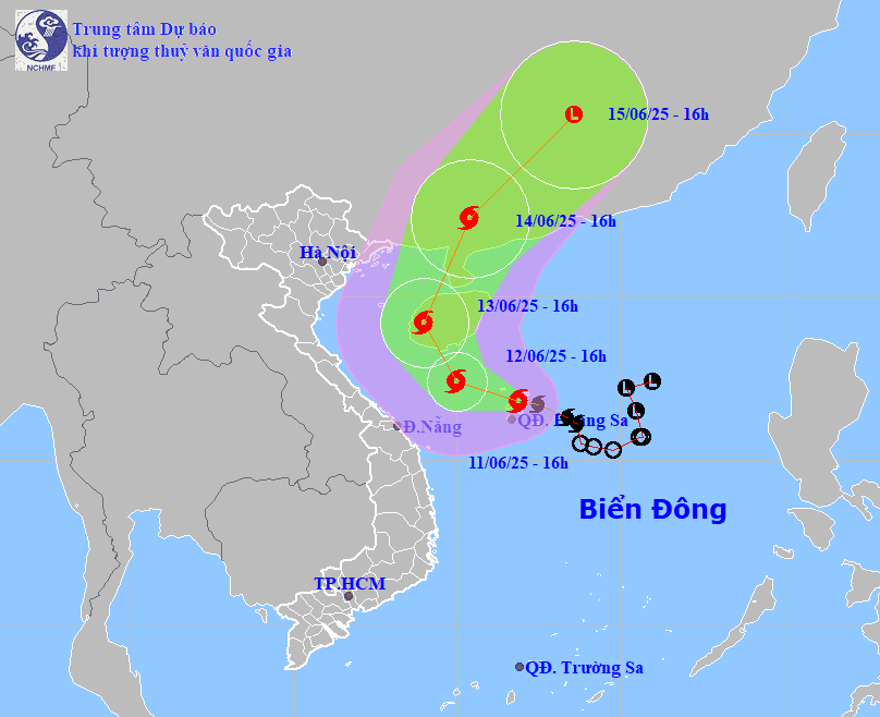
| Forecast map of storm No. 1's trajectory on June 11, 2025 (Source: National Center for Hydro-Meteorological Forecasting). |
Forecast by 4:00 p.m. on June 12, the center of storm No. 1 is at about 17.4 degrees north latitude, 110 degrees east longitude in the sea south of Hainan Island (China); with the strongest wind level 9-10, gusting to level 13; the storm is moving west-northwest at a speed of about 10km/hour and is likely to strengthen.
Due to the influence of the storm, the western area of the North East Sea (including the sea area of Hoang Sa archipelago) has strong winds of level 7-8, the area near the storm's eye has winds of level 9-10, gusts of level 13, waves 3-5m high, the area near the storm's eye has waves 4-6m high, very rough seas.
From tonight (June 11), the sea off the coast of Da Nang city will have winds gradually increasing to level 6-8, near the storm's eye level 9-10, gusting to level 13, waves 3-5m high, very rough seas.
During the night of June 11 and June 12, the sea area of Da Nang city will have winds gradually increasing to level 6-7, near the storm center level 8-9, gusting to level 11, rough seas, wave height 2-4, near the storm center 3-5m.
In addition, in the evening and night of June 11, there will be scattered showers and thunderstorms in the sea area of Da Nang; and heavy showers and thunderstorms in the sea area of Hoang Sa archipelago. During thunderstorms, be on guard against tornadoes, whirlwinds and strong gusts of wind.
During the night of June 12 and June 13, the sea area of Da Nang city will have strong southwest winds at level 6, gusting to level 7-8, rough seas, and waves 2-4m high; the sea area of Hoang Sa archipelago will have strong southwest winds at level 6-7, gusting to level 8-9, rough seas, and waves 3-5m high.
Ships operating in the above mentioned dangerous areas are likely to be affected by storms, whirlwinds, strong winds and large waves.
Due to the influence of storm No. 1, from the afternoon of June 11 to June 13, Da Nang city experienced moderate rain, heavy rain, and very heavy rain and thunderstorms. Total rainfall in Hoa Vang and Cam Le districts was generally 80-150mm, with some places receiving over 250mm; in Son Tra, Ngu Hanh Son, Lien Chieu, Thanh Khe and Hai Chau districts was generally 100-200mm, with some places receiving over 300mm; in Hoang Sa island district, it was 100-200mm, with some places receiving over 250mm.
Warning of risk of heavy localized rain (rainfall more than 100mm in 3 hours).
From the afternoon of June 13, in districts of Da Nang city, rain tends to decrease gradually, there is still scattered rain and showers, some places have moderate rain.
The city needs to guard against flash floods, landslides in mountainous areas and flooding in low-lying areas and urban areas.
HOANG HIEP
Source: https://baodanang.vn/xa-hoi/202506/da-nang-mua-lon-de-phong-ngap-ung-do-thi-gio-manh-tren-bien-4008552/


Comment (0)