
")
Measures proposed by the Ministry of Agriculture and Environment include inspecting boats, preparing plans to evacuate coastal residents, ensuring the safety of dykes, reservoirs and essential infrastructure, and promptly informing people about weather developments.
Northern and Central regions continue to have heavy rain due to tropical depression
The National Center for Hydro-Meteorological Forecasting warns that from the night of August 16 to August 18, many areas in the North and Central regions will experience moderate to heavy rain with thunderstorms, with the risk of very heavy rain in some areas. Specifically, the Northeast, Thanh Hoa and Nghe An are expected to have widespread rainfall of 50-120mm, some places over 250mm, while the northern mountainous areas will have rain of 30-80mm, some places over 150mm.

At the same time, the Central Highlands and the South will have moderate rain, heavy rain and thunderstorms with common rainfall of 20-50mm, locally over 100mm. Particularly, Ha Tinh and Quang Tri will have moderate rain, heavy rain, common rainfall of 30-70mm, locally over 120mm during the day and night of August 17. Other areas such as the Northwest, the area from Ha Tinh to Hue and the South Central Coast will also have scattered showers and thunderstorms, locally heavy rain with common rainfall of 10-30mm, locally over 80mm.
Then, from the night of August 18 to August 19, the North and Thanh Hoa continued to have moderate rain, heavy rain with thunderstorms, locally very heavy rain with common rainfall of 30-80mm, some places over 150mm.
Tropical depression is moving north
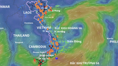
Previously, the National Center for Hydro-Meteorological Forecasting informed that on the evening of August 16, the low pressure area in the sea south of Hoang Sa special zone had strengthened into a tropical depression.
The center of the tropical depression is located at 16 degrees North latitude - 112.8 degrees East longitude, with intensity level 6, gust level 8, moving northwest at a speed of about 10km/hour.

It is forecasted that in the next 24-72 hours, the tropical depression will continue to move northwest. By the evening of August 17, the center of the tropical depression will be about 60km southeast of Hainan Island (China), with intensity at level 6-7, gusting to level 9.
On August 18, the tropical depression continued to move north of the Gulf of Tonkin, maintaining level 6 intensity, gusting to level 8.
The National Center for Hydro-Meteorological Forecasting warns that the Northwestern sea of the East Sea and Hoang Sa will have thunderstorms, strong winds of level 6-7, gusts of level 8-9, and waves of 2-3.5m high. The Northwestern sea of the Gulf of Tonkin will gradually increase to level 6, gusts of level 8, waves of 2-3m, and rough seas from the morning of August 18.
Source: https://www.sggp.org.vn/bo-nong-nghiep-va-moi-truong-de-nghi-ung-pho-ap-thap-nhiet-doi-post808766.html


Comment (0)