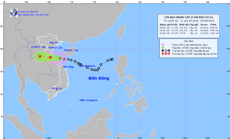
Path of storm No. 6 at noon on August 30
This morning (August 30), storm No. 6 formed in the East Sea and at 10am, the storm was in the Ha Tinh - Quang Tri sea area. With the strongest wind speed of level 8 (62-74 km/h), gusting to level 10-11, the storm is moving West Northwest at a speed of 20-25 km/h.
Due to the influence of storm No. 6, at Bach Long Vi, the wind is level 7, gusting to level 9; at Co To, the wind is level 6-7, gusting to level 8; at Con Co, the wind is level 6, gusting to level 8. The provinces from Nghe An to Da Nang have had heavy rain, some places with very heavy rain of over 170mm.
Head of the Weather Forecast Department, National Center for Hydro-Meteorological Forecasting Nguyen Van Huong said: By noon today, the storm will move into the southern part of the Gulf of Tonkin, about 200 km east of the mainland of the provinces from Ha Tinh to Quang Tri . It is forecasted that this evening, the storm's eye will make landfall in the provinces from southern Ha Tinh to northern Quang Tri, with strong winds of level 6-7, near the storm's eye level 8. Gusts may reach level 9-10. Along the coast from Thanh Hoa to Thua Thien Hue, there will be strong winds of level 6, near the storm's eye level 7-8, gusts of level 9-10.
Along with the impact of strong winds, storm No. 6 will cause rain with heavy rain concentrated from Thanh Hoa to Quang Tri. The total rainfall for the period is estimated at 200-400 mm, with some places over 600 mm. From now until the end of August 31, this area will have rain of 150-250 mm, with some places over 350 mm. The rain will also spread to the midlands and the Northern Delta from the evening and night of August 30 to the end of August 31. The common rainfall is 50-120 mm, with some places over 200 mm.
Forecast (next 12-24 hours): 10pm August 30: The storm moves west-northwest at 20 km/h, makes landfall in Ha Tinh - northern Quang Tri, weakens into a tropical depression. Location 18.1°N - 105.3°E (Vietnam - Laos border). Wind level 6, gust 8.
10:00 a.m. August 31: Continue moving West Northwest at 20 km/h, entering Central Laos, weakening into a low pressure area (< level 6).
Disaster risk level: level 3, Thanh Hoa - Hue City sea area (including Hon Ngu, Con Co).
At sea: Thanh Hoa - Hue City (Hon Ngu, Con Co) wind level 6-7, near the storm center level 8, gust 10; waves 2-4 m, near the storm center 3-5 m, rough sea. Northern Bac Bo Gulf wind level 6-7, gust 9; waves 2-4 m. Rising water: Nghe An - Hue City 0.2-0.4 m high.
Weather forecast for National Day September 2nd is quite favorable
The hydro-meteorological agency said that storm No. 6 ended quite quickly, so the heavy rain did not last long, only lasting until August 30-31. From September 1 onwards, rain across the country tends to decrease.
The weather forecast for National Day, September 2nd, is generally favorable. Specifically, Hanoi and the Northern region will have light showers in the morning, from noon and afternoon the rain will decrease, the weather will turn to light sunshine.
The weather in the Central region will remain sunny during the day. Meanwhile, the Central Highlands and the South will be sunny during the day, with scattered showers and thunderstorms in the evening and at night. In general, the weather across the country on the national holiday of September 2nd is generally favorable for outdoor activities.
Thu Cuc
Source: https://baochinhphu.vn/bao-so-6-di-vao-dat-lien-chieu-toi-30-8-gay-mua-lon-102250830122841312.htm




![[Photo] People eagerly lined up to receive special publications of Nhan Dan Newspaper](https://vphoto.vietnam.vn/thumb/1200x675/vietnam/resource/IMAGE/2025/8/30/53437c4c70834dacab351b96e943ec5c)



























Comment (0)