
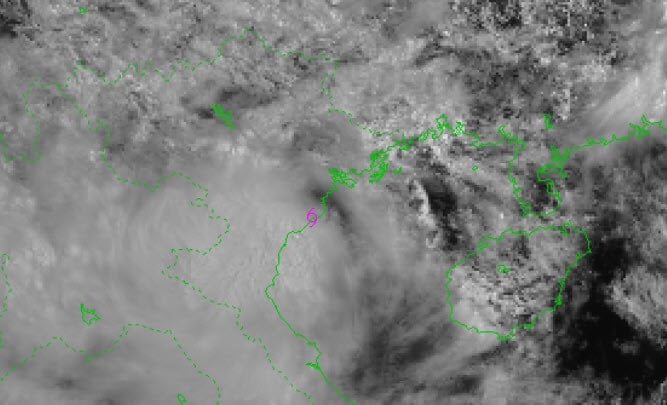
Accordingly, at 10:00 a.m. on July 22, the storm center was located at about 20.2 degrees North latitude; 106.4 degrees East longitude, located on the coastal mainland between Hung Yen and Ninh Binh , the strongest wind near the storm center was level 8 - 9 (62 - 88 km/h), gusting to level 11. It is forecasted that in the next 3 hours, the storm will move in a West Southwest direction, at a speed of about 10 - 15 km/h.
The meteorological agency assessed that, as of 7 p.m. on July 22, the center of the storm was at about 19.9 degrees North latitude; 105.5 degrees East longitude, located on the mainland from Hai Phong to Thanh Hoa; the strongest wind near the center of the storm was level 6, gusting to level 8; the storm moved in a West-Southwest direction, at a speed of about 10-15 km/hour and gradually weakened into a tropical depression.
Due to the impact of storm No. 3 and its circulation, it is forecasted that from July 22 to 23, in the Northern Delta, Thanh Hoa and Nghe An, there will be heavy to very heavy rain and thunderstorms with common rainfall of 100 - 200 mm, locally over 300 mm; other places in the Northern region and Ha Tinh will have moderate to heavy rain, locally very heavy rain and thunderstorms with common rainfall of 50 - 100 mm, locally over 150 mm. Heavy rainfall in a short period of time can cause flash floods, landslides in mountainous areas, and flooding in low-lying areas.
Source: https://hanoimoi.vn/bao-so-3-do-bo-dat-lien-hung-yen-va-ninh-binh-gio-giat-cap-11-709979.html


![[Photo] National Assembly Chairman Tran Thanh Man visits Vietnamese Heroic Mother Ta Thi Tran](https://vphoto.vietnam.vn/thumb/1200x675/vietnam/resource/IMAGE/2025/7/20/765c0bd057dd44ad83ab89fe0255b783)


Comment (0)