
 |
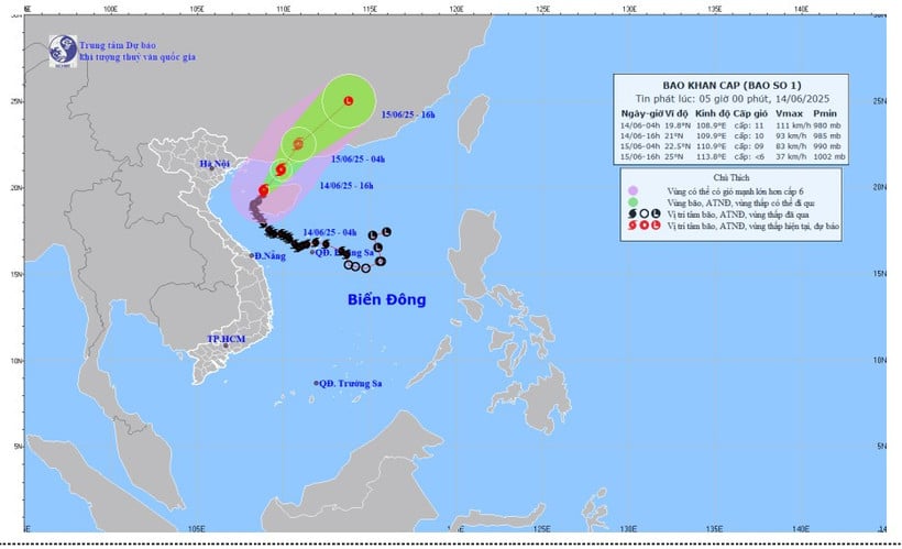
| Forecast map of storm No. 01's trajectory and intensity at 5:00 a.m. on June 14, 2025. |
Forecast in the next 3 hours, the storm moves in the North Northeast direction, speed about 10 km/hour.
Due to the influence of storm No. 1, in Bach Long Vi island district, there are strong winds of level 7, gusting to level 8-9; in Con Co island district (Quang Tri), there are strong winds of level 7, gusting to level 8; in Bai Chay and Cua Ong ( Quang Ninh ), there are strong winds of level 6.
Previously, at 4:00 a.m. on June 14, the center of the storm was located at about 19.8 degrees North latitude; 108.9 degrees East longitude, in the sea east of the Gulf of Tonkin, about 150km east of Bach Long Vi island. The strongest wind near the center of the storm was level 10-11 (89-117km/h), gusting to level 13; moving north at a speed of 5km/h.
Due to the impact of the storm, the sea area of Bac Bo Gulf (including Co To and Bach Long Vi island districts) has strong winds of level 7, the area near the storm's eye has winds of level 8-9, gusts of level 13, waves 2-4m high, especially in the East 4-6m, very rough seas.
The Northwestern part of the North East Sea has strong winds of level 6, gusting to level 8, waves 2-4m high, rough seas. Ships operating in the above-mentioned dangerous areas are likely to be affected by storms, whirlwinds, strong winds, and large waves.
The coastal area of Quang Ninh- Hai Phong has strong winds of level 6, gusting to level 8; the coastal area of Thai Binh-Nam Dinh has strong winds of level 4-5, gusting to level 6-7.
Source: https://huengaynay.vn/chinh-tri-xa-hoi/bao-so-1-giat-cap-13-cach-dao-bach-long-vi-khoang-140km-ve-phia-dong-154675.html


![[Photo] Prime Minister Pham Minh Chinh receives leaders of several Swedish corporations](https://vphoto.vietnam.vn/thumb/1200x675/vietnam/resource/IMAGE/2025/6/14/4437981cf1264434a949b4772f9432b6)


Comment (0)