The above weather pattern causes many areas in the East Sea to have thunderstorms, tornadoes, strong winds of level 6 - 7 and waves of over 2 - 4.5 m high; on land in the Central and Southern regions there is widespread rain, locally heavy rain.
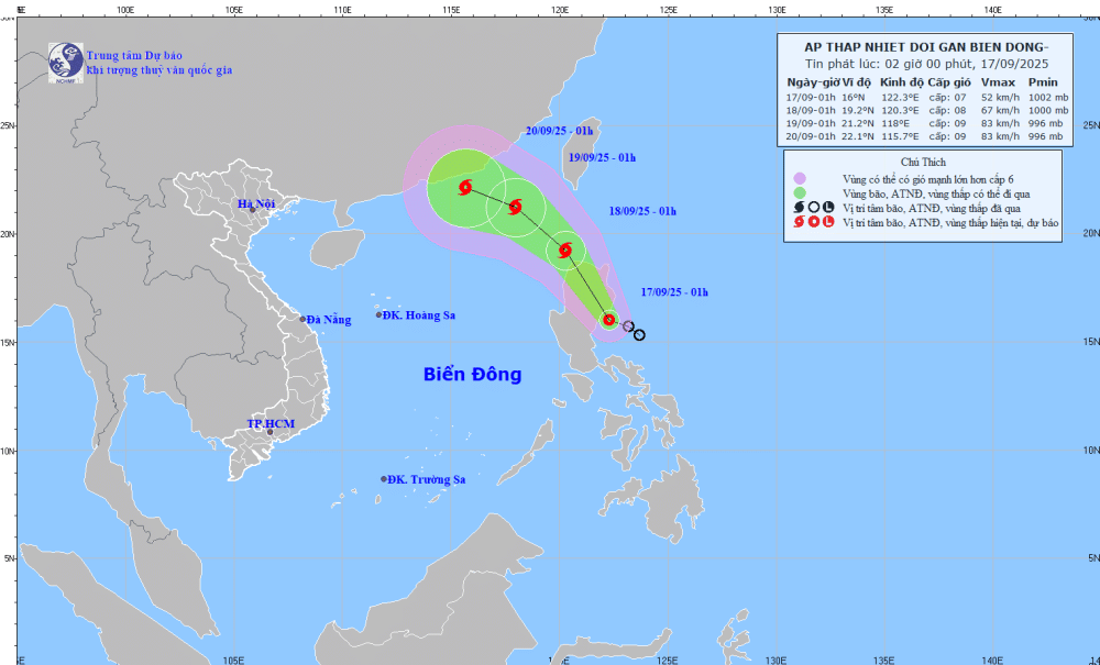
The tropical depression near the East Sea is strengthening and is likely to become a storm, connecting with the tropical convergence zone, causing bad weather for the Central and Southern regions (SOURCE: NCHMF)
According to the National Center for Hydro-Meteorological Forecasting, at 1:00 a.m. on September 17, the center of the tropical depression was in the sea east of Luzon Island (Philippines). The strongest wind near the center was level 7 (from 50 - 61 km/h), gusting to level 9. Moving west-northwest at a speed of about 15 km/h.
Forecast by 1:00 a.m. on September 18, the center of the tropical depression is over the sea north of Luzon Island (Philippines). The intensity is level 8, gusting to level 10. By 1:00 a.m. on September 19, it is likely to enter the northeastern area of the East Sea and strengthen into a storm with an intensity of level 8 - 9, gusting to level 11.
Due to the tropical convergence zone with its axis passing through the northern East Sea connecting with the tropical depression in the sea east of Luzon Island, the sea area from southern Quang Tri to Gia Lai , the northern, central and southern East Sea areas (including Hoang Sa and Truong Sa special zones) will have scattered showers and thunderstorms.
On the night of September 17, the northeastern sea area of the northern East Sea will have winds gradually increasing to level 6 - 7, gusting to level 9; near the storm center, winds will be level 8, gusting to level 10, rough seas, waves 2.5 - 4.5m high.
The central East Sea area has winds of level 5, sometimes level 6, gusting to level 7-8, rough seas, waves 2-3m high.
The Gulf of Tonkin, the sea from southern Quang Tri to Ca Mau, Ca Mau to An Giang and the Gulf of Thailand will have scattered showers and thunderstorms; especially the northeastern sea of the northern East Sea will have storms from tonight. During the thunderstorms, there is a possibility of tornadoes, strong gusts of wind of level 6-7 and waves over 2m high.
The risk level of natural disasters due to strong winds in the northeastern sea area of the North East Sea is at level 3. All vessels operating in the above areas are at high risk of being affected by tornadoes, strong winds and large waves.
On land, from last night and early this morning (September 17), the area from Hue City to Khanh Hoa had scattered showers and thunderstorms, locally heavy rain; many places over 50mm such as: Quang Dien (Hue) 68.2mm, Ia Kenh (Gia Lai) 88.4mm, Song Hinh ( Dak Lak ) 51.8mm...
This afternoon and tonight, from Hue City to Lam Dong and the South, there will be scattered showers and thunderstorms, with rainfall of 15 - 30mm, with some places having heavy rain of over 80mm./.
According to Thanh Nien Newspaper
Source: https://thanhnien.vn/ap-thap-nhiet-doi-gan-bien-dong-dang-manh-len-thanh-bao-185250917065957698.htm
Source: https://baolongan.vn/ap-thap-nhiet-doi-gan-bien-dong-dang-manh-len-thanh-bao-a202637.html





![[Photo] General Secretary To Lam chairs a working session with the Standing Committee of the Government Party Committee](https://vphoto.vietnam.vn/thumb/1200x675/vietnam/resource/IMAGE/2025/9/17/cf3d855fdc974fa9a45e80d380b0eb7c)


![[Photo] Science and Technology Trade Union honors exemplary workers and excellent union officials](https://vphoto.vietnam.vn/thumb/1200x675/vietnam/resource/IMAGE/2025/9/17/842ff35bce69449290ec23b75727934e)




















Comment (0)