

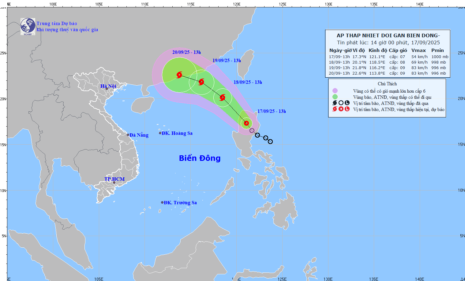
The tropical depression is moving northwest at a speed of about 15-20 km/h.
At 1 p.m. on September 18, the tropical depression in the northeastern sea of the North East Sea with strong winds of level 8, gusts of level 10; moving northwest at a speed of about 15-20 km/h, entering the East Sea and likely to strengthen into a storm. The affected area is the northeastern sea of the North East Sea. Disaster risk level 3.
At 1 p.m. on September 19, the tropical depression was in the northeastern sea of the North East Sea, about 250 km east-southeast of Hong Kong (China), with strong winds of level 8-9, gusting to level 11; moving northwest at a speed of about 15 km/h and likely to intensify. The affected area is the northeastern sea of the North East Sea. Disaster risk level 3.
From the next 48 to 72 hours, the storm will move mainly in the West Northwest direction, about 10 km per hour, with little change in intensity.
Due to the impact of the tropical depression and storm, from the evening of September 17, the northeastern sea area of the North East Sea will have winds gradually increasing to level 6-7, gusting to level 9; near the storm center, winds will be level 8, gusting to level 10, with waves 2.5-4.5m high. The sea will be rough.
Vessels operating in the above mentioned dangerous areas are susceptible to the impact of storms, whirlwinds, strong winds and large waves.
Beware of flash floods and landslides in Phu Tho and Gia Lai
According to the National Center for Hydro-Meteorological Forecasting, from 3:30 p.m. to 8:30 p.m. on September 17, the areas of Phu Tho and Gia Lai provinces will continue to have rain with common accumulated rainfall such as Phu Tho from 20-50 mm, some places over 80 mm; Gia Lai from 20-40 mm, some places over 70 mm.
Risk warning: flash floods on small rivers and streams, landslides on steep slopes in the above provinces, especially in the following communes/wards: An Binh, Cao Phong, Dung Tien, Hop Kim, Lac Luong, Lac Thuy, Lien Son, Luong Son, Muong Dong, Nat Son, Nhan Nghia, Hoa Binh , Ky Son, Tan Hoa, Thong Nhat, Thinh Minh, Thung Nai (Phu Tho province); Chu A Thai, Cuu An, Dak Po, An Khe; An Nhon Tay, Ayun, Bau Can, Binh Khe, Binh Phu, Canh Lien, Canh Vinh, Chu Krey, Dak Somei, Dak Song, Hoi Son, Ia Dom, Ia Ko, Ia Krel, Ia Nan, KBang, Lo Pang, Mang Yang, An Nhon Nam, Phu Thien, Son Lang, Sro, To Tung, Ya Hoi, Ya Ma (Gia Lai province):
Warning level of natural disaster risk due to flash floods, landslides, land subsidence due to heavy rain or level 1 flow.
Flash floods and landslides can have very negative impacts on the environment, threaten people's lives; cause local traffic congestion, affect the movement of vehicles; destroy civil and economic works, causing damage to production and socio-economic activities.
The hydrometeorological agency recommends that local authorities pay attention to reviewing bottlenecks and vulnerable locations in the area to take preventive and response measures.
From 1:00 p.m. to 2:00 p.m. on September 17, the provinces of Phu Tho and Gia Lai experienced moderate and heavy rain as follows: Dan Hoa 3 (Phu Tho) 40.8 mm, Dong Tam (Phu Tho) 39.8 mm; Thuan Phong (Gia Lai) 59.2 mm;...
Soil moisture models show that some areas in the above provinces are close to saturation (over 85%) or have reached saturation.
Flood warning in Hanoi area
According to the Northern Hydrometeorological Station, the Hanoi area is currently experiencing moderate to heavy rain. From about 3:25 p.m. to 5:25 p.m. on September 17, Hanoi and surrounding areas will continue to experience moderate to heavy rain with total accumulated rainfall ranging from about 20-30 mm, and higher in some places.
Warning: This rain will cause localized flooding for many streets with the greatest flooding depth commonly from 10 - 30 cm, some places will be deeper; flooding time is about 20-30 minutes, some places will be flooded longer. Beware of flooding in some low-lying areas in the suburbs.
Specifically, the areas that are likely to be flooded include: Tran Vu, Cao Ba Quat... (Ba Dinh ward); Lieu Giai, Doi Can street... (Ngoc Ha ward); Ngoc Khanh, Dao Tan... (Giang Vo ward); Phung Hung, Bat Dan, Duong Thanh, Trang Tien - Hang Bai intersection, Nguyen Huu Huan, Tong Dan, Dinh Liet, Ta Hien - Luong Ngoc Quyen, Nguyen Sieu - Gach alley... (Hoan Kiem ward); Phan Boi Chau - Ly Thuong Kiet, Quang Trung, Tho Nhuom intersection... (Cua Nam ward); Van Ho, Nguyen Cong Tru, Ba Trieu, Lo Duc, Lien Tri - Nguyen Gia Thieu intersection (Hai Ba Trung ward); Minh Khai, Mac Thi Buoi... (Vinh Tuy ward);
Thanh Dam...(Vinh Hung ward); Thai Ha, Lang Ha, Huynh Thuc Khang...(Dong Da ward); Nguyen Khuyen, Le Duan...(Van Mieu - Quoc Tu Giam ward); Truong Chinh, Ton That Tung, Chua Boc...(Kim Lien ward); Hoa Bang, Cau Giay, Xuan Thuy, Phan Van Truong, Pham Hung, Pham Van Bach, Ton That Thuyet, Duy Tan, Tran Quoc Hoan...(Cau Giay ward); Yen Hoa, Nguyen Khang, Duong Dinh Nghe, Le Van Luong, Nam Trung Yen...(Yen Hoa ward); To Hieu, Nguyen Phong Sac, To Hieu, Nguyen Khanh Toan...(Nghia Do ward); Trich Sai, Au Co, Thuy Khue...(Tay Ho ward);
Phu Xa...(Phu Thuong ward); Xuan Dinh...(Xuan Dinh ward); Pham Van Dong and Tan Xuan streets...(Dong Ngac ward); Doan Ke Thien and Mai Dich...(Phu Dien ward); Nhon station...(Tay Tuu ward); Tran Binh, underpass for people through Thang Long avenue...(Tu Liem ward)...
Level 1 flood disaster risk.
Heavy rain is likely to cause flooding on some streets, affecting traffic. Drivers should drive slowly, follow traffic signs and instructions from authorities to ensure safety.
Source: https://baotintuc.vn/xa-hoi/ap-thap-nhiet-doi-huong-vao-bien-dong-va-kha-nang-manh-len-thanh-bao-20250917160113001.htm
![[Photo] Inside the Imperial Academy relic of Hue Citadel before the hundred billion dollar restoration](https://vphoto.vietnam.vn/thumb/1200x675/vietnam/resource/IMAGE/2025/9/18/77fd186af68341b1a8bffd072fa896a6)

![[Photo] National Assembly Chairman Tran Thanh Man begins attending AIPA-46 activities](https://vphoto.vietnam.vn/thumb/1200x675/vietnam/resource/IMAGE/2025/9/18/73487ff8ed57412eab9211273946c14d)


Comment (0)