

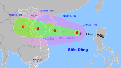
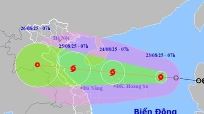
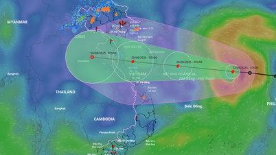
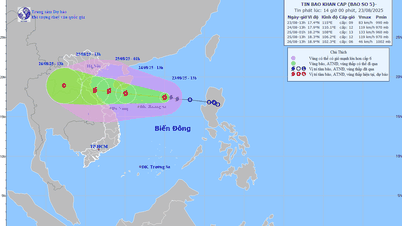
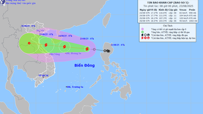
The tropical depression entered the eastern sea of the North East Sea last night, August 22, and at 1:00 a.m. on August 23, the center of the tropical depression was at about 17.1 degrees North latitude; 118.2 degrees East longitude, about 730 km east of Hoang Sa archipelago. The strongest wind near the center of the tropical depression was level 7 (50 - 61 km/h), gusting to level 9; moving in the West Northwest direction at a speed of about 25 km/h.
In the next 24 hours, the North East Sea area, including the Hoang Sa sea area, will have strong winds of level 6 - 7, then increasing to level 8; the area near the storm's center will have strong winds of level 9 - 10, gusting to level 12. The sea will be very rough, with waves 3 - 5m high, and 4 - 6m near the center. The Central East Sea area, the sea area from Khanh Hoa to Lam Dong, will have strong southwest winds of level 5 during the day, sometimes level 6; at night, it will increase to level 6, gusting to level 7 - 8; the waves will be 2 - 3m high, rough sea.
In addition, the North East Sea area (including Hoang Sa sea area) has storms; the Central and South East Sea area (including Truong Sa), the sea area from Gia Lai to Ca Mau, from Ca Mau to An Giang and the Gulf of Thailand have scattered showers and thunderstorms, with the possibility of tornadoes, strong gusts of wind level 6 - 7 and waves over 2m high during thunderstorms.

It is forecasted that today, the tropical depression will strengthen into storm number 5, move quickly towards our mainland and continue to increase in intensity.
Forecast models in Vietnam and the world show that the storm could strengthen to level 9, gusting to level 11 on the morning of August 24, and when approaching the sea area from Nghe An to Hue, it could reach level 11-12, gusting to level 15.

Many meteorological experts believe that due to its fast moving speed, the storm is forecast to make landfall in less than 48 hours, most likely in the North Central region. From tomorrow night, August 24, the Thanh Hoa to Hue area will have heavy to very heavy rain, accompanied by the risk of flooding, flash floods, and landslides.
* According to the National Center for Hydro-Meteorological Forecasting, on August 23, the mountainous areas of the North will continue to have scattered showers and thunderstorms, with heavy rain in some places.
Rainfall recorded from 7pm on August 22 to 0am on August 23 was over 50mm in some places, typically at Cao Bo 2 station (Tuyen Quang) 84.4mm; Pha Khinh station (Son La) 84.4mm; Pu Nhung station (Dien Bien) 59.0mm.
In the next 24 hours, the mountainous areas of the North are forecast to have scattered showers and thunderstorms, with rainfall ranging from 10 to 30 mm, with some places experiencing heavy rain of over 80 mm, concentrated in the early morning, late afternoon and night. The Central Highlands and the South are also forecast to have scattered showers and thunderstorms, with rainfall ranging from 10 to 30 mm, with some places experiencing heavy rain of over 60 mm. During thunderstorms, there is a possibility of tornadoes, lightning, hail, and strong gusts of wind; there is a risk of flash floods on small rivers and streams and landslides in mountainous areas.
On August 23 and 24, the North continued to have scattered showers and thunderstorms, concentrated in the late afternoon and at night. Some places in mountainous areas such as Tuyen Quang, Son La, Dien Bien had localized heavy rains of over 80mm. Floods on the Trung River through Lang Son and the Thuong River through Bac Ninh are gradually decreasing but remain at high levels, above alert level 3.

The Central region will have sunny weather in the next two days, with showers and thunderstorms in the afternoon and evening. From the night of August 24 to the end of August 27, when storm No. 5 directly affects the area from Thanh Hoa to Hue, there will be heavy rain ranging from 150-300mm, with some places experiencing over 600mm.
The Central Highlands and the South will also have scattered showers and thunderstorms in the afternoon and evening in the coming days, with heavy rain over 60mm in some places, accompanied by whirlwinds, lightning, and strong gusts of wind. During the day, many places will still be sunny.
Meteorological experts have recommended that localities in the affected areas proactively prepare for response plans, especially the Central region, to prepare for prolonged heavy rain, flash floods and landslides.
Source: https://www.sggp.org.vn/ap-thap-nhiet-doi-da-vao-bien-dong-hom-nay-thanh-bao-so-5-post809732.html


![[Photo] General Secretary To Lam attends the 80th Anniversary of the Cultural Sector's Traditional Day](https://vphoto.vietnam.vn/thumb/1200x675/vietnam/resource/IMAGE/2025/8/23/7a88e6b58502490aa153adf8f0eec2b2)


Comment (0)