
 |
| Forecast map. |
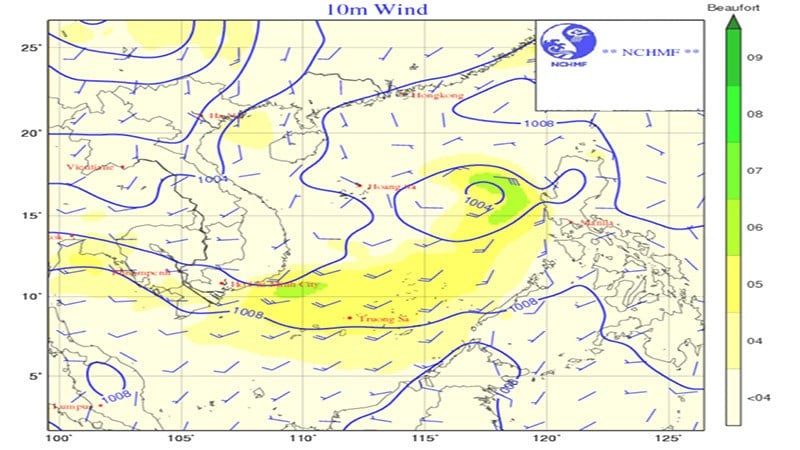
At 7:00 a.m. on June 24, the low pressure area was located at 14.5-15.5 degrees North latitude, 117.5-118.5 degrees East longitude. It is forecasted that in the next 24 hours, the low pressure area will move slowly northwestward and is likely to strengthen into a tropical depression.
Thunderstorm warning in the eastern sea area of the northern East Sea, the middle and southern East Sea (including the waters of Truong Sa archipelago), the sea area from Binh Thuan to Ca Mau, Ca Mau to Kien Giang, and the Gulf of Thailand.
The sea area from Binh Thuan to Ca Mau has strong southwest winds of level 5, sometimes level 6, gusting to level 7, waves from 1.5-2.5m high, rough sea.
During thunderstorms, there is a possibility of tornadoes, strong winds of level 6-7, and waves over 2m high.
Due to tornadoes, strong gusts of wind pose a danger to ships.
Ocean wave forecast for the period 24/06 - 26/06
Northern Gulf of Tonkin: Waves 1 - 2m high, then gradually decreasing, from southeast to south. Southern Gulf of Tonkin: Waves 0.5 - 1.5m high, from southeast. Quang Tri - Quang Ngai: Waves 0.5 - 1.5m high, from southeast. Binh Dinh - Ninh Thuan: Waves 1.5 - 2.5m high, from south to southwest. Binh Thuan - Ca Mau: Waves 2 - 3m high, from southwest. Ca Mau - Kien Giang & Gulf of Thailand: Stable wave height 0.5 - 1.5m, from southwest to west. Northern East Sea (including Hoang Sa archipelago): Waves 2 - 3m high, from many directions, then decreasing to 1 - 2m, from southwest to south. Middle East Sea: Waves 1.5 - 2.5m high, from southwest. South China Sea (including Truong Sa archipelago): Waves 1.5 - 3m high, then decreasing to 1-2m, southwest direction.
According to nhandan.vn
Source: https://baoapbac.vn/xa-hoi/202506/vung-ap-thap-tren-khu-vuc-bien-dong-co-kha-nang-manh-len-thanh-ap-thap-nhiet-doi-1046038/


![[Photo] General Secretary To Lam meets with the Group of Young National Assembly Deputies](https://vphoto.vietnam.vn/thumb/1200x675/vietnam/resource/IMAGE/2025/6/24/618b5c3b8c92431686f2217f61dbf4f6)


![[Infographic] Regulations on decentralization and delegation in the fields of culture, sports and tourism](https://vphoto.vietnam.vn/thumb/402x226/vietnam/resource/IMAGE/2025/6/25/880a409a8682407a8e784cbc77960ac9)


Comment (0)