
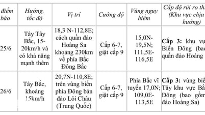
On the morning of June 24, the National Center for Hydro-Meteorological Forecasting informed about the low pressure area in the East Sea, at a position of about 14 degrees north latitude - 119 degrees east longitude.

Low pressure area formed in the East Sea on the morning of June 24.
PHOTO: NATIONAL CENTER FOR HYDRO-METEORO-METEORO-GEOLOGICAL FORECASTING
At 7:00 a.m. on June 24, the low pressure area was located at 14.5 - 15.5 degrees north latitude; 117.5 - 118.5 degrees east longitude. Currently, this low pressure area has connected with the low pressure trough with an axis of 14 - 17 degrees north latitude, which will cause dangerous weather in many coastal areas.
Thunderstorms are forecast to occur throughout the eastern seas of the northern East Sea, the middle and southern East Sea (including the waters of the Truong Sa archipelago); the seas from Binh Thuan to Ca Mau, Ca Mau to Kien Giang, and the Gulf of Thailand.
In addition, the sea area from Binh Thuan to Ca Mau has strong southwest winds of level 5 - 6, gusting to level 7. Waves are 1.5 - 2.5 m high, rough seas. During thunderstorms, there is a possibility of tornadoes, strong gusts of level 6 - 7, waves over 2 m high.
Accordingly, all vessels operating in the above sea areas are at high risk of being affected by tornadoes, strong gusts of wind and large waves.
According to the National Center for Hydro-Meteorological Forecasting, in the next 24 hours, the low pressure area will move slowly northwestward and is likely to strengthen into a tropical depression. Fishermen and vessels operating in the above sea areas should closely monitor forecast information, avoid entering dangerous areas; proactively take precautions to ensure safety for people and vehicles at sea.
Source: https://thanhnien.vn/vung-ap-thap-tren-bien-dong-se-manh-len-thanh-ap-thap-nhiet-doi-185250624093219113.htm
![[Photo] General Secretary To Lam works with the Standing Committee of Quang Binh and Quang Tri Provincial Party Committees](https://vphoto.vietnam.vn/thumb/1200x675/vietnam/resource/IMAGE/2025/6/25/6acdc70e139d44beaef4133fefbe2c7f)
![[Photo] More than 124,000 candidates in Hanoi complete procedures for the 2025 High School Graduation Exam](https://vphoto.vietnam.vn/thumb/1200x675/vietnam/resource/IMAGE/2025/6/25/fa62985b10464d6a943b58699098ae3f)
![[Photo] First training session in preparation for the parade to celebrate the 80th anniversary of National Day, September 2nd](https://vphoto.vietnam.vn/thumb/1200x675/vietnam/resource/IMAGE/2025/6/25/ebf0364280904c019e24ade59fb08b18)


Comment (0)