

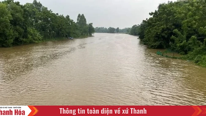
Accordingly, the water level in the Mekong Delta last week tended to increase quite strongly with an average intensity of 7.5 cm/day due to upstream floods and rising tides. The current water level at the main riverside stations is generally above alert level 3. Particularly at Ca Mau station (Ca Mau province), the water level last week remained above alert level 3.
In recent days, due to the strong increase in upstream floods combined with high tides, many low-lying areas in the middle of the Mekong Delta have been inundated. Typically, the central urban areas of Can Tho City and Vinh Long Province have been heavily flooded.

The Southern Institute of Water Resources Planning said that in September 2025, there will be two high tides. The first will be on September 14 and 15 in the West Coast; the second will be in the last week of September, with the peak tide falling from September 21 to 23 in the East Sea coastal area, and on September 30 in the West Coast. At Long Xuyen Station, An Giang Province, the water level will remain high above BĐ3 for the next 3-4 days.
The rising floodwaters from upstream have created favorable conditions for people in An Giang and Dong Thap to make a living by fishing. Among them, catching linh fish is the most exciting.


Meanwhile, in Can Tho City, Vinh Long Province, in the past 2 days (September 11 and 12), the water level exceeded BĐ3, flooding many roads and some local markets along the Hau River. Therefore, thousands of people have encountered many difficulties in traveling and doing business in the markets.

It is forecasted that the flood in the upper reaches of the Mekong River will reach its highest level of 3.3m at Tan Chau at the end of September 2025. With this flood level, the infrastructure of the protective cell for production in the flooded areas of the Mekong Delta will not be affected. However, because the high tide is at its peak and is forecast to remain high in the coming days, the flood combined with high tide will cause the water level in the middle and some coastal areas of the Mekong Delta to remain high. The risk of flooding/tidal flooding continues to occur in low-lying areas and main riverside areas.
Localities in the central and coastal areas of the Mekong Delta need to be on guard against flooding due to rain, floods combined with high tides in the coming days, especially from now until September 15, 2025. Localities at high risk of flooding include central urban areas in Can Tho City and Vinh Long Province, the area between the two rivers in Dong Thap Province, the central area of Ca Mau Peninsula in the Quan Lo - Phung Hiep, Cai Lon - Cai Be irrigation systems, and the Northern Ca Mau irrigation sub-region.
Source: https://www.sggp.org.vn/dbscl-lu-vuot-bao-dong-3-dau-nguon-soi-dong-muu-sinh-cuoi-nguon-chat-vat-ung-pho-ngap-post812815.html
![[Photo] Science and Technology Trade Union honors exemplary workers and excellent union officials](https://vphoto.vietnam.vn/thumb/1200x675/vietnam/resource/IMAGE/2025/9/17/842ff35bce69449290ec23b75727934e)


![[Photo] General Secretary To Lam chairs a working session with the Standing Committee of the Government Party Committee](https://vphoto.vietnam.vn/thumb/1200x675/vietnam/resource/IMAGE/2025/9/17/cf3d855fdc974fa9a45e80d380b0eb7c)


Comment (0)